DJI Mavic, Air and Mini Drones
Friendly, Helpful & Knowledgeable Community
Join Us Now

The BIG GNSS (GPS) Issue -- The Constructive Thread

It's an interesting capability and one with obvious security concerns but as I understand it, the vast majority of Beidou receivers are receive-only and cannot transmit. I am first to admit my limited understanding here, but I would have thought TX ability would require amplification circuits and a high gain antenna to get the signal all the way back into space.
My understanding is that it is intended for SAR type functionality and that the EU Galileo system is developing the same SAR capability.

As you said, it will require specific hardware, so todays receive-only chips are not affected.
 
Some observations, FWIW:

In consideration of rumored AGPS capability via the RC Pro, I flew the last several flights making sure to power up the RC Pro, confirm solid internet with Fly app open before turning on the Mavic 3.

This made no discernible difference in the time to first home point. Around 3 to 5 minutes for each cold boot. I compared this to my phone (Iphone 13) and the Mavic 3 took considerably longer each time, about 5 to 10 times longer. If there is AGPS capability there, it is not working or is not implemented in a way to provide much benefit.

I also noticed that the interval for a warm boot is pretty short. Despite several flights throughout the day within a five mile radius, only once did I get an obvious warm boot in which the satellite count jumped from 0 to 18 within 30 seconds of boot. Other times, maybe one hour apart, it performed more like a cold boot taking minutes instead of seconds.
 
Out of the blue here but do a cold imu like from the refrigerator.
maybe that might change your issues. Most likely not but try anything different. I know don’t flame me but after 63 post you
guys are just going round and round. I’ve seen off the wall test
do weird things 🤷‍♂️
 
  • Like
Reactions: GadgetGuy
@dirkclod, weirder things have happened! 😀

And while we try these off the wall (in the fridge) solutions, I'll pepper in more anecdotal data. Two flights yesterday. Typical LA weather, 72 and sunny. Unobstructed sky. The majority of the first flight was limited to 14 satellites and then finally, towards the end, jumped up to 22. Second flight was 23 almost the whole time.

Those numbers are interesting. Almost exactly 2/3 and 1/3. 14 was not uncommon on drones working with two constellations. Which brings up some questions:

1. Are solutions computed for each constellation and then merged or are signals from a Beidou satellite used with Galileo and GPS satellites to compute the overall solution without regard for constellation at all?

2. If there are different solutions for each constellation, how are they merged?

3. Are there scenarios in which signals from one constellation do not combine nicely or precisely with others? There was already mention of RF overlap but what about issues/differences in the implementation of the carrier signal, timing, etc.?

P.S. RC Pro does use A-GPS. For itself. As a test, I used GPS Test on the RC Pro when I powered up the Mavic 3. The RC Pro had 23 satellites in under 20 seconds. In the same time, the Mavic had 4 and took another 3 minutes to have 9 before I gave up and took off.
 
  • Like
Reactions: dirkclod
Which brings up some questions:

1. Are solutions computed for each constellation and then merged or are signals from a Beidou satellite used with Galileo and GPS satellites to compute the overall solution without regard for constellation at all?

2. If there are different solutions for each constellation, how are they merged?

3. Are there scenarios in which signals from one constellation do not combine nicely or precisely with others? There was already mention of RF overlap but what about issues/differences in the implementation of the carrier signal, timing, etc.?
There have been fusion solutions for GPS + GLONASS for many years now - in other words the GNSS chips don't solve each constellation separately and then combine - they combine the signals and then solve. It's not totally trivial since there are some subtleties such as different time offsets between systems.

There are also multi-system solutions for GPS + GLONAS + Galileo + BeiDou, and so I would expect that any given GNSS chip would incorporate a multi-system algorithm for the constellations that it receives.

No question on the multi-constellation capability. That has been around for some time. I think there are now common chips that can use 4 constellations at once though I think we are using one that is limited to 3.

However, I am curious to learn more about how they are merged and those subtleties. My understanding is that different combinations can produce different results. Standalone, they have different capabilities. GPS and Galileo are more accurate than Beidou and GLONASS.

I've also read that triple frequency solutions like GPS + Galileo + Beidou can actually be very precise using capabilities like carrier phase detection and differential delay.

Side question: Is there no way to get an NMEA log from the drone for a flight? That would tell us a lot (or not).
 
Just a little info from the GPS Test app. I am near Nashville, TN. ZERO Beidou satellites show up. 17 - GPS, 8 - GLONASS, 12 - GALILEO, 0 - BEIDOU. Satellite Check app shows the same. This on a Samsung S21 Ultra.
 
We have a lot of complaining in other threads about how slow the Mavic 3 is to record a home point when starting up. We have plenty of evidence that it takes longer. But we do not have enough constructive discussion. I would like to try a different approach in this thread. There clearly is something different in how the Mavic 3 acquires satellites and records the home point. If DJI isn't going to be forthright about it (not holding my breath), there are still things we can do to move the discussion forward and maybe help ourselves.

For this thread, I'd like to offer up some areas in which we can actually start to figure some things out:

1. We know one material difference between the Mavic 3 vs. prior DJI drones is the swap of GLONASS to Beidou. We do NOT know if this change impacts how long it takes to record a home point. If there are known differences in the user experience between Beidou and GLONASS, Galileo, and GPS, it would be worth knowing. Could swapping them back make a difference? It is a mere configuration change to make it happen.

2. It appears, but I cannot say for sure, that DJI has changed their "GPS Health" criteria for recording a home point. My only evidence of this is the apparent need for 12 or more sats vs. 9 or so on older DJI drones. Not only does it take longer to get SVs but it also wants more of them to get going. Can someone reference and/or document the technical details that define the relationship between SV count, HDOP, GPS Health and the time to first home point.

3. We do NOT know if DJI is using different hardware or antennas for GNSS in the Mavic 3. A tear down would tell us if there is another newer uBlox chip in there with a Taoglass antenna or if DJI is using different parts this time which may explain some of the differences in what we're seeing. I have not seen any identification of chips, antennas in tear downs so far. If you come across them, post them here. If you have a busted Mavic 3 you want to offer up for autopsy, please let me know.

4. We need to push DJI to use A-GPS. We have expensive tablets, phones and RC Pros wired up to these things. It would not be hard to download current ephemeris and almanac data via these devices. For those not familiar, A-GPS is how the GNSS is so fast on your phone. It downloads all the SV geometry, etc. from the internet instead of trying to pull it off the GNSS signal itself. This would fundamentally change the experience. The time to first home point would be under 30 seconds every time.

5. Other topics I cannot think of?
Hin guys,
Werner from Santiago - Chile
I just sent my New Mavic 3 for Warranty, the timing for homepoint has been to long compare to Mavic II Pro.
I ask myself, why DJI extend the battery Live, if you lose it by connecting the GPS with delay over 5 minutes, this is Nonsense .
Thanks
 
  • Like
Reactions: bkushner
Be sure and let us know what they do. I’ve only had to send 2
DJI drones back over the years. And I always made some small
marks on them to see if I got back what I sent.
 
Just a little info from the GPS Test app. I am near Nashville, TN. ZERO Beidou satellites show up. 17 - GPS, 8 - GLONASS, 12 - GALILEO, 0 - BEIDOU. Satellite Check app shows the same. This on a Samsung S21 Ultra.
I see zero on my Samsung S21 here in Chicago, IL, too, via GPS Test. UAV Forecast estimates what you can see based on your location; it at least calculates I should see 7-10.

I researched it a little; Samsung specs page states the S21 supports the 4 major GNSS constellations, but also that "Galileo and BeiDou coverage may be limited. BeiDou may not be available for certain countries."

Further digging reveals that Samsung uses different chipsets for different regions that may support BeiDou or not. In GPSTest, you can actually submit your device capabilities to GPSTest and view them. I did, and it doesn't list BeiDou as supported by my chipset.

Another wrinkle I can't figure out is that the FCC have a licensing requirement for receive-only devices in the US to receive foreign RNSS signals, unless the owner of the RNSS applies for a waiver for that. Galileo got one in 2018. It's the only waiver I can see on the FCC site.
 
UAV Forecast estimates what you can see based on your location; it at least calculates I should see 7-10.
The default settings for UAV Forecast will only show a fraction of the total sats that are in your sky.
You need to configure it to see the true number.
There will always be lots of sats visible.
Another wrinkle I can't figure out is that the FCC have a licensing requirement for receive-only devices in the US to receive foreign RNSS signals, unless the owner of the RNSS applies for a waiver for that. Galileo got one in 2018. It's the only waiver I can see on the FCC site.
This has no relevance for drone users.
 
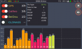
1. Are solutions computed for each constellation and then merged or are signals from a Beidou satellite used with Galileo and GPS satellites to compute the overall solution without regard for constellation at all?
I dusted off a uBlox M8U and started coding against it to see how it is operating, for fun. The paint is still very wet but for this scenario you suggested, it appears this chipset does just that:

20220211_144535.png

The "Fix Type" and "Sats In Use" data in the screenshot come from the UBX-NAV-PVT message fields fixType and numSV (number of satellites used in Nav Solution). The GNSS specific counts (eg, GPS 3/9) comes from UBX-NAV-SAT and is basically sum(svUsed)/sum(qualityInd > 3). In this scenario is it using 3 GPS, 3 Galileo and 2 BeiDou combined to produce a 3D fix overall, when that isn't possible from just one of them, with a max of 3 sats code locked/time sync'd.
 
  • Like
Reactions: sar104
So, if anyone wants to know. I downgraded the RC and drone to the previous firmware .400 and ran a test. Drone took 2 minutes to get a full home point lock with 12 sats. When I flew I turned off wifi and only had mobile data on because Dji suggests that this will speed up the sat lock( A load of hogwash I believe) , Put drone down and removed battery and left for 2 hours to get a cold start again, turned phone to airplane mode so no internet at all on cellphone and drone locked full sats(12) and home point in under 2 minutes. Today is raining with no clear skies at all. So we can confirm and already know that Dji messed this up with the latest firmware.
 
I dusted off a uBlox M8U and started coding against it to see how it is operating, for fun. The paint is still very wet but for this scenario you suggested, it appears this chipset does just that:

View attachment 143791

The "Fix Type" and "Sats In Use" data in the screenshot come from the UBX-NAV-PVT message fields fixType and numSV (number of satellites used in Nav Solution). The GNSS specific counts (eg, GPS 3/9) comes from UBX-NAV-SAT and is basically sum(svUsed)/sum(qualityInd > 3). In this scenario is it using 3 GPS, 3 Galileo and 2 BeiDou combined to produce a 3D fix overall, when that isn't possible from just one of them, with a max of 3 sats code locked/time sync'd.

Curious as to why only 2 Beidou sats. We need to figure out how to decrypt the DAT files!
 
Curious as to why only 2 Beidou sats. We need to figure out how to decrypt the DAT files!
Because I'm testing as I'm writing code, so the antenna is smushed to my window with only a partial view of the sky :) In this case though, the less the better to see that scenario.
 
Be sure and let us know what they do. I’ve only had to send 2
DJI drones back over the years. And I always made some small
marks on them to see if I got back what I sent.
In recent years, they never send back what is sent. They create a repair invoice, "pay" it via warranty or Refresh coverage or owner payment, and then send out a Refurb replacement. Serial numbers will be completely different. Did you ever receive any of your original aircraft back?
 
  • Like
Reactions: dirkclod
In recent years, they never send back what is sent. They create a repair invoice, "pay" it via warranty or Refresh coverage or owner payment, and then send out a Refurb replacement. Serial numbers will be completely different. Did you ever receive any of your original aircraft back?
Did 1 but the other no. They were both phantoms.
Sorry guys I scan so fast reading in most of our forums I forget
which one I’m in 🙄
 
  • Like
Reactions: GadgetGuy

DJI Drone Deals

New Threads

Members online

Forum statistics

Threads
135,312
Messages
1,604,809
Members
163,772
Latest member
UAS0311
Want to Remove this Ad? Simply login or create a free account