


Greetings all.
I wanted to place a few images of the first scans using the Mavic in 3D mapping. I did a mapping of a mates new home over the weekend, and collected the following data;
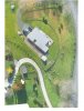
**Just adding an edit to the post with the 3D scan ** Please note this was done with only 36 images and manually flown.
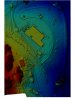
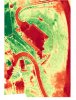
I wanted to place a few images of the first scans using the Mavic in 3D mapping. I did a mapping of a mates new home over the weekend, and collected the following data;
- Plant health
- Land elevation
- And 3D modeling
**Just adding an edit to the post with the 3D scan ** Please note this was done with only 36 images and manually flown.
Attachments
Last edited:


