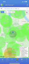
Try B4Ufly instead, much easier to understand if it is okay to fly. Looks green to me, with the caveat you have what looks to be an uncontrolled airport near by, so keep a sharp eye out for GA traffic (don't launch in the flight path of private planes).
Here's a link near your location:
https: // b4ufly.aloft.ai / ?lat=42.3987141930281&long=-76.85876909723723
Can I fly my drone here? Use Air Aware on the web or mobile devices to check the airspace for federal & local UAS rules & regulations before taking flight.

b4ufly.aloft.ai


 3 Just testing new throttle expo - works great
