I have been using my IR-modified Mavic 2 Pro to do vegetation monitoring on a local National Forest (US). I did the IR conversion myself using Kolarivision directions, which was very easy! I used their IR Chrome filter to produce false color infrared images of the riparian vegetation growing along a creek. The purpose of the study was to determine the amount of recovery after a wildfire swept through the area back in 2022. Note: The Kolari IR Chrome filter is not calibrated to do NDVI vegetation index work, so I used the red (IR) band to only detect coverage in the images. Kolari's Blur IR filter is appropriate for doing NDVI crop health surveys.
Here is a description of the workflow, and some results for the process (It is OK to share these files):
A DJI Mavic 2 Pro drone, equipped with an infrared-modified camera and KolariVision IR Chrome filter, was manually flown at 120 meters AGL (the maximum legal altitude). Approximately 240 overlapping images (25% overlap) were captured along the riparian corridor. The IR Chrome filter passes blue and green wavelengths (around 470-550nm) and longer infrared wavelengths (720nm and up), which combine to produce a false color infrared image that highlights vegetated areas.
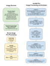
Post-processing involved generating a false color infrared orthomosaic (GeoTIFF) using Adobe Bridge, WebODM, and QGIS. Pre-fire NAIP imagery and the processed post-fire orthophoto were imported into ArcGIS Pro for georeferencing, image classification, and area calculations. Figure 2 outlines the workflow used for image processing and analysis.

Results
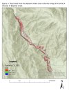
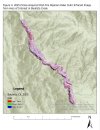
Using ArcGIS Pro’s geometry attributes tool, the total Area of Interest (AOI) was measured at 680,191.4 m² (68 ha). Riparian vegetation coverage was then calculated for pre-fire and post-fire datasets:- Pre-fire (May 5, 2022): 167,520.2 m² (16.8 ha), representing 24.6% of the AOI
- Post-fire (October 6, 2025): 122,606.6 m² (12.3 ha), representing 18.0% of the AOI


Last edited:


