DJI Mavic, Air and Mini Drones
Friendly, Helpful & Knowledgeable Community
Join Us Now

Using a Mavic 2 Pro for habitat analysis - it's still a workhorse!

AMann

Well-Known Member
Joined
Sep 30, 2018
Messages
3,481
Reactions
3,376
Location
California
I have been using my IR-modified Mavic 2 Pro to do vegetation monitoring on a local National Forest (US). I did the IR conversion myself using Kolarivision directions, which was very easy! I used their IR Chrome filter to produce false color infrared images of the riparian vegetation growing along a creek. The purpose of the study was to determine the amount of recovery after a wildfire swept through the area back in 2022. Note: The Kolari IR Chrome filter is not calibrated to do NDVI vegetation index work, so I used the red (IR) band to only detect coverage in the images. Kolari's Blur IR filter is appropriate for doing NDVI crop health surveys.

Here is a description of the workflow, and some results for the process (It is OK to share these files):

A DJI Mavic 2 Pro drone, equipped with an infrared-modified camera and KolariVision IR Chrome filter, was manually flown at 120 meters AGL (the maximum legal altitude). Approximately 240 overlapping images (25% overlap) were captured along the riparian corridor. The IR Chrome filter passes blue and green wavelengths (around 470-550nm) and longer infrared wavelengths (720nm and up), which combine to produce a false color infrared image that highlights vegetated areas.

Post-processing involved generating a false color infrared orthomosaic (GeoTIFF) using Adobe Bridge, WebODM, and QGIS. Pre-fire NAIP imagery and the processed post-fire orthophoto were imported into ArcGIS Pro for georeferencing, image classification, and area calculations. Figure 2 outlines the workflow used for image processing and analysis.
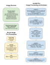
1760228167402.png

Results​

Using ArcGIS Pro’s geometry attributes tool, the total Area of Interest (AOI) was measured at 680,191.4 m² (68 ha). Riparian vegetation coverage was then calculated for pre-fire and post-fire datasets:

  • Pre-fire (May 5, 2022): 167,520.2 m² (16.8 ha), representing 24.6% of the AOI
  • Post-fire (October 6, 2025): 122,606.6 m² (12.3 ha), representing 18.0% of the AOI
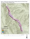
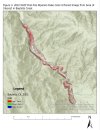
The comparison indicates a loss of 44,916.6 m² (4.5 ha) of riparian habitat (pre-fire - post-fire), equivalent to a 26.8% decline [((post-fire - pre-fire) / post-fire) x 100%] in total riparian vegetation cover within the study reach. Figures 3 and 4 show the resulting 2022 NAIP Pre-fire and 2025 Drone Post-fire orthophoto maps within the AOI.

1760228417126.jpeg

1760228430244.jpeg
 
Last edited:
My air 2s is the greatest ever I have flown it way past its life expectancy and then some and it still flies like I just took it out of the box !
 
  • Like
Reactions: AMann
Naw, my Dad was an engineer though. I am a retired teacher and wildlife biologist, but I still like to do projects and love playing with GIS and making maps with my drone! Plus, I like doing volunteer projects with it - of which this was one for the Forest Service and my final project in my GIS class (I'm taking some GIS classes for fun also).
Thanks for the compliments, though!

-Anthony
 
Thank you for sharing. I recently picked up an IR Chrome filter for my M2P as well to use for photography, but with all the fires we’ve had in southern Oregon I may get a chance to try this too.
 
  • Like
Reactions: AMann and Ted B
I have been using my IR-modified Mavic 2 Pro to do vegetation monitoring on a local National Forest (US). I did the IR conversion myself using Kolarivision directions, which was very easy! I used their IR Chrome filter to produce false color infrared images of the riparian vegetation growing along a creek. The purpose of the study was to determine the amount of recovery after a wildfire swept through the area back in 2022. Note: The Kolari IR Chrome filter is not calibrated to do NDVI vegetation index work, so I used the red (IR) band to only detect coverage in the images. Kolari's Blur IR filter is appropriate for doing NDVI crop health surveys.

Here is a description of the workflow, and some results for the process (It is OK to share these files):

A DJI Mavic 2 Pro drone, equipped with an infrared-modified camera and KolariVision IR Chrome filter, was manually flown at 120 meters AGL (the maximum legal altitude). Approximately 240 overlapping images (25% overlap) were captured along the riparian corridor. The IR Chrome filter passes blue and green wavelengths (around 470-550nm) and longer infrared wavelengths (720nm and up), which combine to produce a false color infrared image that highlights vegetated areas.

Post-processing involved generating a false color infrared orthomosaic (GeoTIFF) using Adobe Bridge, WebODM, and QGIS. Pre-fire NAIP imagery and the processed post-fire orthophoto were imported into ArcGIS Pro for georeferencing, image classification, and area calculations. Figure 2 outlines the workflow used for image processing and analysis.
View attachment 185793

Results​

Using ArcGIS Pro’s geometry attributes tool, the total Area of Interest (AOI) was measured at 680,191.4 m² (68 ha). Riparian vegetation coverage was then calculated for pre-fire and post-fire datasets:

  • Pre-fire (May 5, 2022): 167,520.2 m² (16.8 ha), representing 24.6% of the AOI
  • Post-fire (October 6, 2025): 122,606.6 m² (12.3 ha), representing 18.0% of the AOI
The comparison indicates a loss of 44,916.6 m² (4.5 ha) of riparian habitat (pre-fire - post-fire), equivalent to a 26.8% decline [((post-fire - pre-fire) / post-fire) x 100%] in total riparian vegetation cover within the study reach. Figures 3 and 4 show the resulting 2022 NAIP Pre-fire and 2025 Drone Post-fire orthophoto maps within the AOI.

View attachment 185794

View attachment 185795
I have had a MP2 for a number of years and have not stopped having new uses for it. Great to use with my M3T.
 

DJI Drone Deals

New Threads

Members online

Forum statistics

Threads
138,946
Messages
1,642,837
Members
167,278
Latest member
dangerd
Want to Remove this Ad? Simply login or create a free account