Surge
Well-Known Member
- Joined
- Apr 22, 2018
- Messages
- 96
- Reactions
- 47
- Age
- 51
It certainly is not. I'm a commercial pilot. See my point just above this.This is bad information and should not be taken into consideration
It certainly is not. I'm a commercial pilot. See my point just above this.This is bad information and should not be taken into consideration
You should be aware that some of the people posting here are quite familiar with those rules.
Exactly my point @tleedom - you said it better than me:
"An altitude of 500 feet above the surface except over open water or sparsely populated areas. In that case, the aircraft may not be operated closer than 500 feet to any person, vessel, vehicle, or structure."
Your previous post points out that there is no minimum altitude requirement for manned airplanes in sparsely populated areas. They can legally fly below 400' AGL in such areas.It certainly is not. I'm a commercial pilot. See my point just above this.
So your are saying that is not the UAS pilots responsibility to avoid manned aircraft?It certainly is not. I'm a commercial pilot. See my point just above this.
It's the app that showed me the helicopter at 500-something feet and climbingThat helicopter looks no where near close to 500'. I used to worry about stuff like that with both helicopters and planes and thinking they were a lot lower than they actually were. Then I got a flight aware premium subscription to get actual altimeter altitude and I'd notice that helicopters that I was worried about with low altitudes were actually flying at more like 1'200. When a helicopter is at 500', you'd absolutely know it
It's the app that showed me the helicopter at 500-something feet and climbing
Pretty cool to watch them fly through that canyon. They have a similar canyon in the UK.
It IS the UAS pilot's responsibility. See the regulation cited in post #43.So your are saying that is not the UAS pilots responsibility to avoid manned aircraft?
The Mach Loop (in the video) IS in the UK - in Wales!Pretty cool to watch them fly through that canyon. They have a similar canyon in the UK.
Max cruise airspeed on a 172 is 124 kts. Max airspeed is 163 kts. So, at cruise the drone would have to be going 67 mph at 180 degrees to your course to have that closing speed. My Mavic 3 tops out at 47 mph. What are you flying?I wonder how good it feels to have right of way in your cessna 172 or Ft Lewis blackhawk, while a drone comes through your windshield at 210 MPH?
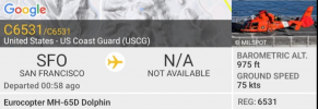
It absolutely was 500-something feet when I first checked Flightradar24, and ascending fast. By the time I managed to take a screen snapshot on my mobile phone it had ascended to 975 feet.That helicopter looks no where near close to 500'. I used to worry about stuff like that with both helicopters and planes and thinking they were a lot lower than they actually were. Then I got a flight aware premium subscription to get actual altimeter altitude and I'd notice that helicopters that I was worried about with low altitudes were actually flying at more like 1'200. When a helicopter is at 500', you'd absolutely know it


It absolutely was 500-something feet when I first checked Flightradar24, and ascending fast. By the time I managed to take a screen snapshot on my mobile phone it had ascended to 975 feet.
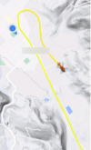
View attachment 165182
According to What is my elevation?, my elevation is 443 feet. What insight does that give you into the accuracy of the reading?How does FlightRadar24 define barometric altitude? I'm unable to find an answer, but it's not instantaneous AGL altitude. I'm guessing it's standard altitude based on 29.92 in Hg. If your local elevation is significant, the helo could have been very low to the ground, even with the 975' barometric altitude as illustrated.
How is elevation calculated?
Using an Altimeter
An altimeter is an instrument used to measure altitude. Altitude is measured with an altimeter by calculating differences in atmospheric pressure. Inside of an altimeter is a barometer which is a device that measures pressure in the air. As you travel upwards, the pressure decreases which causes the bellows inside the barometer to expand.
The information on FliteRadar24's website on that altitude reading is useless in figuring it out. Barometric altimeters need to be set to a reference pressure. Above 18,000' the FAA says to use standard barometric pressure, 29.92 in hg. For local flights, it's usually set to whatever value makes the airplanes altitude 0' when it's on the ground at the airport.According to What is my elevation?, my elevation is 443 feet. What insight does that give you into the accuracy of the reading?
According to their website:
I just skimmed through the FAAs' Barometric Altimeter Errors and Setting Procedures and would assume the barometer was calibrated properly. It does seem strange to me that the reading was 500-something feet because you're right, it would be crashing into trees. It was quite low though. The reading of 975 feet in my screenshot minus my altitude of 443 feet would give an absolute altitude in the 500s of feet. Maybe it was really low when I saw the reading in the 500s but I don't remember whether it was 501 or 599 feet. If it was closer to 599 feet, and I'm at 443 feet, it would have been 160ish feet absolute altitude, which could well be possible. It was really loud and low.The information on FliteRadar24's website on that altitude reading is useless in figuring it out. Barometric altimeters need to be set to a reference pressure. Above 18,000' the FAA says to use standard barometric pressure, 29.92 in hg. For local flights, it's usually set to whatever value makes the airplanes altitude 0' when it's on the ground at the airport.
Fliteradar24 just says that the altitude is whatever is reported by the aircraft's ADS-B transponder. I'm not familiar enough with ADS-B to know what barometric reference they use.
If you're standing at 443' MSL, and airplane reporting its altitude as 448' MSL flew over, it would hit you square in the face.
I'm really curious about what the Fliteradar24 barometric altitude readings really represent. Anyone? Any current Part 61 pilots know?
We use essential cookies to make this site work, and optional cookies to enhance your experience.


