

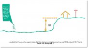
When making a waypoint mission and you start at a higher elevation, would you have waypoint elevations based off of the takeoff elevation? I realized that my elevations for each waypoint seemed too low. It showed 70 ft. on the first waypoint and my guess would have been 100 or so. My question is..... Will the drone be flying the way point at 70' or 100' where I assumed it would be. 70 ft. would be close to skimming trees. Hope this make sense. See attached image:

Way Point elevations
- Thread starter RadarDave
- Start date

Similar threads


DJI Drone Deals
New Threads
-

-
 2 Genuine DJI Mini 4 Pro, Mini 3 Series Plus Intelligent Flight Battery
- Started by Dogpilot
- Replies: 0
-

-
 Mini 4 Pro Istanbul where the East meets West - Eminönü
- Started by MPone
- Replies: 1
-
 Wanting to understand "Power Banks" and what I'll need....
- Started by MavicFlyer2
- Replies: 6