DJI Mavic, Air and Mini Drones
Friendly, Helpful & Knowledgeable Community
Join Us Now

Waypoint flights, some questions.

Okay, I think I get what @jephoto is getting at. Check out this mockup... Is this the idea? the green translucent arc shows what will be in frame (not exact, 90° rather than 81 'cause the drawing app wanted to snap to common angles) for a level, 0° tilt gimbal.

This could easily be dynamic, narrowing the angle if zoom is employed (useful for video, not so much stills).

Another feature that actually would be pretty simple to add. Maybe we should suggest to DJI?
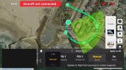
1000016855.jpg
 
Sorry, I didn’t see this right after you posted. But yes, this is exactly what I was asking about. A simple visual representation of the cameras angle of view from a given waypoint.
And again, the answer to my original question was,” No, it doesn’t do that- “yet. But it would be helpful…
 
Prompted by a recent thread, I haven't flown a waypoint flight nor have I tried to program one, I don't even know if my drones are capable of them. I don't think I ever will fly one but the thread made me wonder about some aspects of them.
Qu 1, speed, can the drone's speed be changed for each leg? I.e. could it be 5m/s between points 1 & 2, 10m/s between points 2 & 3, 7m/s between 3 & 4 .........?
Qu 2, are flight-mode speed limitations applicable? Meaning, is the flight flown in one of the three flight-modes, cine, normal, sports or in a 'waypoint' flight mode.
Qu 3, where do changes in height take place?
Qu 4, where do turns take place and are they smooth turns?
Great question. I have the Mavic 2 Pro and use waypoints.
1. In normal mode, you'll access the Waypoints Intelligent Flight mode by tapping the 'flight controller' icon on the left side of the screen, which will bring up a menu to select your preferred Intelligent Flight mode -in this case, Waypoints. Once there, you will have the ability to create waypoints. Once the waypoints have been created, you have the ability to specify a crossing speed for each waypoint.
2. normal
3. prior to reaching the waypoint. The drone will cross the waypoint at the pre-programmed crossing altitude.
4. You have 2 choices for how the drone will turn when approaching or reaching the waypoint. One choice is 'arc', which will allow the drone to take a 'shortcut' at the waypoint in a nice smooth arc. Otherwise, without 'arc' set, the drone will turn abruptly at the waypoint to head for the next waypoint.
You can flight plan and store your route at home if you wish and call it up upon arrival at the flight location.
 
Great post, @KLJ5!

I'd add that the Mavic 2 has fully exposed autonomy in the SDK, so Litchi is another – better in the opinion of many – option for waypoint operations, with the same uploaded flight plan executed autonomously by the Mavic 2.
 
Ahhhh. This is the use case where the Mavic 2 Pro with Litchi beats the pants off anything DJI is selling today. The Mavic 2 Pro is a workhorse and has yet to be equalled in this arena.
AMEN to that.... I honestly think that the mav 2's were the last completely rounded and 'fully loaded' drones DJI released. There would have to be catastrophic failures before I'd even think once about replacing them.
 
  • Like
Reactions: PHZ
AMEN to that.... I honestly think that the mav 2's were the last completely rounded and 'fully loaded' drones DJI released. There would have to be catastrophic failures before I'd even think once about replacing them.
I sure agree with that, but at the risk of going off topic, what about the aging Mavic 2 batteries?
 
  • Like
Reactions: Felix le Chat
I am going to add an additional question, are the actual waypoints
1) a set of fixed Lat & Long points
or
2) a set of calculated Lat & Long points such that each of the waypoints will end up being on the same bearing and at the same distance from the take off point as in the original 'flight' ?
e.g.
the coridinates of wp1 are such that wp1 is 100yds NW of the take off point,
the coridinates of wp2 are such that wp2 is 200yds S of the take off point,
the coridinates of wp3 are such that wp3 is 50yds W of the take off point,
the coridinates of wp4 are such that wp4 is 75yds Eof the take off point ..... etc. etc. etc..

1) would mean that if someone were to re-use a plan but launch 20 miles from the original take of point the drone is going to have a very long flight to the first waypoint.

2) Would make more sense to me but means the drone or something probably has to do a fair bit of calculation.
 
Last edited:
  • Like
Reactions: jephoto
I am going to add an additional question, are the actual waypoints
1) a set of fixed Lat & Long points
or
2) a set of calculated Lat & Long points such that each of the waypoints will end up being on the same bearing and at the same distance from the take off point as in the original 'flight' ?
e.g.
the coridinates of wp1 are such that wp1 is 100yds NW of the take off point,
the coridinates of wp2 are such that wp2 is 200yds S of the take off point,
the coridinates of wp3 are such that wp3 is 50yds W of the take off point,
the coridinates of wp4 are such that wp4 is 75yds Eof the take off point ..... etc. etc. etc..

1) would mean that if someone were to re-use a plan but launch 20 miles from the original take of point the drone is going to have a very long flight to the first waypoint.

2) Would make more sense to me but means the drone or something probably has to do a fair bit of calculation.
1) a set of fixed Lat & Long points
 
  • Love
Reactions: Yorkshire_Pud
Thanks but
Eek, that severely curtails the usability of a plan, doesnt it ?
I have flown 100s if not 1000s of waypoint missions. While I cannot speak for everyone else, I can say with confidence that with few exceptions, all of my waypoint missions are designed on a map for a specific purpose at a specific location. With that in mind, it wouldn't make sense for the mission to alter any of its waypoint coordinates based on where I happen to be standing (take-off location) when the drone takes off.

I'm curious what type of waypoint flight are you imagining where you would like the waypoint coordinates to be relative to your take-off location?
 
  • Like
Reactions: Yorkshire_Pud
I have flown 100s if not 1000s of waypoint missions. While I cannot speak for everyone else, I can say with confidence that with few exceptions, all of my waypoint missions are designed on a map for a specific purpose at a specific location. With that in mind, it wouldn't make sense for the mission to alter any of its waypoint coordinates based on where I happen to be standing (take-off location) when the drone takes off.

I'm curious what type of waypoint flight are you imagining where you would like the waypoint coordinates to be relative to your take-off location?
The question stemmed from threads where the pilot set up a waypoint flight whilst well above a lake, the flight included a low level section over the lake. The pilot then repeated the flight taking off from the lake's shore. I wondered if the waypoints had shifted in accordance the pilots move.

I doubt I will ever fly a way point flight myself, they just do not appeal to me.
 
The question stemmed from threads where the pilot set up a waypoint flight whilst well above a lake, the flight included a low level section over the lake. The pilot then repeated the flight taking off from the lake's shore. I wondered if the waypoints had shifted in accordance the pilots move.
That is a different situation from your response in post #29. The height of the waypoints are always relative the the ground elevation at the take-off location. If you fly a second mission, taking off from a lower elevation, all waypoint heights will be relative to your new take-off elevation. The GPS coordinates themselves, will not change if you move laterally with lateral changes in the take-off location.
 
Since watpoint missions are almost always for the purpose of capturing images or video of their specific locations, it makes little sense to transfer a mission to another location. The waypoint feature includes POI designation that the camera can be focused on, integral to the feature.

Obviously a POI at one location isn't likely to be one somewhere else the entire plan is translated to.
 
That is a different situation from your response in post #29. The height of the waypoints are always relative the the ground elevation at the take-off location. If you fly a second mission, taking off from a lower elevation, all waypoint heights will be relative to your new take-off elevation. The GPS coordinates themselves, will not change if you move laterally with lateral changes in the take-off location.
We will have to disagree on that. To my mind it involved a change of location so, as of post 27, the question about the horizontal positioning aspect still applied. Overall the flight plan was not suitable for the second location.
 
We will have to disagree on that. To my mind it involved a change of location so, as of post 27, the question about the horizontal positioning aspect still applied. Overall the flight plan was not suitable for the second location.

Waypoint missions are not altitude-relative by design, but by limitation. The lack of a calibrated altimeter simply makes it impossible to accurately record and replay a precise altitude. It's not the desired behavior for waypoint flights.

I've wondered from the beginning of my use of Litchi a decade ago why DJI doesn't provide some advanced features that require accepting a bunch of warnings first to get access to, similar to enabling Manual mode on the fpv models.

One of the advanced features would be to precisely calibrate the barometric altimeter. Another might be to use GPS altitudes, where it's accurate enough for the mission.
 
We will have to disagree on that.
To what are you disagreeing?

To my mind it involved a change of location so, as of post 27, the question about the horizontal positioning aspect still applied. Overall the flight plan was not suitable for the second location.
In post #27 you are asking about how a change in lateral position of the take-off location affects the mission. It doesn't.

The rest of this thread (and in your post #22) is referring to a change in height of the take-off location.

Those are two different things and the behavior between them is unrelated -- one by design (GPS) and one by limitation (height). One needs to separate the two when discussing a change in take-off location.
 
Last edited:
To my mind they are inter connected, the change in launch point could have resulted in the drone taking a swim and having a multi mile flight to the first way point etc..

Well, you can launch from a different location and, as long as it's at the same elevation and there is sufficient battery to reach the first waypoint, and return after the mission, it will fly the waypoint portion of the flight exactly the same.

This isn't as theoretical as one might think. There are plenty of regions where altitude is pretty constant and flat for hundreds of square kilometers. In any case, if one needs to launch from a different area relatively near by, it's pretty easy to find a spot at the right elevation. Done it with Litchi.
 
To my mind they are inter connected
They may be interconnected in your mind but in reality they are not.
the change in launch point could have resulted in the drone taking a swim
Yes, that is true if the launch point changed to a lower altitude. All heights will be relative to that lower altitude.
and having a multi mile flight to the first way point etc
Yes, that is true if the launch point is laterally changed to be miles away. However, the implementation of waypoints usually includes a maximum allowable distance from the take-off location to the first waypoint. For example, in Litchi the maximum allowable distance between take-off and waypoint #1 is 4000m -- still a pretty long distance.

The point I am trying to make is that a change in height and a change in location of the take-off location of a waypoint mission each have a different effect on the flight. One may cause the drone to fly higher or lower (or even crash into the water) during a mission. The other will not affect the mission itself. Instead it will only change the lateral distance between the take-off location and waypoint #1.

We may be arguing semantics. Sure, everything is "inter-connected". Everything we are talking about is related to drones and waypoint missions. However, to be proficient at planning and flying waypoint missions, one really needs to know the difference between the affect a change in height of the take-off location has (could be disastrous) and the affect a change in lateral location has (typically no affect).
 

DJI Drone Deals

New Threads

Forum statistics

Threads
134,749
Messages
1,598,169
Members
163,246
Latest member
Dome7768
Want to Remove this Ad? Simply login or create a free account