DJ Wes
Well-Known Member
I have analyzed your mission and your flight path. Your mission lies primarily along a very long, straight line. Waypoint 4 creates a sharp turning point where the drone changes direction 180 degrees. Up until waypoint 4 the drone was traveling away from you. After waypoint 4 the drone is traveling back to you.It was a nightmare to get out the kmz file but I've managed it. Here's the waypoint kmz. I already shared the flight log and screenshots in the previous message. The mission looks normal to me. Let me know if you uncover anything. Thanks!
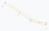
Here is a side view of your mission. This drawing was created using your waypoints and a Centripetal Catmull-Rom spline with a tension/alpha value of 0.5 (my best guess as to what DJI uses):

If one zooms in on the area around waypoint 4 you will see this:

I may not be using the same tension/alpha parameters for the spline that DJI uses. That would affect how the spline (flight path) would be created either side of waypoint 4. In any case, notice that the flight path shown in red is traveling below a straight line connecting waypoints 3 and 4 (shown in yellow).
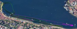
Here is a view of your waypoints (white), a Litchi flight path made from your waypoints (magenta), and your actual flight path from the logs you provided (green):

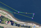
Notice how the actual flight path (green) is veering away from what would have been the Litchi flight path between waypoints 3 and 4 in order to negotiate the sharp turn created by waypoints 3, 4, and 5. I understand that Litchi has nothing to do with your flight. I am only using that as a comparison.
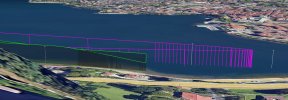
This side view also shows how the DJI flight path is getting lower in order to negotiate passing through waypoints 4 (at the end) and 5 (the way back):

In my opinion, your waypoints 3, 4, and 5 are creating a tricky situation where DJI's flight path passes through each waypoint necessitating a flight path that curves well outside of the bounding box defined by the waypoints.
My recommendation would be to experiment (in a safe area) with a smaller version of this mission where you do not have such an abrupt change in direction at the end of a long flight path like this.
I hope this helps to understand what happened with this mission.


