DJI Mavic, Air and Mini Drones
Friendly, Helpful & Knowledgeable Community
Join Us Now

Waypoint Mission (IMPOSSIBLE) !!!!! 🇦🇮🦘

It was a nightmare to get out the kmz file but I've managed it. Here's the waypoint kmz. I already shared the flight log and screenshots in the previous message. The mission looks normal to me. Let me know if you uncover anything. Thanks!
I have analyzed your mission and your flight path. Your mission lies primarily along a very long, straight line. Waypoint 4 creates a sharp turning point where the drone changes direction 180 degrees. Up until waypoint 4 the drone was traveling away from you. After waypoint 4 the drone is traveling back to you.

Here is a side view of your mission. This drawing was created using your waypoints and a Centripetal Catmull-Rom spline with a tension/alpha value of 0.5 (my best guess as to what DJI uses):
Capture.PNG
If one zooms in on the area around waypoint 4 you will see this:
Capture.PNG
I may not be using the same tension/alpha parameters for the spline that DJI uses. That would affect how the spline (flight path) would be created either side of waypoint 4. In any case, notice that the flight path shown in red is traveling below a straight line connecting waypoints 3 and 4 (shown in yellow).

Here is a view of your waypoints (white), a Litchi flight path made from your waypoints (magenta), and your actual flight path from the logs you provided (green):
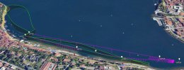
Capture.JPG
Notice how the actual flight path (green) is veering away from what would have been the Litchi flight path between waypoints 3 and 4 in order to negotiate the sharp turn created by waypoints 3, 4, and 5. I understand that Litchi has nothing to do with your flight. I am only using that as a comparison.

This side view also shows how the DJI flight path is getting lower in order to negotiate passing through waypoints 4 (at the end) and 5 (the way back):
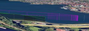
Capture.JPG

In my opinion, your waypoints 3, 4, and 5 are creating a tricky situation where DJI's flight path passes through each waypoint necessitating a flight path that curves well outside of the bounding box defined by the waypoints.

My recommendation would be to experiment (in a safe area) with a smaller version of this mission where you do not have such an abrupt change in direction at the end of a long flight path like this.

I hope this helps to understand what happened with this mission.
 
I have analyzed your mission and your flight path..

Wow, I appreciate the time you put into this. Thank you.

My primary goal is to run fully autonomous flights where the drone starts from my location, runs the mission, and returns to me. I prefer doing the takeoff and landing manually as it's a challenging lakeside spot. But ideally once the drone is in the air I never have to touch controls again until it's back to where I am, ready to land. I do not want to use RTH because that would mean the drone will fly over people and cars due to the shape of the lakeside. It would also need to go higher than what that area permits to make sure it clears all obstacles. So not a feasible option.

Based on the insights you shared, it seems I have 2 options to accomplish this:

1) Have 2 separate waypoint missions. One for going all the way to the bridge, another one for returning to me. That way the path wouldn't curve as all waypoints would be linear in each waypoint file. I would need to manually activate the second waypoint mission once the drone is at the waypoint farthest from me.

2) As you said, try to remake the file by doing multiple waypoint tests until I find a curve that doesn't bend.

I like the cinematic curve algorithm idea that DJI is going with, but the undisclosed and unmitigated altitude behaviour imo is a serious oversight by them. I should be able to see min/max altitude on a waypoint file and also be able to set min/max altitude that will override and modify the drone path. This seems like an obvious feature to include considering no min altitude means drone might run into obstacles, and no max altitude means drone could break the law by going above the permitted altitude in the area it operates in.

Thanks again for your help.
 
1) Have 2 separate waypoint missions. One for going all the way to the bridge, another one for returning to me. That way the path wouldn't curve as all waypoints would be linear in each waypoint file. I

What about adding one or more waypoints between the end of the outward bound leg and the homeward bound leg that do nothing but pause the drone and rotate it toward the home point?
 
I would need to manually activate the second waypoint mission once the drone is at the waypoint farthest from me.
I prefer to have missions that will bring the drone back to me without any manual input from me. Here is how I would adjust your mission:

Capture.PNG

When using DJI Fly, it would look like this (red path):
Capture.PNG
Keep all of the waypoint heights the same around WP3, WP4, WP5, WP6. Then, there will be no reason for the drone to travel lower (or higher) at the far end of your mission.
 
Last edited:
  • Like
Reactions: GadgetGuy

DJI Drone Deals

New Threads

Forum statistics

Threads
136,589
Messages
1,619,124
Members
165,230
Latest member
Esteemed
Want to Remove this Ad? Simply login or create a free account