

I would like to use Waypoints for go back to the exact location several times so I can take the same photo on different days (daylight, sunset, night). So, I would like to create one Waypoint where the drone goes there and hovers. Is this possible. OR, is there another way to find the same spot, or at least get close?
You are using an out of date browser. It may not display this or other websites correctly.
You should upgrade or use an alternative browser.
You should upgrade or use an alternative browser.
Waypoints for photography
- Thread starter Duncan McCall
- Start date
@Duncan McCall as long as you can find a way to mark the exact location ,so you can replicate the flight once airborne,the results will be pretty accurate ,of course the weather ,such as wind, and barometric pressure, will have a small influence ,on the positioning accuracy, of indevidual flights,
mobilehomer
Well-Known Member
I have tried this and found I needed two waypoints minimum to be a mission. Fly to your location, set the heading, gimbal, camera settings and action to take a picture. Then move a few feet and set a new waypoint with no camera action. RTH at end of mission. Make sure to take off from the exact same place if possible.
Ahhh. Good point. I can create a 2-point mission and just cancel the flight when it gets to the second point. Brilliant.I have tried this and found I needed two waypoints minimum to be a mission. Fly to your location, set the heading, gimbal, camera settings and action to take a picture. Then move a few feet and set a new waypoint with no camera action. RTH at end of mission. Make sure to take off from the exact same place if possible.
I think that is my point - How do you mark the exact location? I'm looking for 'pretty accurate'. I can manipulate it in photoshop to get them to match up.@Duncan McCall as long as you can find a way to mark the exact location ,so you can replicate the flight once airborne,the results will be pretty accurate ,of course the weather ,such as wind, and barometric pressure, will have a small influence ,on the positioning accuracy, of indevidual flights,
izometric
Well-Known Member
I tried to do that with Air3. I set several waypoint, with a hover time of 4 seconds. The problem is that the drone takes a shot the moment it reaches the waypoint and then hovers for 4 seconds.
So what I did, was to set a way point to location, hover for 2 seconds + do nothing, then an identical waypoint, hover for 2 seconds + take photos.
The result is that the drone goes to the location, hovers for 2 seconds, takes a photos, hovers another 2 seconds and then moves to the next location.
So what I did, was to set a way point to location, hover for 2 seconds + do nothing, then an identical waypoint, hover for 2 seconds + take photos.
The result is that the drone goes to the location, hovers for 2 seconds, takes a photos, hovers another 2 seconds and then moves to the next location.
One more question. Once it gets to the desired location (either #1 or #2), can't I pause the flight so the drone will be hovering-in-place and I can just take over from there? Thanks for the info. I'll be testing it soon.I tried to do that with Air3. I set several waypoint, with a hover time of 4 seconds. The problem is that the drone takes a shot the moment it reaches the waypoint and then hovers for 4 seconds.
So what I did, was to set a way point to location, hover for 2 seconds + do nothing, then an identical waypoint, hover for 2 seconds + take photos.
The result is that the drone goes to the location, hovers for 2 seconds, takes a photos, hovers another 2 seconds and then moves to the next location.
izometric
Well-Known Member
As far as I was able to see, there is a pause button on the screen that when pressed, the drone will continue to the next waypoint. But either way, say it doesn't, with a push of a button you can relaunch the mission from the specified waypoint. Say you have a 50 waypoint mission, you can chose to start at 45 and do only the last 5 waypoints.
With the risk of being too simplistic, here's another thought. When near your chosen vantage point and altitude, aim the camera 90 degrees downward and zoom in fully. Find a recognizable, non-movable position aiming point (corner of a building, manhole cover, ...) and maneuver the drone to put the center-of-frame marker over it. Note the altitude and the aiming point. Rotate the drone and tilt the gimbal to compose your shot and note another aiming point at the center of the frame. Or note the drone azimuth and gimbal tilt angle. Return and re-shoot as desired.
Would repeating the shots with that method give you adequate precision to align photos taken over time?
Would repeating the shots with that method give you adequate precision to align photos taken over time?
Last edited:
izometric
Well-Known Member
The drone is not showing the AGL at the waypoint. It is showing the altitude relative to the take-off point.
So you can record all you want, if the take off point is at different altitudes, the drone will be reporting the same AGL all the time. If you are off by one meter it shows in post, There will be a jump in the frame.
So you can record all you want, if the take off point is at different altitudes, the drone will be reporting the same AGL all the time. If you are off by one meter it shows in post, There will be a jump in the frame.
Why would he be taking off from different elevations if he is repeating the same flight and also launching from the same location? All waypoint flights require launching from the same location, or at least from the identical elevation, which is much harder to achieve, unless on flat level ground, without any change in terrain. They are designed to be flown identically.The drone is not showing the AGL at the waypoint. It is showing the altitude relative to the take-off point.
So you can record all you want, if the take off point is at different altitudes, the drone will be reporting the same AGL all the time. If you are off by one meter it shows in post, There will be a jump in the frame.
As long as the takeoff site is the same.With the risk of being too simplistic, here's another thought. When near your chosen vantage point and altitude, aim the camera 90 degrees downward and zoom in fully. Find a recognizable, non-movable position aiming point (corner of a building, manhole cover, ...) and maneuver the drone to put the center-of-frame marker over it. Note the altitude and the aiming point. Rotate the drone and tilt the gimbal to compose your shot and note another aiming point at the center of the frame. Or note the drone azimuth and gimbal tilt angle. Return and re-shoot as desired.
Would repeating the shots with that method give you adequate precision to align photos taken over time?
izometric
Well-Known Member
Monday to Friday I am launching from a second floor terrace just in front of my office. (I'm shooting something for the company I work for)
Saturday-Sunday I do not have access to that terrace on the second floor. The entire building is locked and alarmed.
Is this answering your question?")
Saturday-Sunday I do not have access to that terrace on the second floor. The entire building is locked and alarmed.
Is this answering your question?
The drone is not showing the AGL at the waypoint. It is showing the altitude relative to the take-off point.
So you can record all you want, if the take off point is at different altitudes, the drone will be reporting the same AGL all the time. If you are off by one meter it shows in post, There will be a jump in the frame.
Or, you can account for the difference in the elevation of the takeoff points. Very straightforward. Fly from the balcony to your weekend takeoff point, or vice versa, and note the difference.
izometric
Well-Known Member
I am not planing to use topometry equipment to determine the altitude level between different take off points.
It would be nice if DJI would give an option to convert the waypoints location into absolute values, measured from the sea level. I mean the satellites provide this kind of information.
It would be nice if DJI would give an option to convert the waypoints location into absolute values, measured from the sea level. I mean the satellites provide this kind of information.
izometric
Well-Known Member
and note the difference.
What difference?
One more time, the drone is not showing different altitudes depending where you take off from. It will just fly higher or lower, showing the same altitude, relative to the take off point, on the screen.
Last edited:
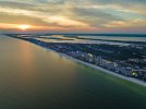
I'm shooting from a beach, so I will have access to the same launch site. I want to shoot shots like this at sunset and then after sunset when the lights come on. Then overlay the 2 photos. This (attached photo) is an attempt using all the information I had to get it close. I matched altitude and distance and even drew a line in the sand pointing towards the location of the drone so I could sight it in. I had to do a lot of tweaking to match the 2 photos. I would love to just hit a waypoint and send the drone to the same position. Still playing with it. Maybe a sextantMonday to Friday I am launching from a second floor terrace just in front of my office. (I'm shooting something for the company I work for)
Saturday-Sunday I do not have access to that terrace on the second floor. The entire building is locked and alarmed.
Is this answering your question?
Attachments
That's right. The best I can do at this point is to get it in the general same direction (like SSE) from my launch point, then match the altitude and distance from launch (435ft altitude & 3250ft distance) and try to visually match it up. I wish I could just 'push a button' and it would go there.What difference?
One more time, the drone is not showing different altitudes depending where you take off from. It will just fly higher or lower, showing the same altitude, relative to the take off point, on the screen.
In this specific case, I'm shooting over water. BUT, that would work in cityscapes. For the beach shots (over water), I might could zoom in on 2 points on land and line them up. I'm only shooting about 30 minutes apart (too long to hover on 1 battery) so the 2 points would be fresh and easy to find. It's not like I'm coming back weeks later. Hmmmmm. Good idea.With the risk of being too simplistic, here's another thought. When near your chosen vantage point and altitude, aim the camera 90 degrees downward and zoom in fully. Find a recognizable, non-movable position aiming point (corner of a building, manhole cover, ...) and maneuver the drone to put the center-of-frame marker over it. Note the altitude and the aiming point. Rotate the drone and tilt the gimbal to compose your shot and note another aiming point at the center of the frame. Or note the drone azimuth and gimbal tilt angle. Return and re-shoot as desired.
Would repeating the shots with that method give you adequate precision to align photos taken over time?
What difference?
One more time, the drone is not showing different altitudes depending where you take off from. It will just fly higher or lower, showing the same altitude, relative to the take off point, on the screen.
Edit: It's a bit confusing that there are two discussions of the same topic, with izometric and the OP.
---------------------
Of course, the indicated altitude is relative to the takeoff point. You have two takeoff points with a constant altitude difference between them. It's very easy to fly the drone to the same absolute altitude from both.
- Set the balcony as your base point and set your altitude relative to there.
- Fly from your weekend point (at lower elevation) to the balcony. Note the elevation difference, i.e. your indicated altitude with the drone at the balcony takeoff elevation.
- For balcony flights, use your base point indicated altitude. For weekend flights, fly the drone to an indicated altitude equal to your balcony base point altitude plus the elevation difference.
Last edited:
Similar threads
- Replies
- 5
- Views
- 432
- Replies
- 4
- Views
- 419
- Replies
- 2
- Views
- 1K
- Replies
- 5
- Views
- 407


DJI Drone Deals
1. Mini 2
2. Mini 3 Pro
3. Mini 4 Pro
4. Air 2s
5. Air 3
6. Avata 2
7. Mavic 3 Pro
8. Mavic 3 Classic
2. Mini 3 Pro
3. Mini 4 Pro
4. Air 2s
5. Air 3
6. Avata 2
7. Mavic 3 Pro
8. Mavic 3 Classic
Forum statistics
