DJI Mavic, Air and Mini Drones
Friendly, Helpful & Knowledgeable Community
Join Us Now

Why doesn't a drone use GPS for legal height rather than home point height

Thats incorrect, taking off from B would put the drone at 500ft, taking off from A would put the drone at 100ft,
The drone sets the height to zero from take off point hence why you can still fly at 400 ft max from point A
There's nothing incorrect about what I posted.
What is incorrect is your uninformed statement that "the max height allowed is taken from zero feet at point of take off".
My artwork was to make it obvious that such a system makes no sense at all.
What matters is how high your drone is above the ground below it and where you launch from is completely irrelevant.

It's amazing that someone who's been a member for 7 years hasn't understood this very basic fact.
 
Thats incorrect, taking off from B would put the drone at 500ft, taking off from A would put the drone at 100ft,
The drone sets the height to zero from take off point hence why you can still fly at 400 ft max from point A

The altitude number on the screen has no meaning or significance in any drone regulation.

The basic altitude limit is very straightforward - at all times, the done must be within 400 feet of the ground directly below it.
 
  • Like
Reactions: Meta4
Thats incorrect, taking off from B would put the drone at 500ft, taking off from A would put the drone at 100ft,
The drone sets the height to zero from take off point hence why you can still fly at 400 ft max from point A
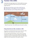
Flying up the side of a mountain(at a prescribed maximum distance from the mountain which I don't recall)you can exceed the 400' from takeoff as you are not over 400' above the mountainside you are ascending.You could in theory be 12,000 ft above sea level and still be compliant.
 
Flying up the side of a mountain(at a prescribed maximum distance from the mountain which I don't recall)you can exceed the 400' from takeoff as you are not over 400' above the mountainside you are ascending.You could in theory be 12,000 ft above sea level and still be compliant.
DJI has flown a drone over Mt. Everest. Any altitude is fine as long as there's ground no more than 400' directly below the drone.
 
I believe in the UK the rule says you are only allowed to fly 400 feet above the take off point...regardless; but I could be wrong.
 
I believe in the UK the rule says you are only allowed to fly 400 feet above the take off point...regardless; but I could be wrong.
The requirement to remain below 400 feet (120 m) above the ground level directly below the drone is the same in the UK and the US.


Screenshot 2024-07-21 130407.jpg
 
DJI has flown a drone over Mt. Everest. Any altitude is fine as long as there's ground no more than 400' directly below the drone.
This seems clear-"So if there’s a 1,200 ft. telecommunications tower, you can inspect it with your UAS, as long as you’re flying within 400 ft. of the tower both horizontally and above its highest point at all times. If flying above a structure means you will be entering controlled airspace, be aware of that fact and follow air traffic control (ATC) procedures, which we cover in other lectures."
 
This seems clear-"So if there’s a 1,200 ft. telecommunications tower, you can inspect it with your UAS, as long as you’re flying within 400 ft. of the tower both horizontally and above its highest point at all times. If flying above a structure means you will be entering controlled airspace, be aware of that fact and follow air traffic control (ATC) procedures, which we cover in other lectures."
That exception to the 400' AGL rule is available only to pilots with a Part 107 certificate. Recreational operations are limited to 400 feet in all cases.
 
I believe in the UK the rule says you are only allowed to fly 400 feet above the take off point...regardless; but I could be wrong.
ETA: Sounds like it might be applicable for the EU only (and not for the UK) and then if DJI places the limitations in your software. Don't know for sure because there is some confusion and discussion (not for me to get involved in) and there are exceptions and I don't live in the EU/UK so I wouldn't know for sure. I think we all know the law is 400ft AGL for sure but if there are any further restrictions beyond that....maybe we hear from those who live there or the other threads across the internet forums discussing it. Glad none of this applies in the US.


(3)have a maximum attainable height above the take-off point limited to 120 m or be equipped with a system that limits the height above the surface or above the take-off point to 120 m or to a value selectable by the remote pilot. If the value is selectable, clear information about the height of the UA above the surface or take-off point during flight shall be provided to the remote pilot.
 
(3)have a maximum attainable height above the take-off point limited to 120 m or be equipped with a system that limits the height above the surface or above the take-off point to 120 m or to a value selectable by the remote pilot. If the value is selectable, clear information about the height of the UA above the surface or take-off point during flight shall be provided to the remote pilot.
That text comes from the class definitions for drones. It's preceded by this: "A class XX UAS shall comply with the following:"

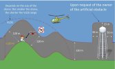
Here's the the EASA discussion of operating altitude limits. It's essentially the same as that in the UK and US and countries.


"MAXIMUM HEIGHT
The remote pilot must ensure that he or she keeps the unmanned aircraft (UA) at a distance less than120 m (400 ft) from the terrain, and the picture below shows how the maximum height that the UAS may reach changes according to the topography of the terrain."

Screenshot 2024-07-21 173104.jpg
 
I think we all know the law is 400ft AGL for sure....
Here's the the EASA discussion of operating altitude limits. It's essentially the same as that in the UK and US and countries.
Very good. I'm glad you agree with me the law is 400ft AGL for sure for all drones. In the US, UK, and EU.

On another topic: Don't know for sure because there is some confusion and discussion (not for me to get involved in) and there are exceptions and I don't live in the EU/UK so I wouldn't know for sure.
 
Further to this discussion, I would ask this question:

What is the tolerance or deviation on the AGL we are speaking

I am living in an area where the terrain is not flat, and there are several hills and cliffs in close proximity everywhere around. It is not always possible to make an estimate of the height of the hills plus the trees above it, so I always make my flights with a large tolerance to passover those variations of height on my flight paths, so that I and my drone always stay in the safe side. This choice however, ends with photos or videos which are not clear enough because of the distance between the drone and the objects or POIs.

To estimate and calculate the heights that I have to climb and/or fly down for the hills while planning my waypoint mission, I am using the altitude data that Google Earth shows. I learned on other threads that there is always a slight deviation (someone said it is about ~12 to ~16 ft) on the long/lang points. Is this also valid for altitude values?

My question is about the deviation or the tolerance for the altitudes given by Google Earth, so that I can be cautious to what extend in my own calculations. How much can I trust the altitude data that Google reports?

Thanks in advance for any clear and detailed input on this point.
In my opinion, the Google Earth elevation data is too coarse to rely on for planning waypoint flights with sensitive altitude levels. And there is no consideration of trees, radio towers, power lines, buildings, and such. If you're trying to set minimum altitudes for the flight, I suggest visually checking the route or manual flights to observe acceptable altitudes.
 
  • Like
Reactions: Eko and anotherlab

DJI Drone Deals

New Threads

Forum statistics

Threads
134,656
Messages
1,597,241
Members
163,142
Latest member
VelosiFed
Want to Remove this Ad? Simply login or create a free account