DJI Mavic, Air and Mini Drones
Friendly, Helpful & Knowledgeable Community
Join Us Now

OpenAthena™ for iOS v2.5 release: Instant geolocation from any drone image

Theta

Member
Approved Vendor
Joined
Feb 25, 2023
Messages
23
Reactions
19
Age
25
Location
Atlanta
Site
theta.limited
Hi y'all,

We just released update v2.5 of our OpenAthena app for iPhones and iPads. This update simplifies and expedites drone use for critical tasks such as Search and Rescue, precision agriculture, law enforcement, and land management.

Unlike other methods that require many photos and lots of time, OpenAthena calculates location instantly from a single image, letting you focus more on your mission.

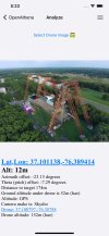
Simply load your image from any compatible drone and tap anywhere within the image. The software then instantly calculates your selected point's exact ground location using OpenAthena's custom terrain-raycast geodesy engine.
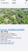
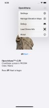
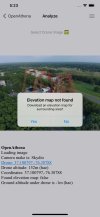
Simulator_Screenshot-iPhone_8_Plus-2024-03-18_at_11.00.18.jpgSimulator_Screenshot-iPhone_Xs_Max-2024-03-18_at_17.20.43.jpg
Simulator_Screenshot-iPhone_Xs_Max-2024-03-18_at_17.23.58.jpgSimulator_Screenshot-iPhone_Xs_Max-2024-03-18_at_17.24.30.jpg

What's new in 2.5:

* Simplified the user interface so image loading and target selection occur on the same screen

* Added switch for imperial vs metric units for distance values

* Shortened the Unique ID label for ATAK Cursor on Target messages

* Fixes for UI dark mode

* Activity indicator which shows while an elevation map is downloading for your drone image

OpenAthena on the App Store:
OpenAthena

We're excited to hear about what you can do with it!

If you have any questions or feedback, please post here or contact us at:
[email protected]

Some DJI drones do not store enough metadata in their images for our software to operate on them. These are known incompatible drone models:
 
  • Like
Reactions: landscapetog
I just downloaded this on my mac, which I guess can run iOS apps too!

If I add drone pictures to my mac photo library, it works perfectly.

This is such an awesome and amazing program!

Thank you for writing it :)
 
OK, an update.

This works with drone JPEGs I add to my Mac photos library but not the source DNG images. Can you modify it to work with DNG files (all my source images are DNGs)? The DNGs also have the same metadata available.

I imagine the same also applies to DNG files on iOS devices.

Also would be amazing to integrate with the Mac filesystem so I don't have to add images to the photos library where iOS can see them. Perhaps the binary can be recompiled to run natively on Mac? I think the same libraries are available on the Mac. My bet is people doing large scale data analysis on drone images will be using Mac / Windows and not iOS / Android.
 
We'll take another look at DNG photos I believe last time we evaluated them they had the same EXIF metadata but didn't have the XMP metadata for stuff like camera angle, but it's certainly worth another look.

That's great feedback on possible usability improvements.A Mac version with easier file access is certainly possible using the existing codebase and build tools. We're also working on pro tools and licensing this technology to system integrators.

If you're interested in following development of the apps, we use GitHub to track issuea and integrate changes:

-Matthew
The JPEGS I feed to OpenAthena come from DNGs, so I think the camera angle stuff has to be in the DNG somewhere. Those are the Azimuth offset and pitch offset, correct?

Here is a screenshot of OpenAthena running on my Mac with a jpeg I created in Adobe Bridge using the ACR converter:

This program is such a WOW!

Screen Shot 2024-03-29 at 11.02.09 AM.png
 
Yes, this app is free. It's one of our first products; it's free so we can promote the new technology and brand. We'd love to hear your feedback on it
I’ve spent some time exploring OpenAthena and much is fairly intuitive. However, I’m not very deep on technology, so I’m in the dark on “EXIF” and “metadata.” I have seen a question pop up about having “exif,” but there’s no way to answer it or look for an explanation.

While most of the pictures I tried worked perfectly with the software, I did get the message that the metadata could not be found on some shots. I fly Mavic 2 Zooms and this seems to be a random problem, but does random really happen in well written programs?

I assume there was some anomaly on my part that caused the failure. In one series of photographs all lacked the necessary metadata. Does my controller need to have online access to get that data while I’m flying? I’m sure it needs it to download a new map for the area, but does that download need to be performed on site?

When it works, which seems to be most of the time, this app is amazing. Items and areas in a photo can be easily targeted on the ground and located later on foot via latitude and longitude or U.T.M. There are other choices that I’m not familiar with, but would like to be informed on.

The biggest improvement would be a manual that explains the options and terminology in settings and the various fault messages.

For example, I’m ignorant enough to have needed to research “hae,” which I now know means “height above the ellipsoid,” the ellipsoid being, I believe, the average surface of the earth after factoring in all the high and low spots. My question now being, how do I use this knowledge in my flying? It seems to be something dealing with G.P.S. Nonetheless, the altitude D.J.I.4go (and G.P.S.) references is basing on zero altitude as my launch point not the ellipsoid.

I like to know how and why things work and what the various options present. There must be a reason behind offering a choice and not offering a choice.

I might not be dense enough to accept that Tinkerbelle is behind the deus ex machina, but I’d probably come at least closer to satisfaction.

I should’ve added that I’m using a 9th generation iPad OS. 17.3.1 to fly my Mavic 2 and use AthenaOne on.
 
Last edited:
EXIF metadata is basically just hidden tags and values automatically included in images taken by a camera. It doesn't need Internet access to record these tags when an image is taken. Usually it includes stuff like exposure time, camera settings, focal length, etc. For drones, it often includes more information like the make and model of the camera, time the photo was taken, GPS coordinates, etc.

Most social media websites and many messaging platforms remove all EXIF metadata to preserve user privacy. Many users don't know about EXIF and don't want to accidentally expose their location. OpenAthena processes EXIF data offline to protect privacy, but it will not be able to operate on an image if EXIF data has been stripped by another program.

The other error message occasionally encountered is due to altitude values. The newer DJI drones record both their relative altitude (from launch point) as well as their absolute altitude (above mean sea level, as defined by the EGM96 Geoid). Generally only absolute altitude can be used with our software.

The digital elevation model for terrain comes from the SRTM GL1 v3 dataset published by NASA and the NGA. It's a pretty good dataset covering most of the Earth with high resolution and accuracy. If we read a drone altitude value which reports the image was taken from an attitude below terrain, it almost always means that the drone elevation values are bad. This can usually be mitigated by letting the drone sit for a minute to acquire a good GPS lock before takeoff.

The OpenAthena app only needs Internet access to download an elevation model for the area around a drone image. If an elevation model of the area has already been downloaded, the software works perfectly fine without an Internet connection.

We probably do need to make a better user manual that's easy to find a link to from within the app. So far this GitHub page is the manual:

Thanks for this information. I’ve bookmarked the GitHub site. There’s a lot of technical information that I don’t know how to read, but the meat of the site is very understandable.

After using OpenAthena on all the pictures I have on both my iPads, I’ve found that over half, usually in groups that were taken on the same day and venue, do not have the required metadata. What could be causing this? There is nothing these pictures all have in common, such as needing to be downloaded from the Cloud. Some did, some don’t. Is there a setting on my drone that could be causing the metadata not to be saved with the picture?

Thanks for your help on this.
 
Not sure, what exact error message does it give?

If it says something like 'missing EXIF data' then it's probably something with how the photos were copied rather than how they were taken from the drone
 
Not sure, what exact error message does it give?

If it says something like 'missing EXIF data' then it's probably something with how the photos were copied rather than how they were taken from the drone.
There is a “missing efix data” on the photos that OpenAthena can’t utilize. I just can’t figure out why the data gets dropped.

I move my photos from the DJIgo4 on my iPad to the photo folder on my iPad. I’m not taking them from the s.d. card, where I might imagine a more complete copy might be. But, then, some of them have MetaData, some don’t. I would think this process would be a transfer, not a copy.

I’ve sent you several pictures via e-mail, some with MetaData, some without, if that would help. The MetaData photos appear to be huge documents and my meager Hotspot on my phone may be too slow to successfully send them.

I expect there must be something in the settings on my drone that are causing this issue. I haven’t been able to identify a difference, though.
JPEG or DNG format?
 
OK, an update.

This works with drone JPEGs I add to my Mac photos library but not the source DNG images. Can you modify it to work with DNG files (all my source images are DNGs)? The DNGs also have the same metadata available.

I imagine the same also applies to DNG files on iOS devices.

Also would be amazing to integrate with the Mac filesystem so I don't have to add images to the photos library where iOS can see them. Perhaps the binary can be recompiled to run natively on Mac? I think the same libraries are available on the Mac. My bet is people doing large scale data analysis on drone images will be using Mac / Windows and not iOS / Android.
Hi!

Hey, can you send me a few DNG files so I can test against and code against if need be?

Thanks,

Bobby
 
  • Like
Reactions: landscapetog
Hi!

I've run into various iOS photo APIs that do strip meta data. Also, iMessage and texting seem to do so as well.

Bobby
Interesting, Bobby. I’m using an iPad with my controller and Mavic 2 Zooms. It is a ninth generation iPad using iOS 17.3.1.

Does the stripping you’ve observed occur all the time or just haphazardly? I have pictures that have retained the metadata and pictures that haven’t. It does seem to be in blocks, but I haven’t been able to figure out the reason.

Glenn
 
Lycus Tech Mavic Air 3 Case

DJI Drone Deals

New Threads

Forum statistics

Threads
131,145
Messages
1,560,366
Members
160,117
Latest member
Photogeezer