DJI Mavic, Air and Mini Drones
Friendly, Helpful & Knowledgeable Community
Join Us Now

Can you fly around Savannah? Not according to the FAA!

s grenald

Active Member
Joined
May 22, 2021
Messages
36
Reactions
41
Age
61
Location
Savannah, GA
So I just picked up my Air 2S on Monday. In hindsight, I should have registered it with the FAA using the serial number on the box, rather than opening it up (10% restocking fee if I have to return it).

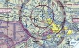
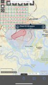
Anyway, being a law-abiding citizen, I applied for two separate authorizations. A D and an E2. If you look at this screenshot, I live right near the border between the two parts of the circle around Hunter Army Airfield. Pink is E2 and Blue is D. There's a small park within walking distance of my house (in E2), and a large open area about a mile away (in D).

Having never done this before, I made the authorizations using the long/lat of my house for one and the open area for the other. Altitude was 100ft. For distance I requested "blanket/wide area" so that I wouldn't have to submit a zillion of these things. I was denied for both. Both denial letters were the same, and here's the text of the reasoning:

  1. Operations at altitudes above the UAS Facility Map (UASFM) are currently not authorized under Section 44809, Exception for Limited Recreational Operations of Unmanned Aircraft.
  2. Blanket or wide area authorizations are not allowed in SVN airspace. Therefore, we cannot approve your request.

    After careful review, we are unable to effectively mitigate the potential risk of your proposed operation within the SVN Class D Surface Area centered on [coordinates] to an acceptable level and, therefore, cannot approve your request at this time.

OK, so #2 is easy. I can resubmit for just a quarter mile around each location. But #1...if I'm reading this right, 100ft was too high. And if I'm reading the map right, the "approved" altitude is ZERO.

So I have a few questions for the expert pilots here: did I read the map right, that the area in the blue & pink circle around Hunter AAF has an allowed altitude of zero feet? If I resubmit essentially the same application with a quarter mile radius around the two locations, could it get rejected out-of-hand because they're basically the same as the previous applications? (i.e., watching some videos on auth requests, the Youtubers all say "I'm not going to read off my application request to you because the FAA doesn't like a lot of copycats." and they might not like "here's an identical application to the one I submitted before, but I changed one small thing, slightly") And could I get rejected because the approved altitude is zero, and therefore it's not possible to get recreational authorization at all?

Do you get the gist of what I'm stumbling for?

Screen Shot 2021-05-27 at 5.40.47 PM.png


Thanks,
Seth
 
So I just picked up my Air 2S on Monday. In hindsight, I should have registered it with the FAA using the serial number on the box, rather than opening it up (10% restocking fee if I have to return it).

Anyway, being a law-abiding citizen, I applied for two separate authorizations. A D and an E2. If you look at this screenshot, I live right near the border between the two parts of the circle around Hunter Army Airfield. Pink is E2 and Blue is D. There's a small park within walking distance of my house (in E2), and a large open area about a mile away (in D).

Having never done this before, I made the authorizations using the long/lat of my house for one and the open area for the other. Altitude was 100ft. For distance I requested "blanket/wide area" so that I wouldn't have to submit a zillion of these things. I was denied for both. Both denial letters were the same, and here's the text of the reasoning:

  1. Operations at altitudes above the UAS Facility Map (UASFM) are currently not authorized under Section 44809, Exception for Limited Recreational Operations of Unmanned Aircraft.
  2. Blanket or wide area authorizations are not allowed in SVN airspace. Therefore, we cannot approve your request.

    After careful review, we are unable to effectively mitigate the potential risk of your proposed operation within the SVN Class D Surface Area centered on [coordinates] to an acceptable level and, therefore, cannot approve your request at this time.

OK, so #2 is easy. I can resubmit for just a quarter mile around each location. But #1...if I'm reading this right, 100ft was too high. And if I'm reading the map right, the "approved" altitude is ZERO.

So I have a few questions for the expert pilots here: did I read the map right, that the area in the blue & pink circle around Hunter AAF has an allowed altitude of zero feet? If I resubmit essentially the same application with a quarter mile radius around the two locations, could it get rejected out-of-hand because they're basically the same as the previous applications? (i.e., watching some videos on auth requests, the Youtubers all say "I'm not going to read off my application request to you because the FAA doesn't like a lot of copycats." and they might not like "here's an identical application to the one I submitted before, but I changed one small thing, slightly") And could I get rejected because the approved altitude is zero, and therefore it's not possible to get recreational authorization at all?

Do you get the gist of what I'm stumbling for?


View attachment 129752


Thanks,
Seth
What serial number? And why does the FAA need it, you should be registering you and not a aircraft. Are you sure your on the correct website and registering with FAA and not a third party rip off site?
 
What serial number? And why does the FAA need it, you should be registering you and not a aircraft. Are you sure your on the correct website and registering with FAA and not a third party rip off site?
The FAA recently changed the recreational registration process to also demand a specific drone's serial number. This change was made to accommodate the upcoming enforcement of Remote ID rules.
 
The FAA recently changed the recreational registration process to also demand a specific drone's serial number. This change was made to accommodate the upcoming enforcement of Remote ID rules.
I understand that, but it isn't in effect is it? I mean I thought I understood "we" don't need to comply for a couple of years? I skipped over to the FAA site earlier this week and didn't see a serial number question to register as we used to have to do..is there a separate section?
 
I understand that, but it isn't in effect is it? I mean I thought I understood "we" don't need to comply for a couple of years?

The Remote ID rule itself isn't in effect but the FAA already changed their registration site to start collecting that serial number data for new or renewed registrations. If your recreational registration hasn't expired yet, you don't have to worry about it yet.
 
The Remote ID rule itself isn't in effect but the FAA already changed their registration site to start collecting that serial number data for new or renewed registrations. If your recreational registration hasn't expired yet, you don't have to worry about it yet.
I'm 107 anyway, they have my serials :p BTW are you from GA?
 
I am still trying to find E2 airspace around SAV. I see on B4UFLY app where it indicates E2, but looking at the sectional charts, I don't see any E2 airspace.
1622159073446.png
 
I am still trying to find E2 airspace around SAV. I see on B4UFLY app where it indicates E2, but looking at the sectional charts, I don't see any E2 airspace.

I was going by B4UFLY as well as Airmaps.com and faa.maps.arcgis.com. My half-assed outline might not be correct because of the overlap from the main Savannah airport, but at the very least, the right side of the segment should be showing up as E2.

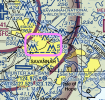
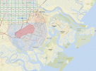
I went into the Sectional Chart and after looking and re-looking (since this is my first look at these things and I don't necessarily know wtf I'm looking at) I saw the arc of the purple dashed line that indicates Class E airspace. You can see it more clearly in my second picture inside the pink rectangle.

delete me pic.jpg

Screen Shot 2021-05-27 at 9.55.27 PM.png
 
Last edited:
The Remote ID rule itself isn't in effect but the FAA already changed their registration site to start collecting that serial number data for new or renewed registrations. If your recreational registration hasn't expired yet, you don't have to worry about it yet.
Yeah, you can't get very far into the FAA Drone Zone website without having a UAV registered. I put stickers with my name, phone # & drone ID on my drone...and then bought a wetsuit, so I'll have to make more of them (this will be the least problematic part of getting set up). I haven't even powered up the drone or tried to register it with DJI yet. Once I get this authorization stuff squared away, I'll log in, do the firmware updates and get the DJI Care insurance.
 
  • Like
Reactions: dawgpilot
So I just picked up my Air 2S on Monday. In hindsight, I should have registered it with the FAA using the serial number on the box, rather than opening it up (10% restocking fee if I have to return it).

Anyway, being a law-abiding citizen, I applied for two separate authorizations. A D and an E2. If you look at this screenshot, I live right near the border between the two parts of the circle around Hunter Army Airfield. Pink is E2 and Blue is D. There's a small park within walking distance of my house (in E2), and a large open area about a mile away (in D).

Having never done this before, I made the authorizations using the long/lat of my house for one and the open area for the other. Altitude was 100ft. For distance I requested "blanket/wide area" so that I wouldn't have to submit a zillion of these things. I was denied for both. Both denial letters were the same, and here's the text of the reasoning:

  1. Operations at altitudes above the UAS Facility Map (UASFM) are currently not authorized under Section 44809, Exception for Limited Recreational Operations of Unmanned Aircraft.
  2. Blanket or wide area authorizations are not allowed in SVN airspace. Therefore, we cannot approve your request.

    After careful review, we are unable to effectively mitigate the potential risk of your proposed operation within the SVN Class D Surface Area centered on [coordinates] to an acceptable level and, therefore, cannot approve your request at this time.

OK, so #2 is easy. I can resubmit for just a quarter mile around each location. But #1...if I'm reading this right, 100ft was too high. And if I'm reading the map right, the "approved" altitude is ZERO.

So I have a few questions for the expert pilots here: did I read the map right, that the area in the blue & pink circle around Hunter AAF has an allowed altitude of zero feet? If I resubmit essentially the same application with a quarter mile radius around the two locations, could it get rejected out-of-hand because they're basically the same as the previous applications? (i.e., watching some videos on auth requests, the Youtubers all say "I'm not going to read off my application request to you because the FAA doesn't like a lot of copycats." and they might not like "here's an identical application to the one I submitted before, but I changed one small thing, slightly") And could I get rejected because the approved altitude is zero, and therefore it's not possible to get recreational authorization at all?

Do you get the gist of what I'm stumbling for?


View attachment 129752


Thanks,
Seth
As a recreational pilot you cannot get authorization to fly higher than the altitude indicated on the facilities map. Period. Full stop. Doesn’t matter if you went through drone zone. If it says zero feet you cannot fly there.

Only Part 107 pilots can request altitudes above what is indicated on the facilities map.
 
  • Like
Reactions: MavicAir2Marc
As a recreational pilot you cannot get authorization to fly higher than the altitude indicated on the facilities map. Period. Full stop. Doesn’t matter if you went through drone zone. If it says zero feet you cannot fly there.

Only Part 107 pilots can request altitudes above what is indicated on the facilities map.
So am I reading the maps properly, that the area in my neighborhood has a zero feet ceiling? My plan was go for Part 107 after I had some hands on experience with my drone, but I guess I need to step that up if it would allow me to fly in my local area
 
So am I reading the maps properly, that the area in my neighborhood has a zero feet ceiling? My plan was go for Part 107 after I had some hands on experience with my drone, but I guess I need to step that up if it would allow me to fly in my local area
Where is your neighborhood exactly? I can’t quite follow from what you’ve already posted.
 
Where is your neighborhood exactly? I can’t quite follow from what you’ve already posted.
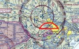
It's in the area highlighted in red on the image above or the area highlighted in pink in the other image. Basically it's a couple of miles North from Hunter Army Airfield. Midtown Savannah, if you're familiar with the area.
 
@BigAl07 or anybody else I’m not 100% confident on this this so hoping someone can verify.

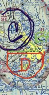
As far as I can see that the green area marked below is an E4 extension of the Class D airspace at SVN due to the dashed blue line. However, you could also interpret it as an E3 extension to the class C airspace of SAV due to the magenta line. Either of these scenarios wouldn’t require an authorization if flying in the green area outlined below.

4D75CAEB-CB41-4DED-B550-8EEC7D36296C.jpeg
However, the facilities map calls this all E2 airspace, though I’m not seeing that on the chart and don’t really see how that would make sense to begin with.
C8B6BE08-BD43-4BF1-955A-0D4A5BC061D9.jpeg

I also don’t understand why the Class D airspace doesn’t have an altitude grid. Even if the class D is not LAANC enabled there should still be altitude boxes.

My advice to the OP was going to be that he doesn’t require authorization to fly as long as he stays out of the Blue and red outlines on the first photo above and can get LAANC authorization to fly in the class C but since the facilities map is saying this whole area is E2 I’d like someone else to confirm for me first.
 
Last edited:
  • Like
Reactions: dawgpilot
Thanks everyone for sharing
 

DJI Drone Deals

New Threads

Members online

Forum statistics

Threads
131,244
Messages
1,561,227
Members
160,195
Latest member
vanillasky