DJI Mavic, Air and Mini Drones
Friendly, Helpful & Knowledgeable Community
Join Us Now

Is it worth even taking drone to Hawaii?

hammerdown

Member
Joined
Dec 4, 2020
Messages
7
Reactions
1
Age
45
Location
Oklahoma
Leaving for Oahu and Kona on 27th pending clears on all the dang COVID testing ive gotta get to go. Wanting to take my new Mavic Air 2 with me. It is registered and I intend to follow all FAA rules and I know them. But, seems there are so many restrictions on Hawaii with no beach flying or state parks.... and the list of state parks is longer than my driving record in high school... lol

Is it worth taking it? Will i be able to fly at all? Hawaii seems to be nothing but beaches and state parks. Can I find decent places to fly that arent restricted? Anyone done any Hawaii flying that has any advice or spots they recommend? Thanks!
 
It would be a loophole seeking approach but what about launching and landing from the intertidal zone or a boat? Is it beach air space that is restricted or the landing launching? That said, I am in no way advocating flights over uninvolved people or breeching airspace etc. etc..
 
They have no jurisdiction once you are in the air, that is all controlled by the FAA. They can only tell you that you are not allowed to takeoff or land on their property, be it public or private land. The same applies to parks, including national parks.

There is no way that I would travel to Hawaii without my drone.
 
Leaving for Oahu and Kona on 27th pending clears on all the dang COVID testing ive gotta get to go. Wanting to take my new Mavic Air 2 with me. It is registered and I intend to follow all FAA rules and I know them. But, seems there are so many restrictions on Hawaii with no beach flying or state parks.... and the list of state parks is longer than my driving record in high school... lol

Is it worth taking it? Will i be able to fly at all? Hawaii seems to be nothing but beaches and state parks. Can I find decent places to fly that arent restricted? Anyone done any Hawaii flying that has any advice or spots they recommend? Thanks!
Yes! I do recommend that you take your drone! even though there's restrictions you can still find some great places to fly and get some stills and shot some video footage, just check your Kittyhawk app for the non restricted areas, get some shots of the waves out on the water and some Top down shots of the water edge of the beach, it's a lot of nice shots
 
I looked up the drone laws for Hawaii and there isn't anything hugely out of the ordinary for any area today. It's not like Washington DC which is a total NFZ.

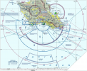
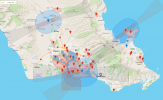
I think there might be a lot of beautiful areas you can fly in Hawaii. Here are snapshots from the DJI Flysafe map, plus the air sectional map for the Honolulu (Oahu?) and that island. You can't fly everywhere, but considering the vast beauty and landscape and topography of Hawaii, if you don't take your drone and come back with some beautiful footage something is terribly wrong.


1608490497748.png

1608490654266.png
 
awesome. thanks fellas. I will take it. Plan on some whale watching too. Not sure of what kind of boat we are taking for that... but if I think i can launch from it.... im taking it whale watching. Thatd be some cool videos.
 
I looked up the drone laws for Hawaii and there isn't anything hugely out of the ordinary for any area today. It's not like Washington DC which is a total NFZ.

I think there might be a lot of beautiful areas you can fly in Hawaii. Here are snapshots from the DJI Flysafe map, plus the air sectional map for the Honolulu (Oahu?) and that island. You can't fly everywhere, but considering the vast beauty and landscape and topography of Hawaii, if you don't take your drone and come back with some beautiful footage something is terribly wrong.


View attachment 119759

View attachment 119760
thank you for posting that! Ive been looking for a map like that... couldnt find one.
 
awesome. thanks fellas. I will take it. Plan on some whale watching too. Not sure of what kind of boat we are taking for that... but if I think i can launch from it.... im taking it whale watching. Thatd be some cool videos.
Be aware of your homepoint. You’ll likely need to update it, unless you takeoff towards the end of the whale watching tour.
 
thank you for posting that! Ive been looking for a map like that... couldnt find one.

You're welcome. The DJI maps are located at DJI Flysafe maps

I would also strongly suggest you download the apps- Airmap and Kittykawk. Both of these apps can get you LAANC ATC authorization, pretty much immediately if you can't do it in advance. There are a few other programs that can do it as well. B4UFly comes to mind.

And as you're going to an island that will have variable winds, I also suggest you download UAV Forecast and possibly the Windy app. You're going to want to know the wind conditions to keep your drone out of trouble.
 
  • Like
Reactions: Mavikhan
Leaving for Oahu and Kona on 27th pending clears on all the dang COVID testing ive gotta get to go. Wanting to take my new Mavic Air 2 with me. It is registered and I intend to follow all FAA rules and I know them. But, seems there are so many restrictions on Hawaii with no beach flying or state parks.... and the list of state parks is longer than my driving record in high school... lol

Is it worth taking it? Will i be able to fly at all? Hawaii seems to be nothing but beaches and state parks. Can I find decent places to fly that arent restricted? Anyone done any Hawaii flying that has any advice or spots they recommend? Thanks!
Think about the logic....... your 8oz plastic drone may do Serious damage to a volcano or the cooled down lava flow ??‍♂️???‍♂️
STUPIDITY ON STEROIDS............
 
You're welcome. The DJI maps are located at DJI Flysafe maps

I would also strongly suggest you download the apps- Airmap and Kittykawk. Both of these apps can get you LAANC ATC authorization, pretty much immediately if you can't do it in advance. There are a few other programs that can do it as well. B4UFly comes to mind.

And as you're going to an island that will have variable winds, I also suggest you download UAV Forecast and possibly the Windy app. You're going to want to know the wind conditions to keep your drone out of trouble.
Do you use an online service to access sectional charts or do you use the ones you can download for free from the FAA?
 
  • Like
Reactions: hammerdown
Do you use an online service to access sectional charts or do you use the ones you can download for free from the FAA?
If I want sectional maps I usually use my computer and get it from Skyvector. Here's the link that I use locally for Chicago's O'Hare Airport Skyvector- Chicago region
After getting to that page I click on VFR chart and you get the sectional map. You can dial up a map for any airport and region. I'll often use both Airmap and the sectional to get an idea of an area I'm not familiar with. Sometimes I'll use Kittyhawk instead of Airmap.
 
awesome. thanks fellas. I will take it. Plan on some whale watching too. Not sure of what kind of boat we are taking for that... but if I think i can launch from it.... im taking it whale watching. Thatd be some cool videos.
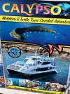
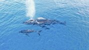
I have had some fantastic experiences with my Mavic in Hawaii. I was able to fly off of a charter boat at Molokini Crater last year. I gave the guide my pics and came back a year later to see them on his advertisement. ( I thought it was cool ) On the big island this year I was able to grab this pic using the zoom function. Yes take your drone!!!

IMG_1984.jpegDJI_0576.jpeg
 
Last edited:
Determining FAA shows you're allowed to use the airspace is all well and good, but state and local laws can dictate where you can take off, land, and operate the drone. By operate, that means where you are standing with the RC while flying.

B4UFly is fine for research but you can't submit a LAANC authorization request from it. You instead need Airmap or Kittyhawk.

I'm surprised flying drones would be prohibited in beaches. Back in 2016 I obtained a package of training videos for the Phantom 3/Inspire 1 where it was flown off of what seemed like a beach area, or at least a park or the like by the shore. Some footage was over a waterfall.

But that was back around 2016 so things might have tightened up since then.
 
  • Like
Reactions: Mavikhan
Leaving for Oahu and Kona on 27th pending clears on all the dang COVID testing ive gotta get to go. Wanting to take my new Mavic Air 2 with me. It is registered and I intend to follow all FAA rules and I know them. But, seems there are so many restrictions on Hawaii with no beach flying or state parks.... and the list of state parks is longer than my driving record in high school... lol

Is it worth taking it? Will i be able to fly at all? Hawaii seems to be nothing but beaches and state parks. Can I find decent places to fly that arent restricted? Anyone done any Hawaii flying that has any advice or spots they recommend? Thanks!
Just remember my number 1 Rule! Never let them see you take off! Works for me!
 
I'm going to Maui in March, and I plan to get a mini 2 to take along. I have a MA2, but I want something smaller (and cheaper, if lost at sea). I will be on a whale watch boat (70 ft catamaran) some days, and I plan to practice hand catching for that activity. I've seen some maui whale drone videos and they are stunning. Any tips on hand catching the mini 2? I saw one tip, to turn it upside down, which they say will turn it off (rather that trying to shut it off by the controller while it's trying to escape from your grip...).
 
  • Like
Reactions: JackL
Lycus Tech Mavic Air 3 Case

DJI Drone Deals

New Threads

Forum statistics

Threads
131,148
Messages
1,560,370
Members
160,117
Latest member
Photogeezer