DJI Mavic, Air and Mini Drones
Friendly, Helpful & Knowledgeable Community
Join Us Now

MAVIC FLY AWAY AND DJI CASE ANALYSES

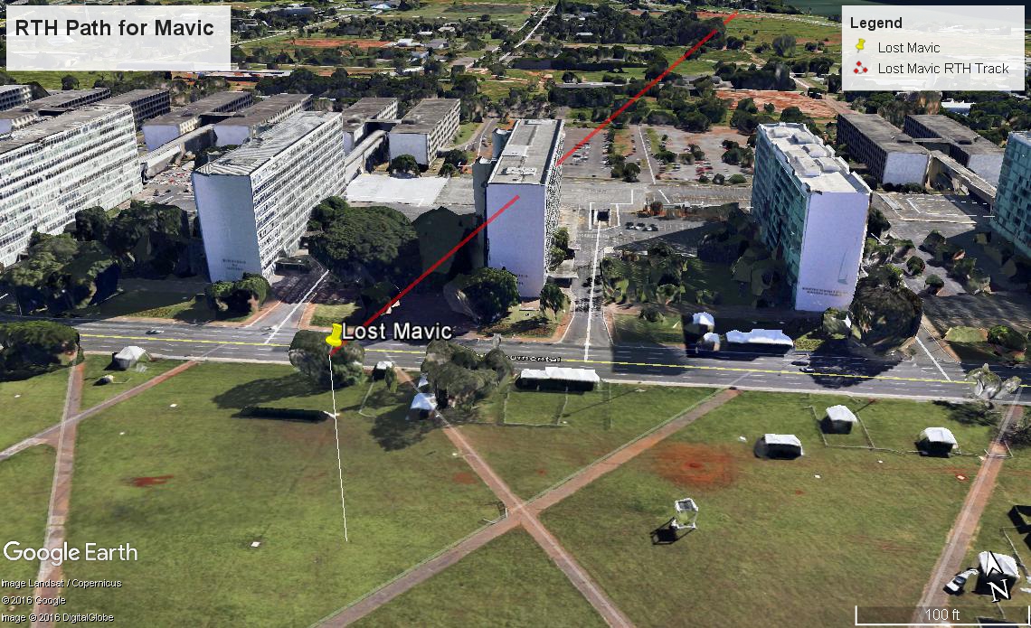
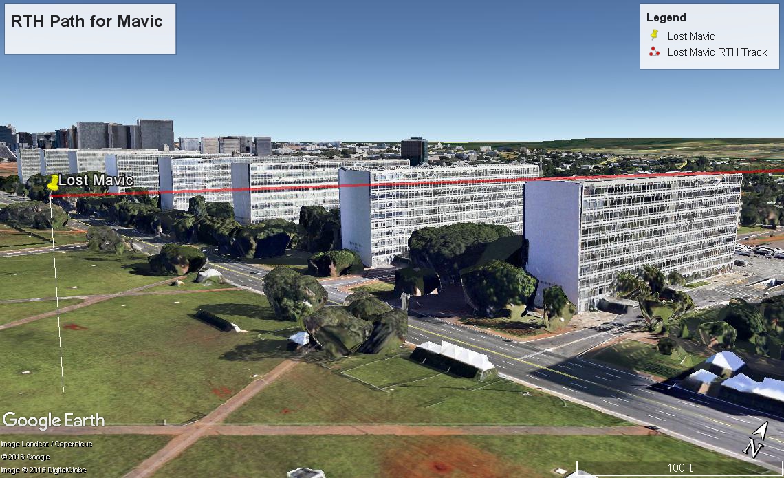
They also build them to go long distance.

No they build a radio system that "can reach" up to 4.3 miles so that it is less likely to lose signal within VLOS. My car can go up to 160mph but don't think it is wise to go that fast and they probably wouldn't honor the warranty if it was proven that I did before I crashed .

The point is , that one line in the manual that says always fly within VLOS makes most of these "Flyaway" claims null and void , if they really wanted to be dicks .
 
  • Like
Reactions: willhay555
No they build a radio system that "can reach" up to 4.3 miles so that it is less likely to lose signal within VLOS. My car can go up to 160mph but don't think it is wise to go that fast and they probably wouldn't honor the warranty if it was proven that I did before I crashed .

The point is , that one line in the manual that says always fly within VLOS makes most of these "Flyaway" claims null and void , if they really wanted to be dicks .
You think people that buy lambos go the speed limit all the time. If DJI was so concerned with line of sight flying they would make all their drones wifi..
 
  • Like
Reactions: wayy510 and AEY
Here is a graphic that shows your Mavic and two different paths back to your location. The first picture shows the Line Of Site path between you and your Mavic. As you can see, it was blocked by the building. This is likely why you lost connectivity to your Mavic. I should also point out that you were facing a highway that was on a berm roughly 20 feet above your location- this was also blocking LOS to your Mavic to some degree.

Lost_Mavic_RTH_Track.jpg


In this second picture, the actual RTH path at 103 meters is shown. As you can see, it would have barely skimmed over the top of the building, if Google Earth is accurate. It may have hit antennas or other objects on top of the building, or it may have simply hit the side of the building. It may even be on top of the building, ready to retrieve.

Lost_Mavic_RTH_Track_3.jpg
 
Last edited:
Don't forget that the OA will only allow the Mavic to ascend to the max altitude set in the controller, so if it encountered the building on the way back & then ascended to clear the building but reached the set max altitude it would then just hover until the battery reached critical and then it would just land.
 
Not to mention that Obstacle Avoidance for RTH may not have been enabled.
 
I think @HFMan got it mostly right.

Your Home Point is at 1010m ASL (Above Sea Level) per GE. This is accurate information.
The terrain under the drone at the Esplanade is at 1075m ASL. This is accurate information.
Your RTH setting is 30 m above your Home Point = 1040m ASL.
Your height above Home Point when you lost connection was 103 m per the log.

(Note: Your RTH altitude (1040) is below ground level (1075 ASL) at the point that you lost connection).

So the RTH would occur at 103m above your home position (1010 + 103 = 1113 m ASL).

So the RTH would begin at (1113 - 1075) = 38 m above the ground level at the Esplanade des Ministerios. The drone does not descend to the set RTH height.

I have set the red line below on a RTH course to your home point and set it at 38m above the Esplanade ASL.

You can have very high confidence in the terrain altitudes above sea level. How accurate the buildings are depicted in GE is not something I would bank on, but given the illustration below, it's very plausible that you hit that building

upload_2017-4-16_9-12-54.png

upload_2017-4-16_9-19-19.png
 
Last edited:
  • Like
Reactions: AyeYo
Here is a graphic that shows your Mavic and two different paths back to your location. The first picture shows the Line Of Site path between you and your Mavic. As you can see, it was blocked by the building. This is likely why you lost connectivity to your Mavic. I should also point out that you were facing a highway that was on a berm roughly 20 feet above your location- this was also blocking LOS to your Mavic to some degree.

Lost_Mavic_RTH_Track.jpg


In this second picture, the actual RTH path at 103 meters is shown. As you can see, it would have barely skimmed over the top of the building, if Google Earth is accurate. It may have hit antennas or other objects on top of the building, or it may have simply hit the side of the building. It may even be on top of the building, ready to retrieve.

Lost_Mavic_RTH_Track_3.jpg

Ah! You beat me to it! - but I put the height above the Esplande at 38 m.
 
The US Constitution, namely the 1st Amendment.

But setting aside the US Constitution.... the OP was not flying around the buildings. They just happen to be on the return path.

Setting aside the US Constitution would be because this happened in Brazil.
 
"Right before the incident, the pilot pulled throttle downward to fly aircraft from 182m in altitude to 103m in altitude before it lost connection, which was inappropriate."

What does DJI mean by that?
DJI means you descended until the remote controller signal was lost (since there was a building between you and your Mavic). You can see that at the end of your flight here:

Location1.jpg
 
Alan, I believe your diagram cuts through the building because you drew a line between the the last known point and home point,at 0 feet elevation. If the drone maintained 103 meters elevation the entire way, it _may_ have cleared the building. But I'm guessing it did not.
 
Alan, I believe your diagram cuts through the building because you drew a line between the the last known point and home point,at 0 feet elevation. If the drone maintained 103 meters elevation the entire way, it _may_ have cleared the building. But I'm guessing it did not.

Using your first post on the matter as inspiration I looked at GE for ground truths.
Looked at the log for the last height above Home Point.

So:
Home Point "0": 1010 m ASL
Height at loss of connection: 103 m AHP ("Above Home Point") = 1113 m ASL
Ground at building on south side: 1075 m ASL
Height above ground at building: 1113-1075 = 38 m

Red line in my GE rendering is set at 38m above ground.

The only thing that I don't have confidence in is the actual height of the building in GE.
DJI's reply regarding OA ineffectiveness would apply too. Either because the building is white and/or the brick pattern could cause aliasing resulting in a mis-estimation of range.

And even if we take your rendering which seems to "graze" the roof, that leads to a high probability that it struck something - like the incorrectly rendered rooftop mechanical rooms or ventilation equipment, etc.

upload_2017-4-16_11-24-23.png
 
And even if we take your rendering which seems to "graze" the roof, that leads to a high probability that it struck something.
The fact that the OP waited 10 minutes and the Mavic never reconnected is the strongest indication that the Mavic did not clear that building.
 
  • Like
Reactions: AlanTheBeast
The fact that the OP waited 10 minutes and the Mavic never reconnected is the strongest indication that the Mavic did not clear that building.

Sure - but the geometrics also help to confirm that. I'm betting
  • It struck the side of the building fell to the ground and someone has it (or it's still there).
    • May even have ended up in a tree south side of the building.
  • It struck a mechanical room or ventilation duct on the roof and someone has it (or it's still there).
So the OP should maybe visit the site and ask the building manager if anything has been found and could he visit the roof and check out the grounds.

And ask for the exact height of the building above the ground.
 
In my graphic, I simply placed the Mavic point at 1113 meters absolute (actually, the entire track is at 1113 meters), don't care about its altitude above ground at that point. Sea Level is Sea Level no matter where you are. It looks like your line has the Mavic at 1113 meters, and the Home point at 1010 meters.
 
Last edited:
In my graphic, I simply placed the Mavic point at 1113 meters absolute, don't care about its altitude above ground at that point. Sea Level is Sea Level no matter where you are.

By that logic we should arrive at the same height above ground since 1113 - 1075 = 38 m. I mean you seem to believe in the 1010 m ASL for the HP, why not for the 1075 m ASL ground altitude at the building?

I did it that way because I would not trust GE over long distances for elevations. But at short ranges and relative differences in height, then you have something.

Further, there is no knowing short of getting the architects plans what the actual height of that building is.

So rendering relative to the local ground is what counts IMO. Believing the top of the building relative to sea level is accurate is really going out there with GE, notwithstanding how accurate it might be for the building rendering itself.

You also have to look at the mechanical rooms on top of the building. They are not correctly rendered. See my earlier graphic. So if "your" grazing height is correct, it would likely hit the mech rooms on the roof.
 
Last edited:
May even have ended up in a tree south side of the building
Since the signal did not reconnect, it's very unlikely that it cleared the building and made it to those trees.
 
I'm just wondering why if we used the same plot points, your path line cuts through the building. Same data, different results? It still looks to me like your line angles down to ground level at the home position.
 
I'm just wondering why if we used the same plot points, your path line cuts through the building. Same data, different results? It still looks to me like your line angles down to ground level at the home position.

You're putting too much confidence in the accuracy of the Sea Level elevations not to mention the building rendering. Relative heights? Sure.

The red line is "above ground", so as the ground level falls from 1075 to 1010 m ASL, the red line will follow that at 38 m above ground.
 
  • Like
Reactions: Bunny Too

DJI Drone Deals

New Threads

Forum statistics

Threads
131,244
Messages
1,561,228
Members
160,195
Latest member
vanillasky