

Sarcasm would be more effective against someone who had not already pled ignorance on the subject. But kudos on your knowledge.Most light aircraft don't have the ability to tell AGL height because a radar altimeter is expensive and not particularly necessary.
They use a barometric sensor just like your drone does.
But if you want to get a nice economical radar altimeter for your drone, here's a good deal on a secondhand unit.
With the antenna, it weighs 3 pounds and you will need to find a 28 volt power supply to run it.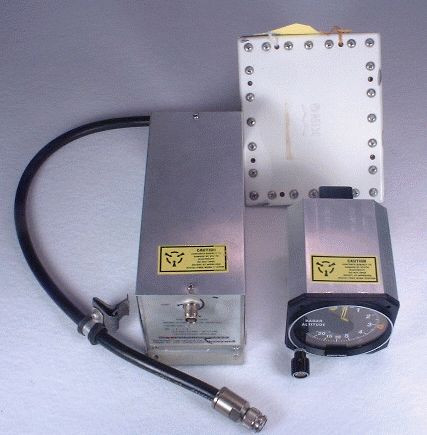
KRA-10 Radar Altimeter System
We are used avionics specialists for General Aviation.www.bennettavionics.com

You are using an out of date browser. It may not display this or other websites correctly.
You should upgrade or use an alternative browser.
You should upgrade or use an alternative browser.
Max altitude
- Thread starter Rocket 3 GT
- Start date
- Joined
- Oct 12, 2016
- Messages
- 28,327
- Reactions
- 31,187
- Location
- Harrisburg, PA (US)
- Site
- mavichelp.com
I dont even know what DEM is
What is a digital elevation model (DEM)? | U.S. Geological Survey
A Digital Elevation Model (DEM) is a representation of the bare ground (bare earth) topographic surface of the Earth excluding trees, buildings, and any other surface objects. DEMs are created from a variety of sources. USGS DEMs used to be derived primarily from topographic maps. Those are...
That's because they have a Radar Altimeter. They are expensive, large, heavy and not "Consumer Drone" compatible.Almost any airplane on the planet can tell the AGL, it would seem not terribly difficult to incorporate that into drones. But I do admit I am not very knowledgeable on this. I am so ignorant I dont even know what DEM is, lol.
Granted there are some "UAV Radar Altimeters' available but they are still expensive (least one we've looked at was $699) and the few I've looked at still won't work because their MAX range of 50M in ideal conditions.
As I already stated I plead ignorance. But somehow I think a smaller one could be managed. The old computers used to take up warehouses, now a micro SD card can hold the equivalent data. But I guess that might be why drones don’t have that capability.
In time the tech will catch up. It's come a LONG way in just the last couple of years. I'd guess in the next 10 years we'll see Radar Altimeters that size of a matchbook and weighing under 25grams. The price, that may not come into play with what we are willing to dish out for our consumer drones.
LuxOcculta
New Member
Maybe I'm not understanding english too good - If i fly off a cliff I start where I'm standing so say 2m - or basically eye level - as I fly off the cliff the drone is now 1000m up as the ground has dropped away. If I fly to the bottom of the cliff will I be able to fly back up again?
Different situation where I am at the base of a hill and want to fly up the slope to the top, say 1000m. the high above ground is only say 50m, but the height from the starting point would be much higher as you are progressing upwards.
Sorry if this sounds stupid, but i fly in a very flat area, but will be going to quite a hilly area shortly.
solidhouse
Well-Known Member
My Mavic 3T will not fly to 4,920 feet where I live. It’s within 50km of a major airport. You must use yours outside of the 500m altitude zone.I love my Mavic 3 enterprise. It flies to an Altitude of 4,920 feet no matter where I am. It's a nice feature if I want to use it.
- Joined
- Oct 12, 2016
- Messages
- 28,327
- Reactions
- 31,187
- Location
- Harrisburg, PA (US)
- Site
- mavichelp.com
The drone tracks the current altitude like this:If i fly off a cliff I start where I'm standing so say 2m - or basically eye level - as I fly off the cliff the drone is now 1000m up as the ground has dropped away. If I fly to the bottom of the cliff will I be able to fly back up again?

After you fly above the takeoff point and reach the maximum allowed altitude, you will no longer be able to ascend. There is no limit to how low you can fly beneath the takeoff point.
Your drone is a flying machine.Maybe I'm not understanding english too good - If i fly off a cliff I start where I'm standing so say 2m - or basically eye level - as I fly off the cliff the drone is now 1000m up as the ground has dropped away. If I fly to the bottom of the cliff will I be able to fly back up again?
It would fly back up again, just like a bird or a helicopter could.
I think the caveat is the poster was asking about an altitude restriction which birds and helicopters don't have. If the poster flew his altitude-restricted drone to the bottom of that mountain and he "landed" then he would be unable to take off them there and fly it back to the top of the mountain. Maybe I'm not following the conversation closely but that's what I thought he was saying.Your drone is a flying machine.
It would fly back up again, just like a bird or a helicopter could.
A hardcoded max altitude of 120m above take off point for a mini drone is a bad, bad idea.
Where did you get the idea that his drone is "altitude restricted"?I think the caveat is the poster was asking about an altitude restriction which birds and helicopters don't have. If the poster flew his altitude-restricted drone to the bottom of that mountain and he "landed" then he would be unable to take off them there and fly it back to the top of the mountain.
You don't have a hard wired max altitude or 120 metres above launch spot.A hardcoded max altitude of 120m above take off point for a mini drone is a bad, bad idea.
The person you are referring to doesn't either, so what does that have to do with the discussion?
Oh ok, I might be in the wrong thread. I thought this was the discussion about the 120m/500m restriction.Where did you get the idea that his drone is "altitude restricted"?
You don't have a hard wired max altitude or 120 metres above launch spot.
The person you are referring to doesn't either, so what does that have to do with the discussion?
")
mobilehomer
Well-Known Member
Only in the EU starting in 2024.Oh ok, I might be in the wrong thread. I thought this was the discussion about the 120m restriction.
If that truly was in Virginia, not the best thing to do for a few reasons.I flew the Dji Mini 4 Pro to 10,000 Feet above ground! Watch the video here!
The first reason would be that the FAA would have a few things to talk with you about.
The other reasons will show up here later.
The poster says:If that truly was in Virginia, not the best thing to do for a few reasons.
The first reason would be that the FAA would have a few things to talk with you about.
The other reasons will show up here later.
"You can do this yourself by getting FAA Authorization then submitting an unlock request at Dji."
https://fly-safe.dji.com/unlock send an unlock request for your area. You will need to get FAA authorization.
Is he lying?
Go to the closest general aviation airport and ask someone to show you the instrument panel on the hottest prop-driven airplane there. You'll almost certainly see a barometric altimeter, the same technology used in our drones, with no means to measure AGL altitude. Anything more sophisticated, like a radar altimeter, is simply too expensive, too heavy, and too complex for the application.My thought is that DjI with todays technology could make monitoring the AGL a thing. Maybe in a future model.
If DJI had a ground-sensing altimeter that fits in one of their drone models, they'd be selling them like hotcakes for commercial aviation and military use.
Last edited:
I did watch the video in post number 35 and did not see or read that information.The poster says:
"You can do this yourself by getting FAA Authorization then submitting an unlock request at Dji."
https://fly-safe.dji.com/unlock send an unlock request for your area. You will need to get FAA authorization.
Is he lying?
Did I miss something?
mobilehomer
Well-Known Member
You need to watch it via the YouTube link. It's there.I did watch the video in post number 35 and did not see or read that information.
Did I miss something?
Your youtube post includes this note.I flew the Dji Mini 4 Pro to 10,000 Feet above ground! Watch the video here!
"Flew the new Dji Mini 4 Pro to 10,000 Feet! I was terrified while doing this! You can do this yourself by getting FAA Authorization then submitting an unlock request at Dji."
Did you actually receive an FAA airspace authorization for that flight?
Similar threads
- Replies
- 9
- Views
- 989


DJI Drone Deals
1. Mini 2
2. Mini 3 Pro
3. Mini 4 Pro
4. Air 2s
5. Air 3
6. Avata 2
7. Mavic 3 Pro
8. Mavic 3 Classic
2. Mini 3 Pro
3. Mini 4 Pro
4. Air 2s
5. Air 3
6. Avata 2
7. Mavic 3 Pro
8. Mavic 3 Classic
New Threads
-
What am I doing wrong? Unlock after LAANC approval.
- Started by twickers14
- Replies: 0
-
-
-

Forum statistics
