


Hi!
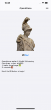
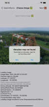
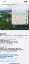
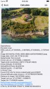
We're excited to announce the launch of OpenAthena™ for iOS v2.0.
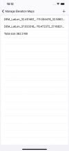
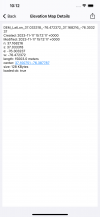
The app allows you to
1. Load any image taken by your drone
2. Automatically download an elevation map
3. Tap anywhere in the image
4. Instantly obtain its precise ground location!

 theta.limited
We're excited to announce the launch of OpenAthena™ for iOS v2.0.
The app allows you to
1. Load any image taken by your drone
2. Automatically download an elevation map
3. Tap anywhere in the image
4. Instantly obtain its precise ground location!
Theta Informatics LLC
Theta provides free and open source UAS geodesy tools which enable a competitive advantage for their users
Attachments
-
 oa-2.0-Simulator_Screenshot-iPhone_12_Pro_Max-2023-11-17_at_10.08.44(1).png686.8 KB · Views: 260
 -
 oa-2.0-Simulator_Screenshot-iPhone_12_Pro_Max-2023-11-17_at_10.12.02(1).png2.7 MB · Views: 282
 -
 oa-2.0-Simulator_Screenshot-iPhone_12_Pro_Max-2023-11-17_at_10.12.36(1).png2.8 MB · Views: 263
 -
 oa-2.0-Simulator_Screenshot-iPhone_8_Plus_iOS_14.0-2023-11-17_at_09.40.48(1).png3.3 MB · Views: 159
 -
 oa-2.0-Simulator_Screenshot-iPhone_12_Pro_Max-2023-11-17_at_10.12.44.png212.8 KB · Views: 130
 -
 oa-2.0-Simulator_Screenshot-iPhone_12_Pro_Max-2023-11-17_at_10.12.50(1).png261.5 KB · Views: 127


