DJI Mavic, Air and Mini Drones
Friendly, Helpful & Knowledgeable Community
Join Us Now

1000 m high altitute flight - Buying Advice

benjolino

Member
Joined
Oct 25, 2025
Messages
7
Reactions
0
Age
45
Location
Germany
Hello everyone,
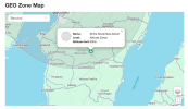
I´m flying drones since 5 years. From the mavic 2 pro to the mini series. In the moment I'm working on a project filming a vulcano in the Philippines. The volcano is active and I have to keep distance but the 500m limit of the Mini 4 Pro is way to low to reach the crater. Now I want to buy a new drone but I'm not sure which one can really fly higher then 500m. We would get a permission form the local authorities but before buying a Mavic 4 Pro for example I need to be sure that it can fly high enough. 1000m would be the absolute minimum. 2000m would be more realistic. Can someone help me decide? Best option budget wise would be the Air3s. I definitely need a tele lens and 1000 + meters from the point of departure. Also the volcano is 45km from the next airport. In the drone map attached it says 500m limit. Mount Canlaon is the place.
Best
Ben
 

Attachments

  • Screenshot 2025-10-27 at 00.19.26.png
    Screenshot 2025-10-27 at 00.19.26.png
    580.8 KB · Views: 20
I believe the Mavic 3/4 models will go up to 1000M if you're more than 30 miles/50KM from an airport. I'm not sure if DJI would allow a waiver in the fly app to go higher

I believe the limit on Autel drones is 800M
 
  • Like
Reactions: GadgetGuy
I believe the Mavic 3/4 models will go up to 1000M if you're more than 30 miles/50KM from an airport. I'm not sure if DJI would allow a waiver in the fly app to go higher

I believe the limit on Autel drones is 800M
Air 3S also is capable of 1000m, when more than 50km from the nearest airport.
However, the location clearly is not, based upon the map.
Needs an altitude hack, only available on older aircraft.
 
  • Like
Reactions: Cafguy
Looks like your about 30km from nearest airport.
What elevation are you operating from?
 
What app is that Geozone map screenshot from? (I'll be heading to the Philippines next spring and would like to look at airspace restrictions...).

Thanks and good luck.
 
So the screenshot I uploaded is from the official DJI site: DJI FlySafe

I´m flying from a location around 1000m above sea level and the crater is around 2000m.
I guess the best option is to find a Mavic 3 that has old enough firmware to be hacked but that's really hard to find here in Germany. Other option could be to get a permit by DJI to fly 1000m in that area. I could try to get a permit from the filipino authorities.
 
A Mavic 3 Pro with software hack from drone-hacks will be a good choice. The DH software will remove the altitude limit, you can fly as high as you wish. It will give you FCC transmission, and it will also remove the log-in requirements.
The Mavic 3 Pro has an excellent 4/3 wide angle camera, and a very good short tele lens (ca 70mm), plus a longer tele lens which is surprisingly good.
 
So the screenshot I uploaded is from the official DJI site: DJI FlySafe

I´m flying from a location around 1000m above sea level and the crater is around 2000m.
I guess the best option is to find a Mavic 3 that has old enough firmware to be hacked but that's really hard to find here in Germany. Other option could be to get a permit by DJI to fly 1000m in that area. I could try to get a permit from the filipino authorities.
Getting a custom unlock from DJI to fly to 1000m should be quite easy. You are 45km away instead of 50km which is just an artificial number DJI came up with. Just be aware that the custom unlock creates a polygon or circle for you to fly within, that also creates an NFZ outside of it. Make sure the polygon or circle is large enough to include anywhere you might want to fly from to reach the volcano as well as the volcano itself.

A permit from Filipino authorities won't help you without a custom unlock from DJI, and is probably unnecessary, unless you find out otherwise.
 
I think for me it makes sense to go for the Air3s. We are traveling on a motorcycle and have limited space. Last time I only brought my Mini4pro and the Air3s uses the same remote. The Mavic is massive unfortunately otherwise I would certainly go for it. But we are two people on a Royal Enfield Bullet 350 and we also bring 2 Sony Cameras and a gimbal and many lenses. Soon we need a car :)
I imagine image quality wise the mavic is far better. But in our last project I mixed the shots from my previous Mini3Pro with the Sony A7S3 footage and in the end it looked good together.
 
Does this work? Would it mean I have to land half way? If yes that would be impossible. If I can reset it midair that would be amazing
I know the location can be reset while flying. I used to do it all the time. I would take off on my yard which had a 100% tree canopy, fly across the street where it was open sky and reset the home point while hovering. I never actually tested it with a RTH as I always flew it back to me.
I don't know if the altitude portion reset. You could always test it in a safe environment.
 
  • Like
Reactions: GadgetGuy
Is this an option? Fly to max altitude, reset the home point at that altitude, then fly up to a “new” max altitude.
Yes, as long as you still have full control while landing, shutting off the motors and rearming them. That resets the altitude to zero again. Just make sure to reset RTH to the location of the controller immediately after.
 
Yes, as long as you still have full control while landing, shutting off the motors and rearming them. That resets the altitude to zero again. Just make sure to reset RTH to the location of the controller immediately after.
How can I shut down the motos while flying? Sounds dangerous
 
Yes, as long as you still have full control while landing, shutting off the motors and rearming them. That resets the altitude to zero again. Just make sure to reset RTH to the location of the controller immediately after.
If this were me: I'd be wary of two things.

1) Dropping down to land a number of times (to reset HP). What are the chances of landing in a dip, or hollow where there will be a physical obstruction between the controller antennae and the drone.

2) The distance to travel and the added time needed to select a landing spot, bring the drone safely down, re-arm the motors and take off again, get to working altitude, get the shots needed, and return. Will there be enough juice left in the battery to get back down to base again?

I had a similar dilemma shooting an Iron Age hill fort on top of a 2,000 foot mountain (Tre r'Ceiri - if you're curious).

The 'easy' way was was to park up at the bottom, send the (D-H hacked) drone up, grab some quick shots and RTH.

The other option was for me to get my arse into gear and climb the west slope to maximize productive flight time.

The benefit to that approach was that I was able to objectively gauge wind conditions at that very exposed location and altitude before I sent my Mavic up. It also meant that the flight was completely legal.

I nearly gave myself a heart attack in the process, but it was worth it.
 
Last edited:
How can I shut down the motos while flying? Sounds dangerous
You have to land in an area where you still have a lear line of sight to the drone, and turn off the motors, and immediately restart to reset the home point. Drone is never powered off, but you still must have full signal connection for the restart of the motors. Plan the spot carefully in advance, perhaps by flying from the spot of your interim landing to your planned final start location. Obviously, it needs to be an elevated flat area midway. It can be done.
 
If this were me: I'd be wary of two things.

1) Dropping down to land a number of times (to reset HP). What are the chances of landing in a dip, or hollow where there will be a physical obstruction between the controller antennae and the drone.

2) The distance to travel and the added time needed to select a landing spot, bring the drone safely down, re-arm the motors and take off again, get to working altitude, get the shots needed, and return. Will there be enough juice left in the battery to get back down to base again?

I had a similar dilemma shooting an Iron Age hill fort on top of a 2,000 foot mountain (Tre r'Ceiri - if you're curious).

The 'easy' way was was to park up at the bottom, send the (D-H hacked) drone up, grab some quick shots and RTH.

The other option was for me to get my arse into gear and climb the west slope to maximize productive flight time.

The benefit to that approach was that I was able to objectively gauge wind conditions at that very exposed location and altitude before I sent my Mavic up. I nearly gave myself a heart attack in the process, but it was worth it.
1) Must be a preselected elevated spot, with clear, unobstructed LOS.
2) With longer flight times in newer aircraft, this is less of an issue
Obviously, an elevation hack, if available, would be preferable.
 
Now someone offered me a mavic 3 pro with old firmware that is old enough to be hacked. What do you think? Is this a good option? I never used the mavic 3. One downside is that I would have to carry 2 remotes since the RC2 from my mini 4 pro is not working with the mavic 3. The price for the drone is 1500€ for the fly more combo.
 

DJI Drone Deals

New Threads

Forum statistics

Threads
139,096
Messages
1,644,395
Members
167,380
Latest member
ebjratliff2850
Want to Remove this Ad? Simply login or create a free account