DJI Mavic, Air and Mini Drones
Friendly, Helpful & Knowledgeable Community
Join Us Now

200 feet Max Altitude Reached?

dsd317

Well-Known Member
Joined
Oct 14, 2016
Messages
736
Reactions
461
I haven't flown in a while so I'm not sure what has changed. In the exact same locations as before, I used to be able to fly over 200 feet altitude with authorizations to fly up to 400 feet. Now, I cannot fly over 200 feet. App keeps telling "Max altitude reached"...or something like that. In my app max altitude is set to 400 feet as well. Any idea what's going on?
 
Are you possibly near an "altitude zone", for example the extended zones coming off runways of a nearby airport?

Check DJI's Geomap which should show these areas:

 
I haven't flown in a while so I'm not sure what has changed. In the exact same locations as before, I used to be able to fly over 200 feet altitude with authorizations to fly up to 400 feet. Now, I cannot fly over 200 feet. App keeps telling "Max altitude reached"...or something like that. In my app max altitude is set to 400 feet as well. Any idea what's going on?
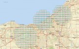
if you can check you limits in your area: They have made a lot of changes ;

Screenshot 01-03-2021 23.56.31.jpg


Phantomrain.org
Gear to fly your Mavic in the Rain and Land on Water.
 
Are you possibly near an "altitude zone", for example the extended zones coming off runways of a nearby airport?

Check DJI's Geomap which should show these areas:

Yes...I think that's it. According to DJI's Geomap, I was in an "altitude zone". Funny thing is that I've flown there in the past (less than a year ago) and was able to fly to 400 feet (many different times). The other thing was that today, I also received LAANC approval to fly up to 400ft.
 
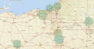
Here is another view you can get : Its interesting that some of the air restrictions go over the water.

Screenshot 01-09-2021 10.32.34.jpg
 
  • Like
Reactions: dsd317
This is a great link for a quick look into what is happening in the air: Just zoom in and the Magic happens.

ArcGIS Web Application

Phantomrain.org
Gear to fly your drone in and out of the Storm.

Your link to the FAA's UAS Facility Map, which is useful for finding out where you can obtain airspace authorization. However DJI sometimes has their own altitude zones that don't exactly correspond with controlled airspace. Even if you are "legal" to fly with the FAA, DJI's "FlySafe" geofencing can prevent (or restrict) you from flying in an area that DJI has decided is a risk to aviation safety, such as certain heights near airport approach/departure paths. As far as I know, its difficult or impossible to get those types of zones unlocked from DJI (outside of certain enterprise-level or public safety users).
 
  • Like
Reactions: dsd317
Your link to the FAA's UAS Facility Map, which is useful for finding out where you can obtain airspace authorization. However DJI sometimes has their own altitude zones that don't exactly correspond with controlled airspace. Even if you are "legal" to fly with the FAA, DJI's "FlySafe" geofencing can prevent (or restrict) you from flying in an area that DJI has decided is a risk to aviation safety, such as certain heights near airport approach/departure paths. As far as I know, its difficult or impossible to get those types of zones unlocked from DJI (outside of certain enterprise-level or public safety users).

Exactly in my case. FAA's map shows my location at 400 feet limit, yet DJI's shows same location at 60 meters (196.85 feet) limit.
 
  • Like
Reactions: dawgpilot
Exactly in my case. FAA's map shows my location at 400 feet limit, yet DJI's shows same location at 60 meters (196.85 feet) limit.
DJI used to fit their zones more closely with the facilities map. It wouldn't be so bad if you could self-unlock an altitude zone.

I suggest contacting them about the discrepancy.
 
I haven't flown in a while so I'm not sure what has changed. In the exact same locations as before, I used to be able to fly over 200 feet altitude with authorizations to fly up to 400 feet. Now, I cannot fly over 200 feet. App keeps telling "Max altitude reached"...or something like that. In my app max altitude is set to 400 feet as well. Any idea what's going on?
If you have LANNC authorization to fly up to 400', two things come to mind. First check the max altitude you have selected. Second, you may have to disable the max altitude permission set by DJI.
 
Lycus Tech Mavic Air 3 Case

DJI Drone Deals

Members online

Forum statistics

Threads
131,088
Messages
1,559,716
Members
160,072
Latest member
gtfuture11