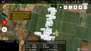
If you just fly manually across the property, does it still show a significant altitude error?Just tried the same mission at 15m indicated on the controller, the error on landing was 8m, so much less than the automatic mode but still well over what I thought the GPS altitude could maintain given it was locating 17 satellites at any one time.
I'm trying to eliminate something about the waypoint flights as that could affect all 5 drones.