DJI Mavic, Air and Mini Drones
Friendly, Helpful & Knowledgeable Community
Join Us Now

A question for those whose maths isn't as rusty as mine.

Yorkshire_Pud

Well-Known Member
Premium Pilot
Joined
Feb 24, 2022
Messages
4,843
Reactions
4,373
Age
63
Location
UK
The logs contain instantaneous values for the drone's pitch, roll, "xspeed" ( North/South ) and "yspeed" ( East/West ).
The speeds are ground speeds but I am wondering if, over the duration of any given flight log, the reported speeds for each reported angle of tilt ( pitch and roll ) were averaged ( sum/ number-of-instances-of-that-angle ) would you end up with a crude but reasonably accurate mapping of angle of tilt to airspeed? I.e over the whole journey would the averaging canel out wind speed? And, if this was done for each flight log of that drone would it improve the accuracy of the mapping.
The arithmetic would be carried out by a computer program, I am not considering doing it by 'hand' lol.
 
This is an interesting idea but I suspect there are too many variables to get an accurate answer. The lack of consistency of the wind would introduce a big error. The wind where I live can change from near zero to 20-30 mph in a very short distance or time. I live in the mountains so mine might be worst case. If you are successful it will interesting to hear the results.

I actually did a slightly more controlled version of this a while ago. I used a leaf blower bungeed to a step ladder and measured the ”wind” speed with a anemometer and took picture of the drone flying from the side with the camera held as level as possible. I then used a protractor on the photo to determine the tilt angle.
 
  • Like
Reactions: Yorkshire_Pud
Any aircraft needs a pitot/static air data system to accurately read airspeed. Tilt and power can (theoretically) give commanded airspeed, but whether or not the aircraft achieves that airspeed will depend on several things.
 
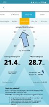
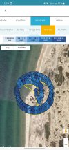
If you're just trying to get an idea of the in-flight wind that you encountered during your flight, air data 360 lite has that option to show from the flight logs.

Can probably take that data and subtract it out but I don't think it's going to show it at every finer instance of the flight to be as useful to you to for a more detailed detailed (plus not sure if you could download the wind map for example as a csv)

Screenshot_20221114_141008_Airdata UAV.jpg

Screenshot_20221114_141017_Airdata UAV.jpg
 
Any aircraft needs a pitot/static air data system to accurately read airspeed.
Manned and winged aircraft perhaps but do helicopters? What multi-rotor drone needs to do that?
DJI equipment allows ground speeds to be seen but I have yet to see any mention of airspeed being displayed, which I personally would find interesting but if added to the routine telemetry displayed along with ground speed in an app it might confuse some people.
Tilt and power can (theoretically) give commanded airspeed, but whether or not the aircraft achieves that airspeed will depend on several things.
The comment about power perhaps opens up some interesting lines of thought. But, within the preprogrammed tilt and motor speed parameters, why would the drone's ability to obtain a given airspeed be questionable?
To my mind it seems that the airspeed, though unknown by us, is the one thing that DJI's progamming more or less guarantees.
 
If you're just trying to get an idea of the in-flight wind that you encountered during your flight, air data 360 lite has that option to show from the flight logs.

Can probably take that data and subtract it out but I don't think it's going to show it at every finer instance of the flight to be as useful to you to for a more detailed detailed (plus not sure if you could download the wind map for example as a csv)
Thanks Karl but wind speed is not my main focus, I am primarily interested in mapping pitch/roll to airspeed and wind complicates the matter lol.
That said your latter is an interesting thought, if they can calculate the wind speed then do they have such a mapping already? From their comments perhaps they do! LOL
 
In steady flight (aircraft speed, direction and altitude constant, and wind speed and direction constant), then airspeed is a single-valued function of tilt and air density (since drag is a function of air density).

So averaging is not going to work unless you exclude data during non-steady flight, ensure that you have a dataset of tilt/ground velocity data where all directions are equally represented, and correct for density.
 
  • Like
Reactions: Yorkshire_Pud
In steady flight (aircraft speed, direction and altitude constant, and wind speed and direction constant), then airspeed is a single-valued function of tilt and air density (since drag is a function of air density).

So averaging is not going to work unless you exclude data during non-steady flight, ensure that you have a dataset of tilt/ground velocity data where all directions are equally represented, and correct for density.
Ahhhhhh, torpedoed, glug, glug, glug, but thanks
 
Lycus Tech Mavic Air 3 Case

DJI Drone Deals

New Threads

Forum statistics

Threads
130,593
Messages
1,554,206
Members
159,598
Latest member
fast54