DJI Mavic, Air and Mini Drones
Friendly, Helpful & Knowledgeable Community
Join Us Now

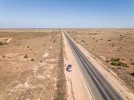
Across the Nullarbor Plain - 91mile straight road without a single bend

Driving that must be a nightmare !
It was actually an amazing experience. There is also a section of Nullarbol Plain several hundred of kilometers long called "treeless". There are no trees there just occassional shrub. An empty space as far as eye can see. Incredible landscape but I admit, probably not for the fait-hearted!!!
 
It was actually an amazing experience. There is also a section of Nullarbol Plain several hundred of kilometers long called "treeless". There are no trees there just occassional shrub. An empty space as far as eye can see. Incredible landscape but I admit, probably not for the fait-hearted!!!
But how do you avoid falling asleep or your attention wandering ?
 
But how do you avoid falling asleep or your attention wandering ?
Lot's of coffee and regular breaks for droning 😀 
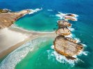
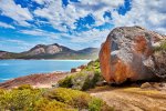
And also desire to visit places like these on the other side....
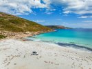
 

Attachments

  • DJI_20240304162401_0060_D-DNG.jpg
    DJI_20240304162401_0060_D-DNG.jpg
    1.1 MB · Views: 33
  • DJI_20240306185634_0012_D-DNG.jpg
    DJI_20240306185634_0012_D-DNG.jpg
    2.7 MB · Views: 32
  • _M2R7965.jpg
    _M2R7965.jpg
    1.9 MB · Views: 32
Last edited:
LOL. Technology in modern cars these days makes driving a lot easier for sure.. But still, one needs to remain focus and alert during such long and monotonous drives. All part of overlanding fun
Yeah, their self-driving databases don’t yet have any real world experience at detecting kangaroos and ostriches crossing the road! LOL!
 
Awesome photos, thanks for sharing!
 
  • Like
Reactions: MS Coast and sarahb
I believe there is even an 18 hole golf course along the length of the Nullarbor Rd. The longest golf course in the world. Pick up a score card at either end in Ceduna or Kalgoorlie. Cost is $70 I think.
 
I believe there is even an 18 hole golf course along the length of the Nullarbor Rd. The longest golf course in the world. Pick up a score card at either end in Ceduna or Kalgoorlie. Cost is $70 I think.
I believe you are right. That would be definitelly one nice way not to fall asleep during the long drive🤣🤣
 
I've seen much shorter 2 lane straight line roads in the US that were some of the deadliest in the country. Monotony and misjudging distance when passing were top reasons. It's good yours has lots of attractions/distractions along the way.
 
We crossed the Nullarbor during our year-long ‘Big Lap’ of Australia towing a 3-tonne caravan. The ever present wind helped the mind concentrate!

More details of the Nullarbor crossing Here

Unfortunately it’s not easy to pull-off with a caravan in tow to the dirt tracks along the way that lead to the enormous sea cliffs, which make for spectacular drone shots. Having road signs in advance of the narrow turn-offs would make it far easier to spot them. Then, of course, there’s no telling if it’s possible to turn around at the end of the track with the caravan.
 
Last edited:
Great photos and familiar places from 20 years ago (before I started playing with drones).
Can you advise what software you use to adjust the DNG file please.
Many thanks
 
Great photos and familiar places from 20 years ago (before I started playing with drones).
Can you advise what software you use to adjust the DNG file please.
Many thanks
My typical workflow for processing DNG files from Mavic 3: I usually start with DxO PureRaw. Then open in Adobe Lightroom for WB and basic grading also applying pre-sharpening. Export as 16bit TIFF. Open in Adobe Photoshop and do the final tweaks. Save as 8bit TIFF. Save also as JPEG in suitable size for online apps if intending to share and/or publish on social media.
 
  • Like
Reactions: B.Sadeh
My typical workflow for processing DNG files from Mavic 3: I usually start with DxO PureRaw. Then open in Adobe Lightroom for WB and basic grading also applying pre-sharpening. Export as 16bit TIFF. Open in Adobe Photoshop and do the final tweaks. Save as 8bit TIFF. Save also as JPEG in suitable size for online apps if intending to share and/or publish on social media.
Many thanks for the detailed response. Highly appreciated.
 
I remember driving the nullabor plain back in the 70s when a lot of it was unsealed. That was a long trip
 
Lycus Tech Mavic Air 3 Case

DJI Drone Deals

New Threads

Forum statistics

Threads
134,210
Messages
1,592,347
Members
162,799
Latest member
Zephaniah2001