


You are using an out of date browser. It may not display this or other websites correctly.
You should upgrade or use an alternative browser.
You should upgrade or use an alternative browser.
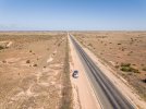
Across the Nullarbor Plain - 91mile straight road without a single bend
- Thread starter Filmarik
- Start date

Yorkshire_Pud
Well-Known Member
It was actually an amazing experience. There is also a section of Nullarbol Plain several hundred of kilometers long called "treeless". There are no trees there just occassional shrub. An empty space as far as eye can see. Incredible landscape but I admit, probably not for the fait-hearted!!!Driving that must be a nightmare !
Yorkshire_Pud
Well-Known Member
But how do you avoid falling asleep or your attention wandering ?It was actually an amazing experience. There is also a section of Nullarbol Plain several hundred of kilometers long called "treeless". There are no trees there just occassional shrub. An empty space as far as eye can see. Incredible landscape but I admit, probably not for the fait-hearted!!!
Lot's of coffee and regular breaks for droningBut how do you avoid falling asleep or your attention wandering ?
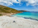
 And also desire to visit places like these on the other side....
Attachments
Last edited:

Autopilot!But how do you avoid falling asleep or your attention wandering ?

LOL. Technology in modern cars these days makes driving a lot easier for sure.. But still, one needs to remain focus and alert during such long and monotonous drives. All part of overlanding funAutopilot!
Yeah, their self-driving databases don’t yet have any real world experience at detecting kangaroos and ostriches crossing the road! LOL!LOL. Technology in modern cars these days makes driving a lot easier for sure.. But still, one needs to remain focus and alert during such long and monotonous drives. All part of overlanding fun
Flying Shroppie
Well-Known Member
Can you imagine the poor soul who had the job of painting the white line in the centre. That must qualify for "The most boring job ever"
Yeah, their self-driving databases don’t yet have any real world experience at detecting kangaroos and ostriches crossing the road!
ThanksAwesome photos, thanks for sharing!
platty
Well-Known Member
I believe there is even an 18 hole golf course along the length of the Nullarbor Rd. The longest golf course in the world. Pick up a score card at either end in Ceduna or Kalgoorlie. Cost is $70 I think.
I believe you are right. That would be definitelly one nice way not to fall asleep during the long driveI believe there is even an 18 hole golf course along the length of the Nullarbor Rd. The longest golf course in the world. Pick up a score card at either end in Ceduna or Kalgoorlie. Cost is $70 I think.

I've seen much shorter 2 lane straight line roads in the US that were some of the deadliest in the country. Monotony and misjudging distance when passing were top reasons. It's good yours has lots of attractions/distractions along the way.
We crossed the Nullarbor during our year-long ‘Big Lap’ of Australia towing a 3-tonne caravan. The ever present wind helped the mind concentrate!
More details of the Nullarbor crossing Here
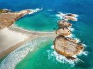
Unfortunately it’s not easy to pull-off with a caravan in tow to the dirt tracks along the way that lead to the enormous sea cliffs, which make for spectacular drone shots. Having road signs in advance of the narrow turn-offs would make it far easier to spot them. Then, of course, there’s no telling if it’s possible to turn around at the end of the track with the caravan.
More details of the Nullarbor crossing Here
Unfortunately it’s not easy to pull-off with a caravan in tow to the dirt tracks along the way that lead to the enormous sea cliffs, which make for spectacular drone shots. Having road signs in advance of the narrow turn-offs would make it far easier to spot them. Then, of course, there’s no telling if it’s possible to turn around at the end of the track with the caravan.
Last edited:
B.Sadeh
Member
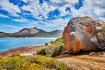
Great photos and familiar places from 20 years ago (before I started playing with drones).
Can you advise what software you use to adjust the DNG file please.
Many thanks
Can you advise what software you use to adjust the DNG file please.
Many thanks
My typical workflow for processing DNG files from Mavic 3: I usually start with DxO PureRaw. Then open in Adobe Lightroom for WB and basic grading also applying pre-sharpening. Export as 16bit TIFF. Open in Adobe Photoshop and do the final tweaks. Save as 8bit TIFF. Save also as JPEG in suitable size for online apps if intending to share and/or publish on social media.Great photos and familiar places from 20 years ago (before I started playing with drones).
Can you advise what software you use to adjust the DNG file please.
Many thanks
B.Sadeh
Member
Many thanks for the detailed response. Highly appreciated.My typical workflow for processing DNG files from Mavic 3: I usually start with DxO PureRaw. Then open in Adobe Lightroom for WB and basic grading also applying pre-sharpening. Export as 16bit TIFF. Open in Adobe Photoshop and do the final tweaks. Save as 8bit TIFF. Save also as JPEG in suitable size for online apps if intending to share and/or publish on social media.
You are welcome.Many thanks for the detailed response. Highly appreciated.
AnzacJack
Australian Defence Veteran
I remember driving the nullabor plain back in the 70s when a lot of it was unsealed. That was a long trip
Similar threads
- Replies
- 6
- Views
- 776
- Replies
- 4
- Views
- 490
- Replies
- 5
- Views
- 1K
- Replies
- 2
- Views
- 821


DJI Drone Deals
New Threads
-
DJI Fly 1.5 keeps crashing on new OS Android 13, if I update will I lose CJD and DH?
- Started by phad
- Replies: 0
-
 4 Pro STILL doubting if the Mavic 4 Pro combo upgrade is worth it?
- Started by christangey
- Replies: 0
-

-
DJI Mini 5 Pro: Which Color Profile Should You Actually Use?
- Started by trisen1981
- Replies: 0
-

Forum statistics
