DJI Mavic, Air and Mini Drones
Friendly, Helpful & Knowledgeable Community
Join Us Now

Airmap - done, gone, outta' here!

SethB

Well-Known Member
Joined
Feb 9, 2021
Messages
685
Reactions
715
Location
Oregon
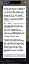
Airmap quietly closed down its LAANC authorizations. Although it's been on again and off again for various reasons, I and others appreciated that it had a very straightforward interface.

On to the next LAANC provider... Aloft. UASidekick. Something. For me, I appreciate having both a desktop and an iOS app - helps in planning and securing clearance the day before or days before.

Here's the full list of providers at FAA (scroll down the page):

1685501761681.png
 

Attachments

  • 1685501736718.png
    1685501736718.png
    11.7 KB · Views: 12
This is too bad, I moved over to Airmap after Air Control kept forcing me to put my long complex PW every time I used it so I won't be going back to that. Are there any other decent alternatives?
 
I've tried practically all of the LAANC apps and did like Airmap the best for their interface. (Not a great company though - did lots of shady things but that's beside the point).

I have found my new favorite (and I might even like it better than Airmap). Give Autopylot a whirl for both Android and iOS. Once you use that, I bet nobody will miss Airmap
 
  • Like
Reactions: jencarta
Airmap quietly closed down its LAANC authorizations. Although it's been on again and off again for various reasons, I and others appreciated that it had a very straightforward interface.

On to the next LAANC provider... Aloft. UASidekick. Something. For me, I appreciate having both a desktop and an iOS app - helps in planning and securing clearance the day before or days before.

Here's the full list of providers at FAA (scroll down the page):

View attachment 164769
I will certainly miss it. Air Control does not send a text confirmation of a manual flight authorization request within 24 hours like AirMap did. For some peculiar reason, an approved authorization that I received for a manual request in a zero grid area in San Diego, does not show up in the Air Control app. According to the message that is the subject of this thread, that 6/17/2023 authorization is still valid and it still shows that in the AirMap app. The AirMap team has not contacted me about the authorization as they stated in the message. My biggest beef with Air Control is the experience I am having with the lack of a confirmation text as an acknowledgment.
 
I've tried practically all of the LAANC apps and did like Airmap the best for their interface. (Not a great company though - did lots of shady things but that's beside the point).

I have found my new favorite (and I might even like it better than Airmap). Give Autopylot a whirl for both Android and iOS. Once you use that, I bet nobody will miss Airmap
I also recommend giving Autopylot a try!
 
I checked Autopylot and its shows that you can fly over National Parks, it doesn't look updated, not sure how much should I trust.
 
I checked Autopylot and its shows that you can fly over National Parks, it doesn't look updated, not sure how much should I trust.
LAANC services only cover the controlled airspace around airports where clearances are available. They don’t substitute for B4UFly and other sources of info.

Autopylot is on the FAA list as approved, that means it’s trustworthy. But only for requesting clearance near airports participating in LAANC.
 
  • Like
Reactions: koco2202
I checked Autopylot and its shows that you can fly over National Parks, it doesn't look updated, not sure how much should I trust.
LAANC services only cover the controlled airspace around airports where clearances are available. They don’t substitute for B4UFly and other sources of info…
I put Autopylot through its paces.

First, an apology to @koco2202. Unexpected: AP does indeed attempt to include the kind of information we go to B4UFly, including various no-fly zones way beyond airports and LAANC, including Wildernesses and National Parks.

It correctly marked the Oregon & Washington National Parks and Wildernesses. It missed the Mt. St. Helens National Volcanic Monument, much of which is a no-fly zone. In fairness, B4UFly also misses this location.

It misses or just pops up a caution about some well-known wildlife refuges on the Oregon Coast. You would have to know your local flying area and/or use B4UFly as well, but that’s not different from the other LAANC apps. Multiple sources of info seems important.

My sense is that it is easier to use than Airmap! Who knew that was even possible.

One downside for those who fly both on TRUST and a Pt. 107 certificate is that it won’t hold both in its settings. If a Pt. 107 pilot wanted their clearance tagged “Recreational” they would have to plug in their TRUST info in their profile, losing the Pt. 107 cert info. A small headache for those who fly both. Maybe that will get fixed someday.

I’ll be using Autopylot for a while to see how it works for me. So far it’s very good.
 
Hey Everyone, my name is Tauty, and I am the founder of the LAANC app AutoPylot. First, thank you all for taking the time to mention our app and even give it a try. I see there are some concerns within the group about our product, so I wanted to take a moment to address those!

National Parks

Our app integrates national park service data, including national parks, wildlife refuges, and wilderness areas. When we first launched the app, we restricted users from creating missions in these locations due to the drone laws surrounding them. However, the FAA informed us that since the rules only exclude launching and landing within park boundaries, we did not have the right to restrict the airspace above the parks and needed to change our app accordingly (You may notice that in other apps, while it says restricted airspace, they still allow you to get LAANC and create missions in national parks).

For now, we give users a fly with-caution status and ask them to review the flight checklist, which shows the national park rules. Over time, we aim to improve how we handle these areas to make the advisories more intuitive for pilots and add additional park data.

Part-107 and Trust Certifications

Currently, our app doesn't allow you to save both a Part-107 and TRUST certification simultaneously. Unfortunately, this was an oversight on our part and a great piece of user feedback. While I don't have a timeline for when this will be resolved (we are a small team), I have brought this up with our developers, and we hope to have it fixed within the app as soon as possible!

Once again, thank you all for the feedback and sharing our product. Before starting AutoPylot, I was frustrated using several apps planning drone missions and wanted a simpler, integrated solution. The only way for us to continue making an awesome product is with your continued feedback and ideas, so please don't hesitate to ever reach out to me personally at [email protected].

Safe Flying!

Tauty
 
AirMap has also ceased in Australia too.
I used it as a back up to one of the numerous other free apps developed and recommended by CASA (our airspace authority).

AirMap app actually directed to DroneUp in the app store, developed by Dart Ventures.
That app seems to not work in Oz for showing airspace zones, and has too many other services, jobs nearby, missions, etc.
 
Lycus Tech Mavic Air 3 Case

DJI Drone Deals

New Threads

Members online

Forum statistics

Threads
131,131
Messages
1,560,134
Members
160,100
Latest member
PilotOne