DJI Mavic, Air and Mini Drones
Friendly, Helpful & Knowledgeable Community
Join Us Now

Almost lost drone

Or falls from the sky because the motors switch off?
That's a decision that the pilot in control has to make. Decide to safely ditch land and hope to retrieve it, if still too far away to fully make it back, or sacrifice the battery and keep going, and potentially risk a crash, but only if you completely fail. The motors won't switch off until one of the 4 cells drops below 3.0V.

0% battery is still 3.5V per cell, and you still have 2 minutes of flight left before it crashes after reaching 0%. 2500 more feet of flight is marginal after 0%. 1000 feet is easily doable. Check your distance and your altitude, and closely monitor the voltage. Ideally, you are landing on a glide path directly towards you, that allows you to set it down anywhere in front of you, as you monitor the lowest cell voltage. That cell voltage drops precipitously after 3.25V! Not for the feint of heart, nor those who panic easily! However, it can save your drone, and the files recorded on it, if there is no alternative safe ditching opportunity, which is the same as no safe place for auto-landing either!

Alternatively, do you want forced Autoland to set it down on a freeway that is between you and the drone? How about in the ocean? In a lake? A river? Over a cliff? In the street? I certainly don't! Let me control the drone!
 
  • Like
Reactions: shb
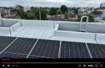
What was wrong with letting it land on top of the horizontal solar panels inside the edges of the roof? Looks a lot better there, than among the power lines below and on the street!
View attachment 158274
They weren't horizontal. They are at a angle. Probably would of been ok, if I had found it with find my drone.
 
It shouldn't. Once forced landing is turned off at 10%, it won't land at 10% even under autonomous RTH control. It will continue to keep coming home until the battery is completely exhausted, which what you want it to do, if it is over water or irretrievable if it lands anywhere else, other than back at the launch site or the current Home Point setting. The difference is that you don't have to fight the descent with full up left stick. It will maintain its RTH altitude until signal can be restored, or it reaches the Home Point and lands under RTH.
If I'm not controlling the drone, I want it to land softly rather than hard from 200 feet up.
 
Alternatively, do you want forced Autoland to set it down on a freeway that is between you and the drone? How about in the ocean? In a lake? A river? Over a cliff? In the street? I certainly don't! Let me control the drone!
Personally I do not fly over built up areas for that very reason, if I cross a road, isolated area, it's flown across as fast as possible.
I would not try to cross a road whilst in forced landing, if I have been (insert suitable word) enough to have been caught on the wrong side of a road etc. then that, in my opinion, is my fault and I must bear the consequences, better to ditch somewhere safe for others and lose the drone rather than endanger others and possibly risk legal troubles.
Most of my proper flights would be over the sea so losing the drone is always a possibility but over the sea or water I could afford to fly until motor stop and not endanger any one or property.
That said I have always had the drone back at the home point before forced landing kicked in and I think that is a wise precaution to take.
Flying/driving on an 'empty tank' "spoils the view" as an old Scot once said to my Dad.

And yes I have been all set to ditch a drone in the sea rather than have it blown over the village it was heading for, fortunately the gust died and I was able to get the drone home.
 
Last edited:
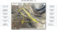
I was hired to shoot a "trolley" system at a mine proving grounds by the contractor that installed it. On Friday afternoon, he let me know he forgot to arrange to get onsite on a Saturday. I checked it out on Google Earth and decided I could shoot it from the public road.

As I concentrated on getting the shots, I forgot I was over a mile out. While returning against the wind, I had to keep the left stick up, so the drone didn't descend further and negotiated around the high points since I could not increase height. I kept it as low to the ground as possible to minimize damage if the battery gave out.

Landed with 1% battery left.

2022-12-15_16-30-14.jpg
 
  • Like
Reactions: MaxHam
I was hired to shoot a "trolley" system at a mine proving grounds by the contractor that installed it. On Friday afternoon, he let me know he forgot to arrange to get onsite on a Saturday. I checked it out on Google Earth and decided I could shoot it from the public road.

As I concentrated on getting the shots, I forgot I was over a mile out. While returning against the wind, I had to keep the left stick up, so the drone didn't descend further and negotiated around the high points since I could not increase height. I kept it as low to the ground as possible to minimize damage if the battery gave out.
Flying a long distance downwind, forcing a return against a headwind, staying out too long and then not flying directly back?
That's the perfect recipe for losing your drone.
 
I was hired to shoot a "trolley" system at a mine proving grounds by the contractor that installed it. On Friday afternoon, he let me know he forgot to arrange to get onsite on a Saturday. I checked it out on Google Earth and decided I could shoot it from the public road.

As I concentrated on getting the shots, I forgot I was over a mile out. While returning against the wind, I had to keep the left stick up, so the drone didn't descend further and negotiated around the high points since I could not increase height. I kept it as low to the ground as possible to minimize damage if the battery gave out.

Landed with 1% battery left.

View attachment 158290
So you made 6.5 miles on your risky flight. Was this a mavic 3? Since we can now fly out of signal range with waypoint flights, I'm wondering how far the mavic 3 can safely go. I'm also wonder what the most efficient speed is for long flights.
Glad you got home ok.
 
  • Like
Reactions: BroomRider
I'm wondering how far the mavic 3 can safely go.
According to the specs, 30 kilometres (total distance, not distance from the launch point).
But if you tried that in anything but laboratory conditions, it would not be safe.
I'm also wonder what the most efficient speed is for long flights.
If you mean the best speed for most distance, that's always full speed in Normal Mode.
But that's in windless conditions .. wind will change everything.
 
I guess I learned something. Can goto maybe 15% if your right by your home point, but no less.
Personally I try not to go below 20% and never go lower than 15%. I care too much for my batteries ($$) to abuse them too much. I want them to last. Yes, you were very lucky.
 
According to the specs, 30 kilometres (total distance, not distance from the launch point).
But if you tried that in anything but laboratory conditions, it would not be safe.

If you mean the best speed for most distance, that's always full speed in Normal Mode.
But that's in windless conditions .. wind will change everything.
So that's 20 miles, but that guy said he was down to 1% battery after 6.5 miles. Is there a program that tells you the total distance covered from a flight?
 
Personally I try not to go below 20% and never go lower than 15%. I care too much for my batteries ($$) to abuse them too much. I want them to last. Yes, you were very lucky.
Would this battery damage show up right away, or over a period of time?
 
So that's 20 miles, but that guy said he was down to 1% battery after 6.5 miles. Is there a program that tells you the total distance covered from a flight?
The max distance in the specs is for a drone flown, with no climbing, no changes in speed and no wind at all.
The drone in post #45 was flown with plenty of stopping and accelerating and came home into a significant headwind.
The total distance of the flight is one of many parameters shown in the recorded flight data.
For the flight in question, the distance covered was 10.28 kilometres.
 
  • Like
Reactions: GadgetGuy
Is there a program that tells you the total distance covered from a flight?
Does the summary in the flight records section of the app show the distance flown? I don't have a phone to hand to check. Besides, I don't have a Mavic 3 to check.
Airdata shows a flight distance but it can be confused if the drone does not have a good GPS count at the start of the flight. I have a couple of Mini 1 or 2 flights, very short flights, one under 50 ft, where the drone took off with poor GPS and airdata reported flight distances in the 100's of feet if not metres.
Flight distance used to be recorded in the .txt flight log but I think that stopped when the fly app was switched to encrypted logs, 1.2.4?
 
Last edited:
They weren't horizontal. They are at a angle. Probably would of been ok, if I had found it with find my drone.
That's not what the video shows. In this still frame, the solar panels are parallel with the flat roof surface. Do you have access to that roof to know differently? If so, why didn't you just land it on the gray roof section behind the solar panels, and retrieve the drone at your convenience?
1671190273765.jpeg
 
If I'm not controlling the drone, I want it to land softly rather than hard from 200 feet up.
RTH has its own soft landing when it arrives back at the Home Point. The only reason that would not be engaged is if you were able to regain control, and landed manually, or if the battery shut down on the way to the HP because it had no power left, which would happen whether or nor you were in control. It won't have a "hard landing" from 200 feet unless you screwed up, and tried to fly farther than the battery was physically capable of, under the circumstances, and were also flying at 200 feet!
 
I was hired to shoot a "trolley" system at a mine proving grounds by the contractor that installed it. On Friday afternoon, he let me know he forgot to arrange to get onsite on a Saturday. I checked it out on Google Earth and decided I could shoot it from the public road.

As I concentrated on getting the shots, I forgot I was over a mile out. While returning against the wind, I had to keep the left stick up, so the drone didn't descend further and negotiated around the high points since I could not increase height. I kept it as low to the ground as possible to minimize damage if the battery gave out.

Landed with 1% battery left.

View attachment 158290
You can still ascend under Autoland. It just ascends very slowly, which is why you must gain all necessary altitude needed to reach the HP before 10% battery is reached, which begins Autoland. You have from 15% to 10% to do so under normal control. Turning off Autoland in the parameters gives you that full normal control after 10% with no forced descent. When you landed at 1%, you still had well over 2 minutes of flight left at 27mph in no wind. Ideally, you want to land on a glide path of gradual descent towards the HP, with the ability to set it down anywhere along the route, if it becomes obvious that it won't make it back within 2 minutes of reaching 0%, which isn't really 0% anymore.
 
  • Like
Reactions: MaxHam
Would this battery damage show up right away, or over a period of time?
Batteries are not damaged by taking them down to even 0%, but doing so repeatedly will eventually shorten the maximum flight time obtained, just like all usage does. A good safe goal is to land between 5-10%, which minimizes battery stress, while maximizing flight time and safety. Repeatedly taking batteries down below 0%, which is still 3.5V per cell, will prematurely age them. Damage occurs when cells reach voltage below 3.0V, which is usually requires over 2 minutes of flight past 0%.
 
  • Like
Reactions: MaxHam
Does the summary in the flight records section of the app show the distance flown? I don't have a phone to hand to check. Besides, I don't have a Mavic 3 to check.
Airdata shows a flight distance but it can be confused if the drone does not have a good GPS count at the start of the flight. I have a couple of Mini 1 or 2 flights, very short flights, one under 50 ft, where the drone took off with poor GPS and airdata reported flight distances in the 100's of feet if not metres.
Flight distance used to be recorded in the .txt flight log but I think that stopped when the fly app was switched to encrypted logs, 1.2.4?
Flight distance is still recorded in all Fly app logs, as shown in your DJI Flight Logs on your device. Airdata can still read all the Fly app logs for all of their flight metrics and telemetry. However, any prolonged loss of signal can truncate or split the flight logs, as signal is required to transmit and record the changes in the drone location to the device during flight. Airdata tells you the max potential flight time separately for each battery after a flight, so you can gauge degradation, and learn changes in flight times based upon headwinds and temperature.
 
Flight distance is still recorded in all Fly app logs, as shown in your DJI Flight Logs on your device. Airdata can still read all the Fly app logs for all of their flight metrics and telemetry. However, any prolonged loss of signal can truncate or split the flight logs, as signal is required to transmit and record the changes in the drone location to the device during flight. Airdata tells you the max potential flight time separately for each battery after a flight, so you can gauge degradation, and learn changes in flight times based upon headwinds and temperature.
With regards to Airdata.
The problem I encountered with airdata's flight distance had nothing to do with loss of control signal, I had full signal through out these flights. The problem lies in weak GPS at the start of the flights concerned.
The airdata flight track initially showed the drone to be WELL away from its actual location. The actual location being right outside my house so I know the locations, indicated and real, quite well.
Once the drone obtained sufficient GPS to establish the home point etc. the track instantaneously jumped from the erroneous location to the correct one.
The problem being that the jump distance was included in the distance flown indicated by airdata. In one flight I literally flew the drone in through the door, through the hall, up the stairs and along the landing. I doubt the distance actually flown in that flight was more than 50-60ft yet the log indicates a distance flown to be in excess of 500ft.
I have 8 flight marked with "haha" with respect to the distance flown.
From memory, in those flights, the Phantomhelp flight track does not start until the home point is established.
Yes, weak GPS or lack of a HP will, of course, also affect any calculated distances. Fortunately, those Mavic 3 problems are now behind us. I don't fly indoors much, and if I did, I would't expect the calculated distance indoors to be very accurate, especially without a recorded hole point. Similarly, I use a Bad Elf Pro+ as a portable GPS tracker, and if I don't let it first find sufficient satellites before starting the GPS logging, the start point can be off. Using it inside buildings and under bridges certainly messes up the tracks. It also calculates straight lines between all recorded points, even though it may have been a right angle turn, so it establishes a minimum distance rather than a completely accurate distance. One errant point can also throw everything off. It once recorded a single point at 5,000 feet ASL, at 500mph, on a bike ride! That was my "haha" file!
 
  • Like
Reactions: Yorkshire_Pud
Lycus Tech Mavic Air 3 Case

DJI Drone Deals

New Threads

Forum statistics

Threads
131,000
Messages
1,558,759
Members
159,985
Latest member
kclarke2929