My grandfather had a saying he gave me when I was a youngster in my single digits, learning to row a boat on the DE river, “Never travel farther from the shore than you are able to swim.”
Full sized (military?) aircraft pilots have an Alpha-Bingo fuel flight time rule when flying over water (for instance). Alpha is the fuel (i.e., the time you have to remain in the air) that you carry at the start of the flight, & Bingo is 2/3 the level, & dictates the point when a return is required. The remaining amount is there to help account for unforeseen difficulties (i.e., headwinds) that might be encountered on the way back.
Early in my flights with my new
M3P, I wanted to see how far it would fly, & I got a pretty good indication, & a lesson too (every flight is a “schooling”, for me at least).
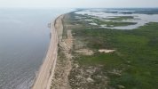
The wind was mild & coming onshore (


), & I flew from Broadkill Beach to Roosevelt Inlet (this is in Sussex County, Delaware). I had to gradually increase the altitude to maintain the signal strength, on up to the maximum of 400' along the latter portion of the distance. I hovered a wee bit to choose a good pic, took it, & about then, the battery level RTH kicked in, which was a good thing as the signal strength was also pretty low. I wasn't going to argue with it!
What I learned was, it wouldn't take me back along the route I took on the way there, which was along & over the open beach & thus, in a long & gradual curved route, where I could have taken a (long!) walk to go fetch it in case something bad happened.
Instead, it took me back in a direct line, which took me out over the open (Salt!) water. White knuckles time! I'd never flown that far before & neither had I flown over water before. But, since I didn't deny the RTH & the wind was coming onshore at a ~90 degree angle to the flight path, I made it back safely. I didn't want to mess with anything on the way back, me being a noob at flying a drone, & being over (Salt!) water.
If I had canceled the RTH, likely I would have turned the drone into a submarine on a 1-way trip to the bottom.
If I recall correctly, the 1-way distance was somewhere ~>5 miles. You can look up the locations on the interweb & check for yourself.
A similar test was done in the opposite direction, similar M.O. & this again from the same starting point, towards Fowler Beach, as I recall, somewhere ~>6 miles 1-way.
At no time was I flying over anyone or anything that, if something bad happened, I couldn't have chosen a safe landing spot on the way down. (Not that salt water is safe, but it's better that than hurt someone or damage property!)
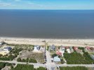
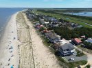
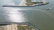
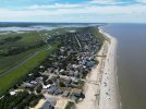
The photos below are, in order, my starting point (looking ~NE), en route ~SE, the inlet (looking ~SE), 2nd en route (looking ~NW) & ~Fowler Beach (looking ~SE).
I think that I picked a good location, & weather.