DJI Mavic, Air and Mini Drones
Friendly, Helpful & Knowledgeable Community
Join Us Now

Altitude Angel Flight Plan

Ralphco

Member
Joined
Dec 22, 2019
Messages
5
Reactions
4
Age
59
Location
Melton Mowbray, Leicestershire. United Kingdom.
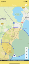
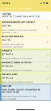
Hi, I’m down in Spain at the moment and using altitude angel to ensure I am able to fly my drone in the area. When I check my location it’s yellow (caution) and shows it as “Regulated airspace” and lists “exercises”. I submitted a flight plan but the time has elapsed and my request is still showing as pending with the phrase “you are not cleared for take off, your approval is pending”. This has now happened twice and I’ve not flown. Anyone have any ideas? Am I required to submit a flight plan if I am flying up to a maximum of 100 feet and have permission from the home wonders whose properties I will be photographing. Can I fly and take the usual precautions and follow normal drone regulations and rules re distances, involved people, other aircraft etc?
 
Have not a clue what "Altitude Angel" can provide ... but as I understand it, they are a 3:rd party provider, not any authority when it comes to Spain's airspace. As Spain have pretty hefty fines if flying unauthorized in restricted areas I would do a proper homework before take off.

In Spain AESA is the air space authority, nobody else, their drone site here:
Drones | AESA-Agencia Estatal de Seguridad Aérea - Ministerio de Fomento

As you doesn't say where in Spain you intend to fly you need to confirm the possibilities & requirements yourself.

This is the interactive drone map AESA provide:
ENAIRE Drones

Appears to be a lot of zones to consider depending on where you intend to fly ... & no, the owners of the property usually can't decide anything regarding the airspace even though it's above/around their property.

1649434766333.png
 
I am located where pin is, I think I’m good to fly ????
Don't know how you come to that conclusion?

As said earlier ... you are looking at a 3:rd party app & that isn't authoritative.
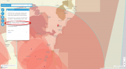
You need to look at AESA's drone map I linked to earlier ... and that says as per below.

From a quick glance I wouldn't fly ...

(Click on the picture to make it larger)
1649582790033.png
 
Lycus Tech Mavic Air 3 Case

DJI Drone Deals

New Threads

Forum statistics

Threads
131,097
Messages
1,559,828
Members
160,080
Latest member
KevinStudent