DJI Mavic, Air and Mini Drones
Friendly, Helpful & Knowledgeable Community
Join Us Now

Altitude readings?

Ponz

Active Member
Joined
Dec 7, 2022
Messages
33
Reactions
22
Age
70
Location
KCMO, MO, USA
I just bought a used Mini 2. Here's my question:

If I take off from a cliff or some other high point and the altitude is, let's say, 10'. Then I proceed forward off the, let's say, 200' high cliff. What would the altitude reading be? 10' or 210'

I can see where this would make a difference regarding the 400' ceiling law.

Thanks
Ponz
 
If you fly over the cliff at 10' feet you're only 10' agl, but once you go over the cliff, don't look down. Because then you're going to fall. When you fall into the ground you'll leave a hole in the shape of your body. And then you'll come out making an accordion noise.

To view this content we will need your consent to set third party cookies.
For more detailed information, see our cookies page.

Technically, when you go off the cliff and the bottomless pit below, you'd be going way over 400' agl most likely. Although it can happen in some places, most aircraft are not trying to fly around in tricky places, but as far as the quad it is most likely going from the starting point as a reference. The gps will still be reading msl and won't be aware of the difference in terrain.
 
I just bought a used Mini 2. Here's my question:

If I take off from a cliff or some other high point and the altitude is, let's say, 10'. Then I proceed forward off the, let's say, 200' high cliff. What would the altitude reading be? 10' or 210'

I can see where this would make a difference regarding the 400' ceiling law.

Thanks
Ponz
210 AGL
1671461782348.jpeg
B52-D
 
@Ponz the reading shown on the screen is the height of the drone above the home point
it has no bearing on the actual height of the drone ,once you go over the edge of the cliff
of course if you were flying in a fairly level area, then the height shown on the screen as you flew around, would be a fairly accurate indication of your actual height
 
Drone altitudes are always relative to the takeoff point (unless very low and vps kicks in).

Its a QFE.
 
  • Like
Reactions: Geofff
The indicated height ( determined by barometer ) is relative to the launch point, and ONLY the launch point.
So flying at an indicated height of 10ft will produce a horizontal flight and when over the ground beyond you cliff it will STILL indicate a height of 10ft.

When it is above the range of the downward looking sensors ( VPS and or IR sensors on the bottom of the drone ), the mini 2 has no way of knowing its height above the ground ( AGL ).
Even when the ground is within range of those sensors there is NO display of AGL and all you see is the height as determined by the barometer.

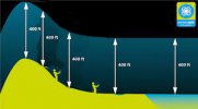
The legal height limit is a different matter entirely, if your legal height limit is 400ft then imagine a 400ft long piece of weighted string tied to the bottom of the drone. That string MUST theoretically ALWAYS be in contact with the ground beneath the drine.
 
Last edited:
Thanks all. As I suspected. I didn't really think the drone would be that smart but was curious anyway.

Ponz

ps - of course I meant if the drone was flown forward! har de har har.
 
What would the altitude reading be? 10' or 210'
The altitude would technically be 210', but the drone is going to show 10'. And if the drone is close enough to the ground (about 32 feet or less), you'll also be able to see the actual altitude from the downward sensors.
 
  • Like
Reactions: Ponz
The altitude would technically be 210', but the drone is going to show 10'. And if the drone is close enough to the ground (about 32 feet or less), you'll also be able to see the actual altitude from the downward sensors.
Given that: if I fly off a tall cliff/mountain and lower the drone to under 32' (to the valley floor) it will, basically, reset itself and give an accurate altitude reading from the valley floor?

Ponz
 
if I fly off a tall cliff/mountain and lower the drone to under 32' (to the valley floor) it will, basically, reset itself and give an accurate altitude reading from the valley floor?
No. The altitude will continue to show the current distance above the takeoff point for the entirety of the flight.

When the downward sensors are close enough to "see" the ground, that distance will display as a separate value at the bottom of DJI Fly.
 
No. The altitude will continue to show the current distance above the takeoff point for the entirety of the flight.

When the downward sensors are close enough to "see" the ground, that distance will display as a separate value at the bottom of DJI Fly.
Also you probably wouldn't want the value to reset it it is not also adjusting the return to home height (ie whack into the side of a hill). Though technically you could inadvertently be going over legal height if you're down in a valley and it ascends to 200ft above take off point to return to home and then you end up with a 600~700 feet high height as it comes back home.
 
Also you probably wouldn't want the value to reset it it is not also adjusting the return to home height.
Right -- resetting it to the last location where the ground was detected wouldn't be any more useful. Either way you go, you'd still have to scout the area before the flight to understand the altitudes at play in the planned flying location.
 
Given that: if I fly off a tall cliff/mountain and lower the drone to under 32' (to the valley floor) it will, basically, reset itself and give an accurate altitude reading from the valley floor?

Ponz
No, the height will simply show negative, you would have to land to reset the height (I can't remember if it zeros on motor stop or take off but it will be reset by a landing and motor stop and subsequent take off. It's one of the theoretical ways of climbing a tall mountain. And then, as pointed out, you could be in difficulties.
My lowest is -300+ft off the top of a sea cliff and from memory others have gone far lower than that.

You also need to be aware that there can be other problems associated with going way down low, into, say, a canyon.
I can't remember the reasons behind it but something about loss of GPS rings a bell but I could be wrong. At least one member here or on the DJI forum been unable to get their drone to climb out of the canyon where they were and where they had descended, even though the drone never landed.
They ended up having to fly along the canyon to reach a low point of the rim and just clear that rim to land at the roadside.
 
  • Like
Reactions: Ponz
No, the height will simply show negative, you would have to land to reset the height (I can't remember if it zeros on motor stop or take off but it will be reset by a landing and motor stop and subsequent take off. It's one of the theoretical ways of climbing a tall mountain. And then, as pointed out, you could be in difficulties.
My lowest is -300+ft off the top of a sea cliff and from memory others have gone far lower than that.

You also need to be aware that there can be other problems associated with going way down low, into, say, a canyon.
I can't remember the reasons behind it but something about loss of GPS rings a bell but I could be wrong. At least one member here or on the DJI forum been unable to get their drone to climb out of the canyon where they were and where they had descended, even though the drone never landed.
They ended up having to fly along the canyon to reach a low point of the rim and just clear that rim to land at the roadside.
What about the RTH feature?

The RTH feature wouldn't work. The drone would then smack into a hill or cliff - right?
 
The RTH feature wouldn't work. The drone would then smack into a hill or cliff - right?
Nope. The drone would fly up to 0 feet (if currently below the takeoff point) -- and then up to the RTH altitude before flying back to the home point.
 
  • Like
Reactions: Ponz
What about the RTH feature?

The RTH feature wouldn't work. The drone would then smack into a hill or cliff - right?
RTH height is relative to the take off point.
So, if you set an RTH height of 70 ft, launched and then descended to -300ft, all WITHOUT LANDING etc. and without any 'canyon problems', and then trigger an RTH, the climb will be 370ft........ to +70ft relative to the launch point.

BUT if you landed at -300ft then the subsequent RTH height would be at 70ft above the NEW launch point i.e. 230ft below the original launch point and it would RTH to the NEW launch point, NOT the original launch point.

However you can reset both the home point and the RTH height at any time with one exception, you can not reset RTH height if the drone is EXECUTING an RTH, been there and done that.
You can however reset the homepoint whilst a drone is executing an RTH and some people have proposed that and possibly used that, as a way of creating a way point flight .
 
  • Like
Reactions: okw

DJI Drone Deals

New Threads

Forum statistics

Threads
134,606
Messages
1,596,745
Members
163,102
Latest member
Meric
Want to Remove this Ad? Simply login or create a free account