DJI Mavic, Air and Mini Drones
Friendly, Helpful & Knowledgeable Community
Join Us Now

B4UFLY and DJI Fly Spots

goneeuro

New Member
Joined
Aug 25, 2022
Messages
2
Reactions
5
Age
41
Location
Venice, FL, USA
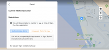
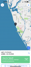
Good Afternoon all! I just recently bought my very first Drone. The DJI Mini 2. I am still learning all the ins and out on what is allowed and ran into an issue. I live in Venice FL and have a local airport on the island. In the DJI app it has the beach under "Enhanced Warning Zone" and "Authorization Zone", but B4UFLY does not show any restrictions. Our Airport is pretty busy so I am SURE there is some kind of issue with flying on the beach here. Can you guys help me understand why DJI says no and B4UFLY says go for it? I am posting a couple of screen shots of what I am seeing on my phone.IMG_2146.PNG
IMG_2145.PNG
IMG_2144.PNG
 
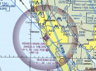
B4UFly appears to be correct according to the Miami Sectional chart. The markings for the local airport in this case show a manned tower but no airspace restrictions below 700' AGL (above ground level).

The wide maroon band depicts Class E airspace starting at 700':

Screen Shot 2022-08-25 at 1.04.34 PM.png
 
This is a terribly frustrating issue for many pilots. DJI may prevent you from flying or require "permission" even when the FAA could care less and to top it off you may find situations where you have no cell coverage and unable to GET permission from DJI even when it is not restricted. It's just a crazy situation at times.
 
B4UFly appears to be correct according to the Miami Sectional chart. The markings for the local airport in this case show a manned tower but no airspace restrictions below 700' AGL (above ground level).

The wide maroon band depicts Class E airspace starting at 700':


Thanks for the response. I was not planning on going any higher than 100ft or so. Or even that high. In my screen shot of the b4ufly app it looks like just going up to Nokomis Beach may be the safer bet just to keep out of trouble.

I plan on taking the Part 107 just to learn more, but in the mean time, I didnt want to break any laws just getting used to things.

Thanks again all for your help with this.
 
yea DJI seems to over push their boundaries some times. wish they'd get with the program or at least mind their own business :rolleyes:
 
I frequently fly within 5 miles of Hunter Army Airfield in Savannah, GA at a local city park. Hunter AF is slap in the middle of our city and every single military branch flies thru here. C130s are a daily occurrence.

When I received the warning/request for permission to fly in restricted air space with my new m3, I had to have a code sent to controller/phone the second I attempted to fly. It took like 60 seconds and I was allowed to then fly under 200' that close to Hunter AF. When I go back to the house just 3 or 4 miles away from there (about 8 miles from Hunter) I receive no warnings and can fly my normal 400'.

I have B4ufly installed but haven't noticed a difference between that app and the DJI fly app... its a better map. I just deal with the DJI fly app.. Of course, no telling what DJI is saying in your neck of the woods but it seems pretty problem free here in Savannah.

I would say go fly. Maybe keep it under 200' to have a little confidence that you're not breaking any laws.. Good luck and welcome.
 
This is typical dji get used to it. You will find they randomly prevent you from flying while the FAA has no problem.
I guess in their country you don't question them comrade.
 
  • Haha
Reactions: Bob in Savannah
Thanks for the response. I was not planning on going any higher than 100ft or so. Or even that high. In my screen shot of the b4ufly app it looks like just going up to Nokomis Beach may be the safer bet just to keep out of trouble.

I plan on taking the Part 107 just to learn more, but in the mean time, I didnt want to break any laws just getting used to things.

Thanks again all for your help with this.
B4YouFly is the authority. If it says you're ok to fly, you're legally ok with the FAA. DJI seems to put restrictions around all airports, in line with the runways. You should be fine flying in the marked location, particularly if you're staying below 100' AGL. Do be aware of air traffic, though.

I've not seen the prompt you show in the screen captures. Have you set up an account and registered your drone with DJI in the FLY app yet?

Good on you for being aware of airspace limitations and being responsible enough to investigate before flying. Welcome to the forum. It's a great resource. Ask questions, jump into the discussions, and share what you shoot.
 
B4UFly appears to be correct according to the Miami Sectional chart. The markings for the local airport in this case show a manned tower but no airspace restrictions below 700' AGL (above ground level).

The wide maroon band depicts Class E airspace starting at 700':

View attachment 153881
Actually, part of that is incorrect: There's no control tower here. If there was a control tower, the airport symbol would be blue; the magenta symbol shown above means there's no tower there.

"AWOS-3" means there is recorded weather and other info continuously broadcast on 119.275. That's not a control tower, that's just an automated, recorded broadcast (mostly the current weather), repeated and rebroadcast every minute or so.

"122.725" is the CTAF - Common Traffic Advisory Frequency, again, not a "tower", not staffed, it's just the designated frequency for pilots using the airport to talk to each other. The "C" in the magenta circle following the frequency tells you that's the CTAF.

If you look up this airport listing in official FAA publications (or things that use use that as a source), the following remarks are noted: "Parasailing activity west of the airport along beach"..."Airport has extensive flight training." <- Be careful about that, there are lots of small airplanes (many flown by student pilots) that will be operating close in. Probably lots of small airplanes doing touch-and-goes (practice landings) over and over again, from the surface up to 1100 feet. The airport has fairly big runways, so probably gets some larger planes, too, twins and the occasional small jet.

You may be legal flying very low nearby. But you know, just because you can do something it isn't always a great idea to do it. You've got to also use some common sense. Personally, I would not fly my drone anywhere right next to the field. I'd go a little ways up or down the coast (maybe a half mile or so), stay very low (as you suggested, 100') and keep a sharp eye out for airplanes. Please be careful around any airport.
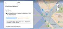
 
Good Afternoon all! I just recently bought my very first Drone. The DJI Mini 2. I am still learning all the ins and out on what is allowed and ran into an issue. I live in Venice FL and have a local airport on the island. In the DJI app it has the beach under "Enhanced Warning Zone" and "Authorization Zone", but B4UFLY does not show any restrictions. Our Airport is pretty busy so I am SURE there is some kind of issue with flying on the beach here. Can you guys help me understand why DJI says no and B4UFLY says go for it? I am posting a couple of screen shots of what I am seeing on my phone.View attachment 153878
View attachment 153879
View attachment 153880
Greetings from Birmingham Alabama, welcome to the forum! As MS Cost mentioned, B4YouFly is the FAA's approved app and I would suggest relying on it.
 
I thought there was a way to report to DJI when their data base and the FAA permissions don't line up. Supposedly, they can update that in their frequently updated "Fly Safe" maps.
 

DJI Drone Deals

New Threads

Forum statistics

Threads
134,590
Messages
1,596,593
Members
163,095
Latest member
srchipiron
Want to Remove this Ad? Simply login or create a free account