DJI Mavic, Air and Mini Drones
Friendly, Helpful & Knowledgeable Community
Join Us Now

Baro. Alt vs. Sonar Alt in AirData

maggior

Well-Known Member
Joined
Mar 29, 2021
Messages
631
Reactions
855
Location
New Jersey
I am a new Mavic Air 2 owner and I started uploading my flight data to AirData. I find it really interesting to look at and play the flight back.

I noted that there are two altitude measures, barometric and sonar. The sonar altitude doesn't seem to make any sense. Googling seems to indicate this is related to height over water. Is it a case where sonar alt is only relevant when flying over water?

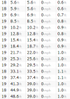
Here is a snapshot of one of my logs. I have no problems flying so there doesn't appear to be anything wrong.

Thanks!
1618101521356.png
 
It's not specifically an issue of being over water. The downward sensor on the Air 2 is infrared, and once the height exceeds the maximum range of the sensor it just continues to report that same height. What you should check is whether it is reporting correctly at heights less than 39 ft.
 
It isn't . I could post an example of that.
The sonar measurement shows actual height above ground, as long as the sensor is still within operating range of the ground.

The drone's barometric sensor registers and records zero height at takeoff. It measures barometric altitude referenced to that zero takeoff height.

Take off and hover a few feet off the ground. The sonar and barometric heights should match fairly closely. If you then fly up a gradually upward sloping hillside, the sonar display would remain constant if you maintain the same height above ground, whereas the barometric display will show a steady increase in height as the drone climbs higher than its takeoff location.

The barometric altimeter is very sensitive to changes in barometric pressure. As you climb or descend the barometric pressure changes. But it also changes quite a lot due to other environmental influences, like temperature. So when you return to land at your same takeoff location, the barometric altimeter may no longer accurately display your landing location as zero height.

In real aircraft there is a manual adjustment knob on the altimeter to compensate for changes in local barometric pressure. Part of the startup checklist is to ensure your altimeter setting is correct to accurately display the Above Sea Level height of your airport. When flying to a different airport, the tower will tell you their current altimeter setting as it is often quite different from where you took off from.

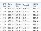
Thanks everybody, you've been very helpful. I examined the data from the start of my flight yesterday and both altitude measurements are virtually the same until the drone reaches a height over 39 feet. At that point, that barometric altitude value continues to rise and the sonar altitude remains at 39 feet.

Here's a snippet for anybody interested. Obviously I was remembering incorrectly that the values didn't match from 39 ft. or below.

1618154076545.png
 
  • Like
Reactions: Zbip57
A little off topic.....when I check my flight log in airdata, I only show altitude, there is no differentiation for bar. or sonar?
Is there some way of choosing which parameters displayed in the flight log? BTW, I'm flying a MA2...
 
A little off topic.....when I check my flight log in airdata, I only show altitude, there is no differentiation for bar. or sonar?
Is there some way of choosing which parameters displayed in the flight log? BTW, I'm flying a MA2...
Are you looking at the spreadsheet data?
It should be there.
Click on the download CSV link.
 
Lycus Tech Mavic Air 3 Case

DJI Drone Deals

New Threads

Forum statistics

Threads
131,732
Messages
1,565,745
Members
160,586
Latest member
LBRO