You are using an out of date browser. It may not display this or other websites correctly.
You should upgrade or use an alternative browser.
You should upgrade or use an alternative browser.
Can Changing Landforms Cause Altitude Violation?
- Thread starter 55Kevy
- Start date
@55Kevy yes, the max altitude above the ground is where the drone is so you would be at nearly 500 ft when you flew out
Altitude regulations refer to the altitude of the drone above the ground below it.Since the drone measure barometrically its altitude from the takeoff point (which is 0) if one were to fly to 390 ft and then fly on a level plane over a 100 ft deep wash or gully, would that be a violation?
Kevin
Where it was launch ed from is irrelevant.
Interficiam Stercore
Well-Known Member
Yes, it's a violation. But, and there is a but. Are you going to get in trouble? If you hit an aircraft, you might. How likely would that be? Maybe as likely as you winning the lottery. If the ATSB actuallly got ahold of your flight logs, they would still show you flying at less than 400 feet. They would then have to compare the impact location with ground elevation maps. Would they go that far? If there were deaths, perhaps, but a hit, maybe not. Again, you would have to hit a manned aircraft for you to be investigated.Since the drone measure barometrically its altitude from the takeoff point (which is 0) if one were to fly to 390 ft and then fly on a level plane over a 100 ft deep wash or gully, would that be a violation?
Kevin
Lastly, lets say you posted your flight with all the flight data showing, like a screen capture does. Then, your video shows you flying (at around 396ft) over a deep wash gully, or maybe a canyon, and you don't reduce flight altitude, you could get in some trouble, if an FAA agent actually reviewed the video for some god for saken reason. Maybe a complaint perhaps? Then you might see some trouble come your way. That's my 5 cents. LOL. I'm just bored, writing scenarios that are highly improbable.
Anyone who can read flight data could tell in a minute how high the drone was above the ground below it.If the ATSB actuallly got ahold of your flight logs, they would still show you flying at less than 400 feet.
But no-one is investigating flight data looking for such trivial things unless there's a serious incident.
B52-D
Well-Known Member
Last edited:
MARK (LI)
Well-Known Member
There are quite a few Youtube videos that give you the basics of flying drones in easy to comprehend language and illustrations, such as the one above...you can learn a lot from them...there are a lot of other regulations that you may not be aware of ......you should look into the videos
dronerdave
Well-Known Member
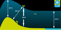
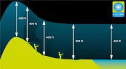
That image has always been a bit confusing IMO. If you let the angled line free fall, it would have to be more than 400 feet. It's the altitude directly below the aircraft that counts. Really it should be like this:In my opinion, you would be be busting your altitude restriction. This illustration supports my opinion.
View attachment 133543
B52-D
Blue Skys & Happy Contrails.
View attachment 133544

MARK (LI)
Well-Known Member
That image has always been a bit confusing IMO. If you let the angled line free fall, it would have to be more than 400 feet. It's the altitude directly below the aircraft that counts. Really it should be like this:
Not confusing...just wrong...as you point out the altitude is straight down under the aircraft...nice clean job editing and correcting it @dronerdave
That image is from a UK site (Introduction - Dronesafe) and it is correct for the UK rules, nothing confusing about it, really. USA rules are slightly different and that's where confusion may set in - expecting a UK website to apply to another country's laws.That image has always been a bit confusing IMO. If you let the angled line free fall, it would have to be more than 400 feet. It's the altitude directly below the aircraft that counts. Really it should be like this:
View attachment 133572
In the UK you just need to keep within 120m of the ground, whether that be vertically or horizontally. For example you could fly 100m out off the edge of a very tall cliff and remain legal, even though your drone's altitude above ground is, say, 500m.
dronerdave
Well-Known Member
Exactly but the OP is from the USA.That image is from a UK site (Introduction - Dronesafe) and it is correct for the UK rules, nothing confusing about it, really. USA rules are slightly different and that's where confusion may set in - expecting a UK website to apply to another country's laws.
In the UK you just need to keep within 120m of the ground, whether that be vertically or horizontally. For example you could fly 100m out off the edge of a very tall cliff and remain legal, even though your drone's altitude above ground is, say, 500m.
cgmaxed
Well-Known Member
Like this one. Right?That image has always been a bit confusing IMO. If you let the angled line free fall, it would have to be more than 400 feet. It's the altitude directly below the aircraft that counts. Really it should be like this:
View attachment 133572

- Joined
- May 25, 2017
- Messages
- 8,491
- Reactions
- 7,976
- Age
- 61
if one were to fly to 390 ft and then fly on a level plane over a 100 ft deep wash or gully, would that be a violation?
Very technically yes, but it would depend a bit on the actual land feature (gully).
If deep but quite narrow then it should be of no consequence, if the Grand Canyon size feature then yes, as helicopters can technically travel into it.
Even then, it would probably need to be that sort of touristy place I guess for helis to want to fly low through it.
If it was a 100' wide x 100' deep washout on some non descript plain, it's not something an aircraft is going to be taking into any account in their flight plans, a tiny blip to all concerned.
It's all relative guess work on some terrain, eg going up / down that hillside on a flight, as per the diagrams above.
You can't know for sure what altitude is under you while going up or down following a hillside, even with a lot of pre trip map consulting, only give it your best estimate to legal altitude.
Some would say err on the die of caution there, while some situations airspace authorities aren't going to be hunting you down if you were 20, 30, 50' or wahtever over 400' briefly.
Unless you hit a plane or heli, not terribly likely if you are VLOS and paying attention.
Just watch this one . . .

Thank you all for your responses. I doubt that I'll ever find myself in such a situation, but I've seen some videos of flights over river canyons that were spectacular and it got me wondering.
smashse
Well-Known Member
For part 107 (not positive about Hobby/rec/TRUST flights), it is also considered 400' from a structure, so it actually lags a touch from the hill. I don't have a nifty illustration, but if you are within 400' from a cliff, you can actually go 400' above the height of the top of the cliff. I know some may disagree, because the FAA says "within 400' of a structure" but they never say man-made or natural structure. A cliff or tower makes more sense in explaining what I am saying.
Say you have a 200' cliff to the ocean, and you are flying 80' from the cliff over the water, your max altitude would actually be 400' over the cliff, or 600' MSL, even though your drone is over the water. Your drone is technically at that point 600' AGL viewed directly down, but because of the proximity of the cliff, you are allowed that.
This was confirmed by an FAA licensed flight instructor... Twice just to make sure he knew what I was asking. I have not yet found anything official that contradicts that.
For your river canyons, if they aren't 400' wide, you can use the elevations of the cliffs/banks for ground 0.
MARK (LI)
Well-Known Member
That cliff is part of the topography...it is not a structure...I did see where you say a CFI confirmed that....but a CFI teaches how to fly manned aircraft...and I surmise that he is well versed in the rules that apply to them...this is not manned aircraft and has its own different set of rules
Last edited:
I would say that it depends.Since the drone measure barometrically its altitude from the takeoff point (which is 0) if one were to fly to 390 ft and then fly on a level plane over a 100 ft deep wash or gully, would that be a violation?
Kevin
107.51 (b) lays out the requirement for a 400' AGL ceiling. However, the same section also makes allowances for structures. i.e. If you're within 400' of a structure and you are no more than 400' above the structure's immediate uppermost limit, then you are ok.
Taken in this context, I would say that as long as the gully is less than 799.99999' wide (less than 400 radius from each side of the gully), you're fine. I wouldn't try it over the grand canyon (if one were able to do so).
I would respectfully disagree.That cliff is part of the topography...it is not a structure...I did see where you say a CFI confirmed that....but a CFI teaches how to fly manned aircraft...and I surmise that he is well versed in the rules that apply to them...this is not manned aircraft and has its own different set of rules
First, I would note the definition of structure is fairly broad. There are rock structures, for example, that are completely manmade. Had the rule meant "only" man-made structures, they probably would have said so.
Second, I would look at the various approved training materials, which all note that an sUAS can increase MSL altitude while maintaining 400' AGL when going over a hill.
Last, I think that if there were a mountain or cliff in front that were more than 400' high, part 107 doesn't mandate that you must crash into it. A reasonable interpretation is that you would be allowed to fly over it, just as you would do for a man made structure.
Anyhow, that's my two cents.
There are plenty of FAA examiners on here who will, no doubt, correct me if my understanding is mistaken.
MARK (LI)
Well-Known Member
Keeping it a friendly discussion....the 400' ceiling is AGL....there are places....probably most of the country where you can be over 400"MSL at launch .......with a mountain...you can follow the topography and maintain the 400' AGL.....with a cliff..if you were to ascend ..go higher than the cliff and go forward.....now you are BVLOS...I would respectfully disagree.
First, I would note the definition of structure is fairly broad. There are rock structures, for example, that are completely manmade. Had the rule meant "only" man-made structures, they probably would have said so.
Second, I would look at the various approved training materials, which all note that an sUAS can increase MSL altitude while maintaining 400' AGL when going over a hill.
Last, I think that if there were a mountain or cliff in front that were more than 400' high, part 107 doesn't mandate that you must crash into it. A reasonable interpretation is that you would be allowed to fly over it, just as you would do for a man made structure.
Anyhow, that's my two cents.
There are plenty of FAA examiners on here who will, no doubt, correct me if my understanding is mistaken.
I think loose interpretation of the rules will just get someone in trouble
And attempting a strict literal interpretation of the rules always ends up in pointless about flying over a hypothetical cliff edge like this.I think loose interpretation of the rules will just get someone in trouble
The rules are brief and can't spell out in fine detail what applies in a specific extreme situation like that.
Common sense is needed.
If you fly 10 ft, 20 ft or even more out over the edge of a 1000 ft cliff, you won't be getting in the way of any manned aircraft and no-one is going to be chasing you for reckless flying.
Similar threads
- Replies
- 9
- Views
- 743
- Replies
- 27
- Views
- 3K
- Replies
- 6
- Views
- 693
DJI Drone Deals
1. Mini 2
2. Mini 3 Pro
3. Mini 4 Pro
4. Air 2s
5. Air 3
6. Avata 2
7. Mavic 3 Pro
8. Mavic 3 Classic
2. Mini 3 Pro
3. Mini 4 Pro
4. Air 2s
5. Air 3
6. Avata 2
7. Mavic 3 Pro
8. Mavic 3 Classic
New Threads
-
-
-
Mini 3 Cargill's Leap, Blairgowrie, Perthshire
- Started by AlbionDrones
- Replies: 5
-
-


