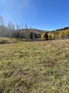
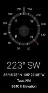
You must have made some mistake when you transferred the coordinates to the geological maps you speak of ...You are correct that the points are displayed on the map properly, both home point and landing point and the course of the flight. But the coordinates describing those points are inaccurate. They are both out west of Taos Pueblo, not on the west slopes of the Sangre de Cristos. Plot those coordinates on the USFS or geological service maps and see where you are. Mobilehomer found the correct coordinates in the KML file.
You say that this is a correct plot of the flight you did in the right place..? This is taken directly from what you shared from Airdata in the first post (the Airdata .KML file downloaded & shown in Google Earth).

Below is the .CSV file from your flight (the Airdata .CSV downloaded & shown in Excel). Have marked the last known coordinate on the last row there...

And here I've dropped a red pin with the last coordinate from the .CSV file above in Google Earth ... & the pin perfectly line up with where the flight path ends.