


- Joined
- Apr 11, 2018
- Messages
- 175
- Reactions
- 82
- Age
- 65
Hopefully I'm asking the right question...
I have a simple route flying in a straight line due north from A to B over a garden with some paths and fencing that are laid out N<>S and W<>E (checked w/ compass). Heading in mission hub indicates expected 0°. I've 3 versions of this mission; 1) Both waypoints set to POI-1 which is on the path, 2) interpolate (-50° gimbal), and 3) interpolate (-50° gimbal) w/ POI set to 'none'. Overall results are as expected with the first video staying close to POI-1 and the other two identical with a fixed down gimbal.
In all 3 the Mavic, though flying and following the 0° path correctly, is aimed or pointed about -10° so while flying to 0° it is pointed at about 350° and so images are cocked a bit.

Airdata indicates that it is flying correctly:

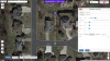
Screen Grabs:


You can see how the fence lines are not straight up and down as expected. I've had this same issue at other locations. I've done both Compass and IMU calibrations. Should I do them again even though it seems to be flying the route quite accurately? Is there another adjustment that I should look at?
Also:
- When I take off it doesn't go straight up and one time today it rotated about -90° as it rose to 10m.
- I cannot get precision RTH to work. On take-off I go up slowly to about 11m and hover for a while. If I press RTH on Litchi it comes back close and then starts circling rather fast. If I press RTH on the mavic RC it comes back and lands but about 20' east of the landing pad (orange circle in grass).
Thanks all,
I have a simple route flying in a straight line due north from A to B over a garden with some paths and fencing that are laid out N<>S and W<>E (checked w/ compass). Heading in mission hub indicates expected 0°. I've 3 versions of this mission; 1) Both waypoints set to POI-1 which is on the path, 2) interpolate (-50° gimbal), and 3) interpolate (-50° gimbal) w/ POI set to 'none'. Overall results are as expected with the first video staying close to POI-1 and the other two identical with a fixed down gimbal.
In all 3 the Mavic, though flying and following the 0° path correctly, is aimed or pointed about -10° so while flying to 0° it is pointed at about 350° and so images are cocked a bit.
Airdata indicates that it is flying correctly:
Screen Grabs:
You can see how the fence lines are not straight up and down as expected. I've had this same issue at other locations. I've done both Compass and IMU calibrations. Should I do them again even though it seems to be flying the route quite accurately? Is there another adjustment that I should look at?
Also:
- When I take off it doesn't go straight up and one time today it rotated about -90° as it rose to 10m.
- I cannot get precision RTH to work. On take-off I go up slowly to about 11m and hover for a while. If I press RTH on Litchi it comes back close and then starts circling rather fast. If I press RTH on the mavic RC it comes back and lands but about 20' east of the landing pad (orange circle in grass).
Thanks all,
Attachments
Last edited:


