

Australia hey, we can have fires the size of small Countries going in a state or 2 and floods going gangbusters in another state or 2 and heatwaves in the Southern states and cyclones prevalent on the east Coast all at the same time .

You are using an out of date browser. It may not display this or other websites correctly.
You should upgrade or use an alternative browser.
You should upgrade or use an alternative browser.
Yea it's the shiz man , awesome fun .Welcome! Sounds like a great combo. Good way to animal spot (and for those from USA etc., legal everywhere here as what we hunt are generally feral or need culling. Pigs, buffalo, foxes, rabbits, deer, donkeys, camels, feral cattle, feral dogs some hares in SE states, many feral euro birds in the east, are all introduced, plus overpopulation of kangaroos… There’s even a station farming antelopes for hunting!). Good to check out fishing spots and look for sharks, whales, big schools and big fish too. I’m in Denmark WA. Great forum for drone knowledge. They get wound up more than we do about politics though, unlike us joking Aussies, so steer clear of that or you get suspended haha how do I know…
Like you say I had someone here from another country , Texas I think lol try to tell me that flying and bow hunting in the dark with a drone and NVG is illegal over here , trying to tell me what to do from over there.
Sure it might be illegal but I shoot on my property with the local copper who can't wait for a dry night to pilot my drone with the downlights at night to spot bunnies lol.
Sheeesh the nerve of that guy ! lol.

Davros007
Well-Known Member
And still find a place to fly a drone hahaAustralia hey, we can have fires the size of small Countries going in a state or 2 and floods going gangbusters in another state or 2 and heatwaves in the Southern states and cyclones prevalent on the east Coast all at the same time .
I got an unexpectedly good deal for flight tickets with miles so I’m going to Australia again next month, after visiting last November.
Just from a quick look at OpenSky there seem to be more orange zones than I recall seeing last year.
Just from a quick look at OpenSky there seem to be more orange zones than I recall seeing last year.
It's been a while now since I came across this Australian page, and see the issue of where to fly drones is still very much alive. I have discovered that recreational permits for drones can be obtained for the Northern Territory. They are free, and valid for 12 months at a time - with sensible conditions being applied. I just did a search for "fly drones in Northern Territory" and there seems to be good information to download. Has anyone gone and got one of these permits to fly there, as these could be a valuable 'lever' to have if we were to apply for similar permits in other States.
I am from Adelaide, and recently discovered that there there are two locations in the Adelaide parklands where there are designated drone flying zones. You do need to be a member of a recognised model flying club and have a CASA registered drone to fly there - and interestingly one of them is inside the 5.5km airport 'no fly zone'. I have flown at that site several times, and you certainly get the cautionary warning notices on your screen, but the City Council seems to have organised some sort of clearance with the Airport Authority. The second site is on the Eastern side of the city, so further from the airport but have not yet tried flying there.
I am from Adelaide, and recently discovered that there there are two locations in the Adelaide parklands where there are designated drone flying zones. You do need to be a member of a recognised model flying club and have a CASA registered drone to fly there - and interestingly one of them is inside the 5.5km airport 'no fly zone'. I have flown at that site several times, and you certainly get the cautionary warning notices on your screen, but the City Council seems to have organised some sort of clearance with the Airport Authority. The second site is on the Eastern side of the city, so further from the airport but have not yet tried flying there.
you can fly in those orange areas just have to keep your eyes open for other aircraft including helicoptors, its the red areas you cant flyI got an unexpectedly good deal for flight tickets with miles so I’m going to Australia again next month, after visiting last November.
Just from a quick look at OpenSky there seem to be more orange zones than I recall seeing last year.
try this siteThere are some very nice sites south of Sydney, about an hour drive, Royal National Park and some coastal areas.
Trying to find out how to get approvals at the NSW parks there.

Contact us
Can’t find what you're looking for? Get in touch with us online or by phone.
Thanks, NSW Parks shot me down.try this site
Contact us
Can’t find what you're looking for? Get in touch with us online or by phone.www.environment.nsw.gov.au
But I've identified a lot of places along the coast from Royal National Park to Kiama which look interesting, usually a headland or some high vantage point overlooking the ocean.
In OpenSky, these places don't have any restrictions, all green checkmarks. I've asked the local councils and they just refer me to the CASA rules and CASA site.
I'm also looking at doing drives from Melbourne in a couple of weeks. I don't find too many interesting places in Mornington Peninsula which aren't in national parks though and I've heard getting permission from Parks Victoria is very unlikely so I haven't requested.
For instance, would love to fly around Cape Schank or Arthur's Seat but those are in national parks according to OpenSky -- though I do see drone shots taken above the winding road up to Arthur's Seat lookout in Google Street View.
Along the coast between Torquay and Lorne there are several interesting places. Few orange zones in Open Sky but a lot of the lands, particularly bluffs overlooking beaches, show up as national parks in Open Sky but if you go down to the actual beach, such as Bell's Beach, it's all green checkmarks.
So does that mean I can't fly over the bluffs and film the beach and the terrain? Or does it mean I can't take off and land from these lands which show up as in national parks in OpenSky?
You would see the main roads be all green checkmarks but step off the paved road and it's national park in the app. Or the parking lots directly off these roads are indicated as national parks, which makes sense since they were probably built and maintained by the national parks (Parks Victoria) department.
Have anyone flown in these areas or relied a lot on OpenSky?
I trust OpenSky because it is a casa preferred app, but i fly mostly in WA the NP guys over here are a lot more likely to say yes but fly within casa rules and it is all ok by them, suggest you send an email to NP nSW explains that you only fly as a rec flyer and only within casa rules, wish you luckThanks, NSW Parks shot me down.
But I've identified a lot of places along the coast from Royal National Park to Kiama which look interesting, usually a headland or some high vantage point overlooking the ocean.
In OpenSky, these places don't have any restrictions, all green checkmarks. I've asked the local councils and they just refer me to the CASA rules and CASA site.
I'm also looking at doing drives from Melbourne in a couple of weeks. I don't find too many interesting places in Mornington Peninsula which aren't in national parks though and I've heard getting permission from Parks Victoria is very unlikely so I haven't requested.
For instance, would love to fly around Cape Schank or Arthur's Seat but those are in national parks according to OpenSky -- though I do see drone shots taken above the winding road up to Arthur's Seat lookout in Google Street View.
Along the coast between Torquay and Lorne there are several interesting places. Few orange zones in Open Sky but a lot of the lands, particularly bluffs overlooking beaches, show up as national parks in Open Sky but if you go down to the actual beach, such as Bell's Beach, it's all green checkmarks.
So does that mean I can't fly over the bluffs and film the beach and the terrain? Or does it mean I can't take off and land from these lands which show up as in national parks in OpenSky?
You would see the main roads be all green checkmarks but step off the paved road and it's national park in the app. Or the parking lots directly off these roads are indicated as national parks, which makes sense since they were probably built and maintained by the national parks (Parks Victoria) department.
Have anyone flown in these areas or relied a lot on OpenSky?
raptorclaw
Member
hey everyone. A newbie here with my DJI Air 3. The
Also wish to express my frustration on seeing on the website that literally 95% of the amazing Victoria coastline is owned by Parks Victoria and hence is a no fly zone. Its so frustrating to discover this right after having spent so much on my drone and barely having any places to fly. Especially since I am a Landscape photographer and was looking forward to shoot some epic narratives about the wonders of nature.
Since I moved to Australia only recently, I barely know any places to visit. Can you guys suggest me some locations in Victoria that are good to get some nice footage of the natural world?
Hi everyone. A newbie here with my Air 3. This was exactly the topic i was thinking of. Would like to suggest melbournedroneflyers.org to be a very good resource to plan flights when its National Parks of Victoria involved. It only a web-version though.Thanks, NSW Parks shot me down.
But I've identified a lot of places along the coast from Royal National Park to Kiama which look interesting, usually a headland or some high vantage point overlooking the ocean.
In OpenSky, these places don't have any restrictions, all green checkmarks. I've asked the local councils and they just refer me to the CASA rules and CASA site.
I'm also looking at doing drives from Melbourne in a couple of weeks. I don't find too many interesting places in Mornington Peninsula which aren't in national parks though and I've heard getting permission from Parks Victoria is very unlikely so I haven't requested.
For instance, would love to fly around Cape Schank or Arthur's Seat but those are in national parks according to OpenSky -- though I do see drone shots taken above the winding road up to Arthur's Seat lookout in Google Street View.
Along the coast between Torquay and Lorne there are several interesting places. Few orange zones in Open Sky but a lot of the lands, particularly bluffs overlooking beaches, show up as national parks in Open Sky but if you go down to the actual beach, such as Bell's Beach, it's all green checkmarks.
So does that mean I can't fly over the bluffs and film the beach and the terrain? Or does it mean I can't take off and land from these lands which show up as in national parks in OpenSky?
You would see the main roads be all green checkmarks but step off the paved road and it's national park in the app. Or the parking lots directly off these roads are indicated as national parks, which makes sense since they were probably built and maintained by the national parks (Parks Victoria) department.
Have anyone flown in these areas or relied a lot on OpenSky?
Also wish to express my frustration on seeing on the website that literally 95% of the amazing Victoria coastline is owned by Parks Victoria and hence is a no fly zone. Its so frustrating to discover this right after having spent so much on my drone and barely having any places to fly. Especially since I am a Landscape photographer and was looking forward to shoot some epic narratives about the wonders of nature.
Since I moved to Australia only recently, I barely know any places to visit. Can you guys suggest me some locations in Victoria that are good to get some nice footage of the natural world?
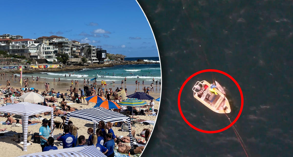
This news item is interesting, a drone operator finds a dead dolphin in one of the shark nets installed outside Bondi Beach to protect the surfers and swimmers there.
 au.news.yahoo.com
Now did this drone pilot, who shared his footage on his Instagram account, have some commercial license which allowed him to fly in the Bondi Beach area with few or no restrictions compared to recreational fliers?
Or does he not have any special license and nobody really questioned him because his footage is raising some notice which puts some public attention on these nets, because everyone is going to be sympathetic to dolphins being unintentionally killed by these nets?
Drone operator's 'devastating' discovery off Bondi Beach
Footage of the sad find has reignited calls for NSW to remove the deadly shark nets it sets off 51 of its popular beaches. Find out more.
Now did this drone pilot, who shared his footage on his Instagram account, have some commercial license which allowed him to fly in the Bondi Beach area with few or no restrictions compared to recreational fliers?
Or does he not have any special license and nobody really questioned him because his footage is raising some notice which puts some public attention on these nets, because everyone is going to be sympathetic to dolphins being unintentionally killed by these nets?
AnzacJack
Australian Defence Veteran
Plenty of flying permitted at bondi, however i think this bloke is operating commercially so no issue that i see
Hi all  ,
,
Newbie from Melbourne (Point Cook way) finally gave in to my desire and grabbed a M2P with Smart Controller (only 11 charges on the battery so practically new ) and heading out to start learning to fly (ripper of a day today so far
  ) love to fly with others if theres any around, dont know of any Drone "groups" if there are any... but would love to know if there are
Have a great weekend folks
,Newbie from Melbourne (Point Cook way) finally gave in to my desire and grabbed a M2P with Smart Controller (only 11 charges on the battery so practically new
) and heading out to start learning to fly (ripper of a day today so far ) love to fly with others if theres any around, dont know of any Drone "groups" if there are any... but would love to know if there are Have a great weekend folks
AnzacJack
Australian Defence Veteran
Similar threads
- Replies
- 7
- Views
- 960
- Replies
- 6
- Views
- 2K
- Replies
- 2
- Views
- 608
- Replies
- 4
- Views
- 1K
- Replies
- 40
- Views
- 19K


DJI Drone Deals
New Threads
-
Air 3 Cambuskenneth Abbey : Stirling
- Started by Coconut Island Drones
- Replies: 1
-
4 Pro Her Majesty, Mt. Dinara (Hrvatska) - True HDR10, 6K, 10-bit
- Started by Mountains
- Replies: 3
-
-
 3 Iskar reservoir in fog, ice and many birds
- Started by alex_markov
- Replies: 0
-

Members online
Total: 6,855 (members: 9, guests: 6,846)
Forum statistics
