DJI Mavic, Air and Mini Drones
Friendly, Helpful & Knowledgeable Community
Join Us Now

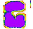
DJI Terra quality report excluding some ortho imagery

rtk350

New Member
Joined
Nov 17, 2025
Messages
2
Reactions
0
Age
35
Location
PG
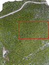
I recently did a flight to capture LiDAR data and RGB of a forested area, using the Matrice 350 RTK. We're running into a problem with the quality report generated by Terra. The LiDAR point cloud looks great, however the ortho preview as well as the scene overlapping visual show a significant missing chunk. Is there any way to tell what is causing the exclusion of this area?

TDOM Preview:
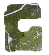
1763418013367.png
Scene Overlapping:
1763418043396.png
 
Is the area too homogeneous such as being just trees? The other areas have bald spots and roads which would work better with photogrammetry. I have had heavily forested areas not process on different occasions.

What was the flight height (GSD) and were you using nadir or oblique images?
 
Is the area too homogeneous such as being just trees? The other areas have bald spots and roads which would work better with photogrammetry. I have had heavily forested areas not process on different occasions.

What was the flight height (GSD) and were you using nadir or oblique images?
That's definitely possible. Here's an image of the missing chunk, which does look rather uniform. I am flying at 90m/300ft using nadir images

Screenshot.png
 
I have had this happen sometimes. But I am surprised that it happened at 300 ft since the larger FOV should allow each image to have more areas to match points in. Flying with all oblique images could help since they will have a larger FOV

Were you using RTK for the flights?
 

DJI Drone Deals

New Threads

Members online

Forum statistics

Threads
139,372
Messages
1,647,447
Members
167,618
Latest member
ameliazoe
Want to Remove this Ad? Simply login or create a free account