DJI Mavic, Air and Mini Drones
Friendly, Helpful & Knowledgeable Community
Join Us Now

DJI Terra quality report excluding some ortho imagery

rtk350

Member
Joined
Nov 17, 2025
Messages
5
Reactions
1
Age
35
Location
PG
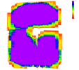
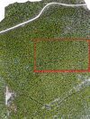
I recently did a flight to capture LiDAR data and RGB of a forested area, using the Matrice 350 RTK. We're running into a problem with the quality report generated by Terra. The LiDAR point cloud looks great, however the ortho preview as well as the scene overlapping visual show a significant missing chunk. Is there any way to tell what is causing the exclusion of this area?

TDOM Preview:
1763418013367.png
Scene Overlapping:
1763418043396.png
 
Is the area too homogeneous such as being just trees? The other areas have bald spots and roads which would work better with photogrammetry. I have had heavily forested areas not process on different occasions.

What was the flight height (GSD) and were you using nadir or oblique images?
 
Is the area too homogeneous such as being just trees? The other areas have bald spots and roads which would work better with photogrammetry. I have had heavily forested areas not process on different occasions.

What was the flight height (GSD) and were you using nadir or oblique images?
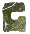
That's definitely possible. Here's an image of the missing chunk, which does look rather uniform. I am flying at 90m/300ft using nadir images

Screenshot.png
 
I have had this happen sometimes. But I am surprised that it happened at 300 ft since the larger FOV should allow each image to have more areas to match points in. Flying with all oblique images could help since they will have a larger FOV

Were you using RTK for the flights?
 
  • Like
Reactions: rtk350 and AMann
I have had this happen sometimes. But I am surprised that it happened at 300 ft since the larger FOV should allow each image to have more areas to match points in. Flying with all oblique images could help since they will have a larger FOV

Were you using RTK for the flights?
Good point, I would also suspect a temporary RTK dropout during that part of the flight.
 
  • Like
Reactions: rtk350
Good point, I would also suspect a temporary RTK dropout during that part of the flight.
I have had this happen sometimes. But I am surprised that it happened at 300 ft since the larger FOV should allow each image to have more areas to match points in. Flying with all oblique images could help since they will have a larger FOV

Were you using RTK for the flights?

Great point. I was using RTK, and it does drop on occasion. However, I would expect the LiDAR point cloud to also be affected in the same area in the case of an RTK drop. Is that the correct assumption to make? The LiDAR output did not show any issues in this area.
 
Great point. I was using RTK, and it does drop on occasion. However, I would expect the LiDAR point cloud to also be affected in the same area in the case of an RTK drop. Is that the correct assumption to make? The LiDAR output did not show any issues in this area.
I’m not familiar with your setup, does your LIDAR unit have its own integrated GPS unit?
 
You can go and view the RTK status for your flights.
Photo POS in Terra or turn on the drone and controller and look at the mission RTK report.

IMO it was the homogeneous trees and insufficient overlap. The default overlap works great for most areas, but forrest like that might need obliques or 90/90. Again, usually this happens when flying too low, but 300 ft AGL and above usually works.

Off subject, how did your L2 work in regards to producing a DTM? Good penetration to the bare ground?
 
  • Like
Reactions: AMann
You can go and view the RTK status for your flights.
Photo POS in Terra or turn on the drone and controller and look at the mission RTK report.

IMO it was the homogeneous trees and insufficient overlap. The default overlap works great for most areas, but forrest like that might need obliques or 90/90. Again, usually this happens when flying too low, but 300 ft AGL and above usually works.

I checked out the POS Status on the quality report generated by Terra - 100% fix. So you might be right in thinking it's insufficient overlap. We set the overlap to 80% - perhaps 90% is the better move?
Off subject, how did your L2 work in regards to producing a DTM? Good penetration to the bare ground?

It's been sufficient, although not ideal. We are mapping in a lot of high density coniferous stands so penetration is always a limiting factor.
 
  • Like
Reactions: jaja6009

DJI Drone Deals

New Threads

Members online

Forum statistics

Threads
139,401
Messages
1,647,830
Members
167,642
Latest member
ra banks
Want to Remove this Ad? Simply login or create a free account