DJI Mavic, Air and Mini Drones
Friendly, Helpful & Knowledgeable Community
Join Us Now

DJI Thermal Images Processing (converter to .tiff) SOLVED!

Thank you for this! Very helpful, and creates a beautiful orthomosaic, but unfortunately when I open it in ArcGIS it shows pixel DN instead of radiometric data...
Hi, this is unfortunate to hear, I'm not very practical with GIS softwares, I mainly produce outputs for 3d reconstruction .

Can you tell me more about the import problem in ArcGIS? It would be beneficial also for others if i can manage to fix it,
Thank you very much for your feedback anyway!
 
Thank you for this! Very helpful, and creates a beautiful orthomosaic, but unfortunately when I open it in ArcGIS it shows pixel DN instead of radiometric data...
Hi @xyzm,
I might have found one solution, but I'm not sure if you already tried.

When you export the orthomosaic, remember to check the "write alpha channel" as well, this will export the additional channel as float values.
I don't know if this is what you are looking for but it might help.

Let me know if you have suggestions!
 
Thanks for the tool Miro!

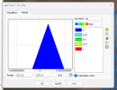
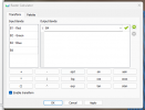
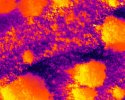
I try to use it with Mavic 3 T but it seems that the B4 value is not correct, i attach my settings in Metashape.

I also add one rjpeg.

Can you help me?

Thank you
 

Attachments

  • Screenshot 2024-01-31 115552.png
    Screenshot 2024-01-31 115552.png
    47.2 KB · Views: 11
  • Screenshot 2024-01-31 115915.png
    Screenshot 2024-01-31 115915.png
    32.4 KB · Views: 12
  • DJI_20240115153844_0001_T.JPG
    DJI_20240115153844_0001_T.JPG
    1.4 MB · Views: 12
Thanks for the tool Miro!

I try to use it with Mavic 3 T but it seems that the B4 value is not correct, i attach my settings in Metashape.

I also add one rjpeg.

Can you help me?

Thank you
Hi Mattia,
Can you tell me more about your issue?

- in metashape are you using the tiffs or the rjpeg?
- you need to use tiffs (if you want also visual rgb images , but then you need to select the multicamera system at the start)
- once you set B4, remember to hit apply before going to the palette page

If it is easier for you, contact me by email at [email protected], since you are from italy I can share you my number and we can message on whatsapp if you need
 
Thank you for your work sir, got one question, what version of metashape are you using? I dont get the same options when importing a folder.
Thanks
any version of metashape should work,
double check that your file/folder layout is one of the following cases:
  1. you are using both tiffs (converted with my tool) and WIDE rgb jpegs from the main drone camera
    • in this case both the tiffs and wide_Rgb.jpeg must be the same number, if they are in different number metashape wont recognise them as the same multisensor camera. if you are in this wrong case, discard the wide and use only the tiffs.
    • the Layout should be like this (import the main folder):
      • MAIN_FOLDER
        • RGB_WIDE_1.jpg
        • RGB_WIDE_2.jpg
        • RGB_WIDE_3.jpg
        • ......
        • ......
        • ......
        • THERMAL_FOLDER
          • Thermal_1.tiff
          • Thermal_2.tiff
          • Thermal_3.tiff
          • .....
          • .....
          • .....
  2. if you are using only tiff images, you wont see the option for multisensor camera, just use the single camera option and continue normally

Let me know if this helped, have a nice day!
Ill try it, do the names have to be RGB_WIDE_Number.JPG or any name_number.JPG will do?
 
Ill try it, do the names have to be RGB_WIDE_Number.JPG or any name_number.JPG will do?
They can be any name you like, usually I leave the name that came out of the dji camera, both for the thermal and the rgb ones, then you can give the main folder to my program and it will convert and replace all the thermal ones, and after open metashape and continue the procedure
 
Hi Miro, Grateful for you effort here. Would you happen to have a raster expression that transforms the radiometric data to absolute temperatures for the H20T?
 
Hi Miro, Grateful for you effort here. Would you happen to have a raster expression that transforms the radiometric data to absolute temperatures for the H20T?
Hi Charliepapadelta, I've converted many images from dji_radiometric (not the same as flir radiometric) to tiff with my tool, many of them were from H20T thermal cameras, can you elaborate a little bit more on what is your problem or what do you want to achieve? Do you mean a formula using my tool or maybe do you mean a formula for metashape?
I'll be happy to answer you!
Have a nice Day!
Hi Miro,
Thank you for the response. Yes I am using Metashape to create the orthomosaic from the .TIFF images created from your conversion tool. I am wondering if you have come up with an raster expression that will transform the radiometric data within the ortho to absolute temperature values. I found this one for a Sensefly platform, 0.01*thermal_ir - 100. I found this one for the XT-2, 0.04*thermal_ir - 273.15. Both will give you an index which is useful. I am wondering if there is a way to get the absolute temperature from the H20T? Here are the links to a couple of threads I am referencing.


Thank you for looking at this.

-Chuck
Hi, the converted images in TIFF format that come out of my tool are already in C° Celsius, inside metashape raster transform you can simply put the thermal channel as a formula, like B1 (if you are using only thermal images) or B4 (if you are using also rgb images).

This works for me quite well, let me know if you need help, if so I can send you my metashape workflow.
Hi, I found another thread where you explain this. I will just give B1 a try. Thank you.
 
We are trying to Create a program to find burning areas on large scale wildfire and would love some help.

I have two Questions.
  1. Is there a way to change the TIFF file to a FLIR ATLAS SDK compatible .jpg?
    1. We are having an issue with compatibility of newer DJI images (We based the Software off the Zenmuse XT) and need to convert files so they are readable.
  2. Anyone have Thermal Datasets? Ideally from a M30T or any other Drone types so we can work on our range of compatibility. The more the Merrier especially if there is a High temperature range of heat with in the files and they were collected in a gird style survey. High altitude flights also very welcomed!
 
Hey we have Software that currently Reads FLIR Atlas SDK (taken off a Zenmuse TX)

We are desperate to find a way to Convert The DJI M30T data into something a format our program can read. What are the chances you have something to help with that or know an avenue to help?

Hi Guys, I want to share my findings, here I made a simple tool with gui that let you convert any type of DJI thermal image into a Tiff image with one band containing temperature in celsius.

I made it using the DJI thermal SDK and python.

It is Hosted on my website and packaged as a self extracting .exe with 7zip,

I needed to package it because it needs part of the Dji sdk as dependency.

just download it, run(extract) where you want, and after extraction open the GUI that is the file called: "DJI Image Processor.exe"


View attachment 170976

It works with all dji models supported by the DJI Thermal SDK

This is the link: https://miro-rava.com/documents/DJI_Image_Processor.exe

Note: The section called"DJI Air 2 -Frame Extractor" was used for another purpose: (extracting geotagged frames from Air 2 videos giving as input a starting altitude)

contact me for the source code or any information!
 
We are trying to Create a program to find burning areas on large scale wildfire and would love some help.

I have two Questions.
  1. Is there a way to change the TIFF file to a FLIR ATLAS SDK compatible .jpg?
    1. We are having an issue with compatibility of newer DJI images (We based the Software off the Zenmuse XT) and need to convert files so they are readable.
  2. Anyone have Thermal Datasets? Ideally from a M30T or any other Drone types so we can work on our range of compatibility. The more the Merrier especially if there is a High temperature range of heat with in the files and they were collected in a gird style survey. High altitude flights also very welcomed!
Hi Danski_inthe_Sky, thanks for reaching out, Unfortunately i tried to add the functionality to convert images to FLIR Atlas SDK format but it is not working very well, maybe you can do the option in reverse, modify your software in order to make it accept tiff images, TIFF are an interchange format that is much more open and readable by many other softwares.

If you are interested i can take a look at your software that you are currently using for your zenmuse XT and maybe add compatibility for tiff files.

You can write me an email at [email protected] or write directly here!
Best Regards.
 
Hey we have Software that currently Reads FLIR Atlas SDK (taken off a Zenmuse TX)

We are desperate to find a way to Convert The DJI M30T data into something a format our program can read. What are the chances you have something to help with that or know an avenue to help?
Hi PFR, thanks for reaching out too!

I don't know if you are affiliated with Danski_inthe_Sky since your messages look very similar and you are both from canada, but as I said in their response, I tried to add the functionality to convert images to FLIR Atlas SDK format but it is not working very well, maybe you can do the option in reverse, modify your software in order to make it accept tiff images, TIFF are an interchange format that is much more open and readable by many other softwares.

If you are interested i can take a look at your software that you are currently using for your zenmuse XT and maybe add compatibility for tiff files.

You can write me an email at [email protected] or write directly here!
 
Thanks for sharing!
 
  • Like
Reactions: sarahb

DJI Drone Deals

New Threads

Forum statistics

Threads
135,150
Messages
1,603,010
Members
163,644
Latest member
mattyboyyeehaw
Want to Remove this Ad? Simply login or create a free account