


Felix...
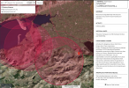
Thanks for all the assistance. I took your advice and entered one of the places I'd really like to film via drone: The Gap of Dunloe. I understand this is a large area, not just a single point. But it appears the entire area is red/NFZ. But it says in the description (see attachment) "Unless regulations in your region explicitly permit the operation of your drone in this area, we recommend you do not operate your drone here.
So, can I fly there or not, since not flying is a recommendation and not totally prohibited?
Side note: It's amazing how many "NFZ" areas there are in just that little screenshot area!

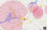
 you've got me there, Floyd. Interesting isn't it? This is starting to manifest more and more as the switchover from DJI proprietary geozones to the Euro GZM progresses. The only way it would make sense is if the yellow circle represented a geo-cage WITHIN the FRZ and I really can't see this being the case with airports and airfields.... but this is the EU we're talking about which means non-bureaucratic common sense went on holiday quite a few years ago.


