

When we fly during this time of the year, we are getting that our images are washed out, concrete and asphalt almost totally white. Is there a filter that would help with this problem and if so what one? We have a Mavic 2 pro and we fly for topography, so the camera on the drone is pointing straight down. Any help would be greatly appreciated.

You are using an out of date browser. It may not display this or other websites correctly.
You should upgrade or use an alternative browser.
You should upgrade or use an alternative browser.
Filter question
- Thread starter McCune Drone
- Start date
offtheback
Well-Known Member
- Joined
- Oct 3, 2017
- Messages
- 1,231
- Reactions
- 846
Except for maybe a polarizer set correctly for a little help,no filter should be needed om the M2P if the exposure can be set correctly.Any daytime scene can be properly exposed.If the asphalt is dominant and black it will mislead your camera and overexpose and make the asphalt come out middle gray and the concrete near white.Try 5 stop bracketing in the settings and see what happens.If you point a camera at a blank wall of any color light or dark it will try to make the wall come out middle tone.When we fly during this time of the year, we are getting that our images are washed out, concrete and asphalt almost totally white. Is there a filter that would help with this problem and if so what one? We have a Mavic 2 pro and we fly for topography, so the camera on the drone is pointing straight down. Any help would be greatly appreciated.

- Joined
- May 25, 2017
- Messages
- 8,476
- Reactions
- 7,966
- Age
- 63
Yes, your problem is overexposure, or auto exposure compensating for black / dark bitumen (asphalt) vs white concrete type of opposites.
Filters are of no use except a PL if it's more reflective, like off wet surfaces, then a PL might help.
It's probably more likely to be simple exposure settings, maybe try manual exposure setting, the M2 has the great ability to adjust aperture and shutter speed, make sure iso is on 100 for normal outdoor use.
A couple of Go4 tools that may help are the histogram and overexposure warning . . .
Both explained in the manual or Go4 manual, or some great tutorials on Youtube, search there for Mavic 2 pro histogram / overexposure warning / bracketing . . . etc type of keywords.
The solution is to find the cause of the issue.Thank you all. We are still working to try to figure this out. I really appreciate the help.
If you post one of your full-size original jpg images, that will have metadata to show the settings used and how to fix the issue.
I'll have to pull the metadata on those, I'll try to get that tomorrow, thanks for all the responses and help.
If you just post one of the images here, I can look at it straight away.I'll have to pull the metadata on those, I'll try to get that tomorrow, thanks for all the responses and help.
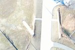
The reason the pix are overexposed is that you've got the exposure compensation set to +2.0.Here is one.
That's adjusting the exposure settings to 2 stops more than the camera's metering thinks would be correct.
Look for the line of camera data on your screen and notice under EV, it's showing +2.0.
You need to dial that back to 0 or even -0.3 and your exposure will be fine.

Every image recorded by the DJI cameras (and most other digital cameras) contains metadata in the digital file.How do you find the metadata on the posted picture?
You can read it with lots of software
offtheback
Well-Known Member
- Joined
- Oct 3, 2017
- Messages
- 1,231
- Reactions
- 846
Thanks.I did download it to Apple Photos and found the metadata there.A question:The DNG file from an M2P file is about 40 MB while the ORF/Raw from an Olympus 4/3 sensor is 18-20 MB.The 4/3 sensor is of course larger and the MPX count is the same at 20 so why would the M2P file be double the size?Every image recorded by the DJI cameras (and most other digital cameras) contains metadata in the digital file.
You can read it with lots of software
Thanks I really appreciate the help. Can you tell me more about that software?Every image recorded by the DJI cameras (and most other digital cameras) contains metadata in the digital file.
You can read it with lots of software
Photoshop and other image processing software will show you the basics and some others will show all the metadata.Thanks I really appreciate the help. Can you tell me more about that software?
Google Exif viewer and you'll see a selection of alternatives.
Good question ... I don't know the answer.
Irfanview is a great photo and video viewer/basic editor that can display the EXIF information. It's free from irfanview.com. PC only, no IOS version. I've used it for years.Photoshop and other image processing software will show you the basics and some others will show all the metadata.
Google Exif viewer and you'll see a selection of alternatives.
Believe it or not I use infraview on a daily basis and have for years also. Didn't know that it could give me that information.
I'm an civil/land/survey drafter. My wife and I decided to expand our business got into the drone work.
I'm an civil/land/survey drafter. My wife and I decided to expand our business got into the drone work.
Click Image | Info from the top menu and then look for the EXIF Info button.Believe it or not I use infraview on a daily basis and have for years also. Didn't know that it could give me that information.
I'm an civil/land/survey drafter. My wife and I decided to expand our business got into the drone work.
What sort of drone work are you doing?
Thanks I really appreciate the help. Can you tell me more about that software?
Some of the basic data doesn't need anything special, I downloaded your photo to my desktop and then: right click > Properties > Details Tab and can see the following:

Thanks.Some of the basic data doesn't need anything special, I downloaded your photo to my desktop and then: right click > Properties > Details Tab and can see the following:
View attachment 145140
Similar threads
- Replies
- 6
- Views
- 772
- Replies
- 0
- Views
- 387
- Replies
- 3
- Views
- 589
- Replies
- 6
- Views
- 472


DJI Drone Deals
New Threads
-
 DJI Geo Fencing Sneaking Back In Via Firmware "Update". Beware!
- Started by Conservative Nihilist
- Replies: 2
-
-

-
 2 Genuine DJI Mini 4 Pro, Mini 3 Series Plus Intelligent Flight Battery
- Started by Dogpilot
- Replies: 0
-

Forum statistics
