I'm sorry if I'm on the wrong forum page I see 2 references to my post about the sub-forum which I cannot view but as if I should be posting somewhere else, if so set me straight.
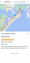
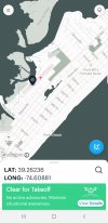
One reason I bring this question up is I have had several inputs towards which answer is right and correct and If the FAA wants to control it then maybe we should get all our Drone authorization maps on the same page, right now they are all over the place as far as consistency. I know we are not talking about a LAANC clearance but even if we legally don't need a clearance the supporting app"s and programs should be standardized so we have standard symbols for each. For what responses I have received there is no consistency and this is what I have been observing consistently and before I posted about OCNJ. Here is what the 5 I have used or looked at show for OCNJ
1. B4UFLY is the most general of them all it shows green and no warnings or area to be concerned with.
It has always showed the most lenient and low information of them all and to sometimes not correct even in areas
where there should have been a LAANC.
2. ALOFT this the next it shows clear airspace no warnings for OCNJ Green It does show the medical center and
municipal airport.
3. UAsidekick this show green go fly only showing the airport and the hospital no other info
4, DJI APP shows the airport and the hospital plus other general map items. no warnings
5. Airmap has the triangle AMBER this is the only one that list schools. 2 schools,1 heliport the hospital and 3 small
airfields which one of them really isn't the hospital Somers Point. These are all listed as advisories.
6. the last is Fly App which I do not have but someone showed on the thread it shows the schools and the Municipal
airport but no hospitals. It has quite a long and narrow rectangle over an enlarged area where for general airport
the aircraft taking off and landing at the airport should not be below 400 feet anyway other then close in for landing and takeoff.
If I am on the beach just south of the pier and I'm flying at 100ft or lets say the max under 400" then which is more of a hazard. me at 300 feet over the beach not close to the airport or a Cessna 172 at 400feet over the beach not the water. There minimum altitude is 500ft VFR. I would be more concerned about an aircraft over the sand at 400 feet then the drone.
My point is each one of these flying apps were to use to go along with the FAA is inconsistent, which opens up discussion like this. I don't want anymore restrictions but those which are supposedly in place should be standardized
across the board. As far as listing the airport yes for awareness but I'm not to be over people or houses anyway.
So this would consider the schools and hospitals. Yes the hospitals are shown to give a heads up to the medivacs
which can be at any altitudes, so lets show them on all app's.
Ok enough. Again thanks for your input.
Sterk03


