DJI Mavic, Air and Mini Drones
Friendly, Helpful & Knowledgeable Community
Join Us Now

Flying in America?

agour

Well-Known Member
Joined
Nov 22, 2016
Messages
45
Reactions
9
Age
34
Hello!

I'm off to California next week, and wondered what the legalities are for flying a drone there as a hobbyist?

I'm struggling to find the right info, I found something about requiring registration, but haven't found a clear cut website yet.

Thanks!
-agour
 
Before flying as a hobbyist in the US, you must register with the FAA here and attach your registration number to your Mavic.
 
Before flying as a hobbyist in the US, you must register with the FAA here and attach your registration number to your Mavic.
awesome, thank you!

After that, does the usual rules apply (dont fly over 500ft, keep line of sight, etc)?

Also, was the ban ever lifted on flying in national parks?
 
awesome, thank you!

After that, does the usual rules apply (dont fly over 500ft, keep line of sight, etc)?

Also, was the ban ever lifted on flying in national parks?

It's 400 feet above ground level. Not sure about the ban on national parks, but most of them are restricted airspace to begin with so you have to follow that as well. There is a great app called B4UFly by the FAA that tells you if your good to fly or not.
 
  • Like
Reactions: r4nd0m
"On June 19, 2014, National Park Service Director Jonathon B. Jarvis signed Policy Memorandum 14–05, Unmanned Aircraft – Interim Policy. Its purpose was “to ensure that the use of unmanned aircraft is addressed in a consistent manner by the NPS before a significant level of such use occurs within the National Park System.” Each superintendent was directed “to use the authority under 36 CFR 1.5 to close units of the National Park System to launching, landing, or operating unmanned aircraft…” This policy is still in place and the public may not use unmanned aircraft in the national parks."

Aviation: Unmanned Aerial Systems | U.S. National Park Service
 
  • Like
Reactions: Bill Debevc
It's 400 feet above ground level. Not sure about the ban on national parks, but most of them are restricted airspace to begin with so you have to follow that as well. There is a great app called B4UFly by the FAA that tells you if your good to fly or not.

I work as a commercial pilot, and I got that app, hoping to do the right thing. The problem is, that app shows a lot of private airports that are long since defunct. One in my area has twenty foot trees growing where the runway used to be.
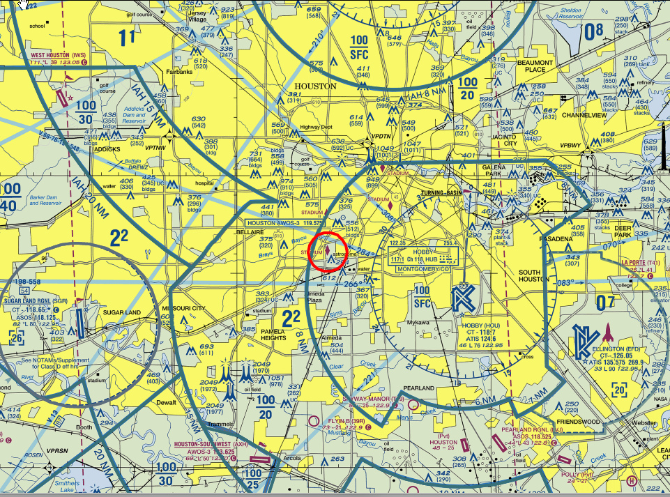
I know this is difficult for most people to get, but a better resource is a recent sectional for your area, which is a chart pilots use in good weather, and shows all active airports, both private and public. It also shows the airspace associated with those airports.

The problem is, sectionals can be difficult to get, and they aren't cheap. A good FBO, or Fixed Base Operation, will have them. These are at some, but not all airports. Alternatively, some apps used by GA pilots have them. Haven't researched this, maybe somebody will chime in.
 
I just registered directly through the FAA website as a Canadian citizen for 5 bucks. Unlimited drones in my possession fall under this registration and is good for 3 years. Quick and easy with an immediate email from the FAA giving me a number which must be visible on all drones that need to be registered, as well as a registration certificate.
 
  • Like
Reactions: David_Paz
In the U.S., it is not currently legal to take-off or land in a National Park. The FAA controls all airspace in the U.S., so the Park Service cannot prevent flying over a National Park (technically) but can prevent take-offs and landings. So, legally, if you take-off and land outside of the park you are legal to fly over the park (assuming it's not otherwise restricted airspace). But, good luck convincing the park rangers of this nuance in U.S. law. I'm guessing they will try to stop you anyway.

The bottom line is that the Park Service does not want UAVs in National Parks. It is really unfortunate but it's reality.


Sent from my iPad using MavicPilots
 
Of I remember correctly this may differ from state to state though - I always register with the AMA every time I go being registered to the BMFA but even as an AMA temporary member there were restrictions - worth reaching out to any local modelling clubs to get the latest requirements - had to pay a big fine (>3000$) probably 4 years ago as the rules I was told didnt apply in that state .. hence worth checking on a per state basis
 
I work as a commercial pilot, and I got that app, hoping to do the right thing. The problem is, that app shows a lot of private airports that are long since defunct. One in my area has twenty foot trees growing where the runway used to be.
I know this is difficult for most people to get, but a better resource is a recent sectional for your area, which is a chart pilots use in good weather, and shows all active airports, both private and public. It also shows the airspace associated with those airports.

The problem is, sectionals can be difficult to get, and they aren't cheap. A good FBO, or Fixed Base Operation, will have them. These are at some, but not all airports. Alternatively, some apps used by GA pilots have them. Haven't researched this, maybe somebody will chime in.

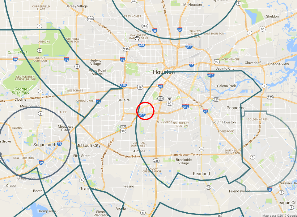
I use Aviation Charts on Google Maps | iFlightPlanner which not only has free sectionals, but also the ability to show different class airspace boundaries overlaid on google maps, which is great.
Using sectionals alone it's hard to determine if the particular spot you have chosen to fly is in controlled airspace because sectionals are just not that detailed when it comes to showing roads & streets, and they don't show satellite imagery.
 
  • Like
Reactions: cobra46
How do you get it to overlay? Looks to me like it's one or the other, and the sectionals and TACs don't zoom in to the level required.
Click on Map or Satellite view, then click on the icon in the upper right that looks like 3 sheets of papers, the layers control icon, then put a check mark in the boxes next to any of the airspace classes that you want to see on the map, then click Done.
You'll have to switch back to the Sectional view to see the altitude of the bottom/floor of each of the airspace zones.
 
Last edited:
  • Like
Reactions: joet
Ah; very nice, thanks!

The only thing I wish is that you could display only that airspace that extends to the surface.

I found some similar plots for Google Earth, and with a bit of work managed to eliminate the non-surface areas and import that into Google Maps. The major issue there is that the source does not have Class E airspace included.. So I still have to check the sectionals to ensure there's no SFC Class E around. Unfortunately, it appears that here in the Tampa area, the areas it thinks are Class E are really Class D. Oh well, they do say that it's beta. :)
 
Last edited:
Ah; very nice, thanks!

The only thing I wish is that you could display only that airspace that extends to the surface.

I found some similar plots for Google Earth, and with a bit of work managed to eliminate the non-surface areas and import that into Google Maps. The major issue there is that the source does not have Class E airspace included.. So I still have to check the sectionals to ensure there's no SFC Class E around. Unfortunately, it appears that here in the Tampa area, the areas it thinks are Class E are really Class D. Oh well, they do say that it's beta. :)

FYI some class D airspace switches to class E when the tower is not in operation. Maybe that's what is confusing it?


Sent from my iPhone using MavicPilots
 
I just registered directly through the FAA website as a Canadian citizen for 5 bucks. Unlimited drones in my possession fall under this registration and is good for 3 years. Quick and easy with an immediate email from the FAA giving me a number which must be visible on all drones that need to be registered, as well as a registration certificate.
From my understanding, the registration number does not need to be visible but needs to be accessible. If I'm not mistaken, I thought it was even mentioned on the FAA website that you can place the number onsite the battery compartment. Can someone confirm this, I can't seem to locate where I read this.
 
From my understanding, the registration number does not need to be visible but needs to be accessible. If I'm not mistaken, I thought it was even mentioned on the FAA website that you can place the number onsite the battery compartment. Can someone confirm this, I can't seem to locate where I read this.

"The number may also be enclosed in a compartment that is readily accessible, such as a battery compartment."
It's in a number of places. I quoted from the FAA's frequently asked questions, "Registration," paragraph 8.

Unmanned Aircraft Systems (UAS) Frequently Asked Questions/Help
 

DJI Drone Deals

New Threads

Forum statistics

Threads
130,601
Messages
1,554,306
Members
159,608
Latest member
carlos22