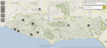
Oh yes, the NP covers everything around Malibu. B4UFLY has the complete area swathed in red. But I would like to know where the "exact" boundaries are, particularly when you go south, to the ocean, south of PCH:
View attachment 152999
There is also this:
City of Malibu – Filming Permit
In order to operate a drone for commercial purposes, drone operators must obtain a filming permit with the city. Most of the Malibu airspace is under National Park airspace which is a No-Fly Zone. However, the city can issue permits for commercial drone operations such as taking real estate pictures. Information regarding the permits and application process can be found
here.
Which is technically incorrect, as the NP is a no take off/land zone, not a no fly. They have no control over the actual airspace, other than staying away from wildlife, wilderness areas, etc.
But I'm not looking for commercial purposes, just some fabulous coastline shots.


