You can do it in the GO4 app, provided the drone supports waypoints 2.0. However, it's a right faff and I prefer to use Litchi - much simpler, and works better.
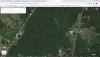
With Litchi, you plan the path on your PC. Litchi uses Google maps so you get both the map view and aerial view. All you have to do is log onto the Litchi app on the phone / tablet you use to fly the drone (internet is required) and download the saved route and hit go.
You can go a step further and use Virtual Litchi Machine (PC only). In Litchi, export your path as .csv and open it in virtual Litchi, it will then do some converty-type-stuff, automatically open Google earth and you can then check your path for obstacles in 3d (trees grow and things get built after the Google scans) and even fly a virtual flight to see how the footage will look so that you can make adjustments. There are plenty of tutorials on Youtube.
The only thing to say is if the drone is the
Air 2 (maybe the Mini - not sure on that one) DJI have yet to release the SDK to allow Litchi to add that drone, so it works with the
Mavic 2 range and the original Air. Just check your drone is supported before purchase as things change.
The PC parts of this are free so you can have a play with it. You do need to pay for the app to fly the drone though. Android and Apple both supported and work brilliantly.