I have been using Google Earth Pro (with terrain on, checked) to plan some of my Litchi missions. Recently I noticed that in some areas the terrain data no longer works for me, Please check out this test and see if you have the same problem. If so, can you explain what I can do about it.
Here is an example:
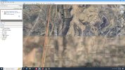
Bring up Google Earth Pro on a windows PC
Make sure the terrain layer is on (checked)
Search for "New River School, Az." (This has nothing to do with the school)
Does the area below the school look very fuzzy to you? This fuzzy area is very large (many miles!)
Missions that I planned several months ago, in these fuzzy areas, now fly underground when analyzed.
If you confirm this, can you suggest how to fix this problem or is this a Google problem, or a National security problem?
Again I am using Google Earth Pro to plan way-point missions in these areas.
Thank you,
Here is an example:
Bring up Google Earth Pro on a windows PC
Make sure the terrain layer is on (checked)
Search for "New River School, Az." (This has nothing to do with the school)
Does the area below the school look very fuzzy to you? This fuzzy area is very large (many miles!)
Missions that I planned several months ago, in these fuzzy areas, now fly underground when analyzed.
If you confirm this, can you suggest how to fix this problem or is this a Google problem, or a National security problem?
Again I am using Google Earth Pro to plan way-point missions in these areas.
Thank you,