DJI Mavic, Air and Mini Drones
Friendly, Helpful & Knowledgeable Community
Join Us Now

GRID tool for Litchi

PanX

Well-Known Member
Joined
Apr 25, 2020
Messages
86
Reactions
51
Age
57
Location
Athens, Greece
I made a small app (for Android) to make Grids for Litchi. After you make the csv file (ENTER) you can email it to yourself and open it with MISSION HUB.
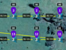
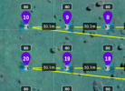
I believe this is the final version. Please gnore the error when you open map for first time. It will not show again (its an initialization file).
I think, in conjuction with Hub's MOVE and ROTATE tools (and Heading options in mission's settings) someone can do any 3d job in one or more fligths.
Always check your WP's dont fly blind. Its a BETA version and it will remain as such.
Enjoy.

mm1.jpgmm2.jpgmm3.jpg
 

Attachments

  • LITCHIGRID_BETA_51.zip
    3.5 MB · Views: 68
This is great! I use the following two formulas in a spreadsheet to get the same result, but this is much quicker! I have about twenty pre-made grids that I use and just change with the MOVE and ROTATE functions as I need.

=2 * 6371000 * ASIN(SQRT((SIN((C2*(3.14159/180)-A2*(3.14159/180))/2))^2+COS(C2*(3.14159/180))*COS(A2*(3.14159/180))*SIN(((D2*(3.14159/180)-B2*(3.14159/180))/2))^2))

=6371*ACOS(COS(RADIANS(90-D7))*COS(RADIANS(90-D8))+SIN(RADIANS(90-D7))*SIN(RADIANS(90-D8))*COS(RADIANS(E7-E8)))*1000

Great work!
 
  • Like
Reactions: PanX
This is great! I use the following two formulas in a spreadsheet to get the same result, but this is much quicker! I have about twenty pre-made grids that I use and just change with the MOVE and ROTATE functions as I need.

=2 * 6371000 * ASIN(SQRT((SIN((C2*(3.14159/180)-A2*(3.14159/180))/2))^2+COS(C2*(3.14159/180))*COS(A2*(3.14159/180))*SIN(((D2*(3.14159/180)-B2*(3.14159/180))/2))^2))

=6371*ACOS(COS(RADIANS(90-D7))*COS(RADIANS(90-D8))+SIN(RADIANS(90-D7))*SIN(RADIANS(90-D8))*COS(RADIANS(E7-E8)))*1000

Great work!
Thank you. i also use the earth's mean radius but.. i am not sure it has any effect in such small distances taking in consideration that drone flys in level line.
 
I can use the formulas to create a complete mission with just a spreadsheet; no Litchi or Google Earth or internet necessary. I can choose to put a point wherever I want with around ten centimetres accuracy. I just need the starting GPS position and then plug in the formula for whatever distance I want. It is time consuming and brain taxing but it was the only way, until now, that I could make an accurate grid type pattern.

When I make my mapping grid, I fly, say, ten waypoints at 50 metres each, then I fly to a point that is 50 metres South of point 1, then I fly another ten waypoints parallel to the first set, then repeat. I'll post a screenshot as an example. Would it be possible for you to tweak your app to give out the same results? I have found that my stitching software works much better if all the pictures are taken from the same perspective and the drone has issues with going backwards with the camera pointed straight down.

If you can't, it's no biggy. I can re-number the waypoints in the .csv file.
 

Attachments

  • 3.png
    3.png
    54.1 KB · Views: 10
  • 2.png
    2.png
    56.4 KB · Views: 10
  • 1.png
    1.png
    729.1 KB · Views: 11
  • Like
Reactions: PanX
I can use the formulas to create a complete mission with just a spreadsheet; no Litchi or Google Earth or internet necessary. I can choose to put a point wherever I want with around ten centimetres accuracy. I just need the starting GPS position and then plug in the formula for whatever distance I want. It is time consuming and brain taxing but it was the only way, until now, that I could make an accurate grid type pattern.

When I make my mapping grid, I fly, say, ten waypoints at 50 metres each, then I fly to a point that is 50 metres South of point 1, then I fly another ten waypoints parallel to the first set, then repeat. I'll post a screenshot as an example. Would it be possible for you to tweak your app to give out the same results? I have found that my stitching software works much better if all the pictures are taken from the same perspective and the drone has issues with going backwards with the camera pointed straight down.

If you can't, it's no biggy. I can re-number the waypoints in the .csv file.
This is the "easy" senario... the hard thinking was the opossite, to find a way with 2-3 lines to reverse the route like the final Zig-zag in order to not spare flight time and battery on not productive fly. If you choose "AUTO (TNW)" on mission settings, drone will fly always forward heading to the next point, so there is not a problem to solve. Generally "Heading" settings in Mission Hub (with a little thougth) allow us for all senarios of flights regarding heading of the drone

Thanks a lot for all your attention and nice words.
 
Last edited:
  • Like
Reactions: Dronut
I can use the formulas to create a complete mission with just a spreadsheet; no Litchi or Google Earth or internet necessary. I can choose to put a point wherever I want with around ten centimetres accuracy. I just need the starting GPS position and then plug in the formula for whatever distance I want. It is time consuming and brain taxing but it was the only way, until now, that I could make an accurate grid type pattern.

When I make my mapping grid, I fly, say, ten waypoints at 50 metres each, then I fly to a point that is 50 metres South of point 1, then I fly another ten waypoints parallel to the first set, then repeat. I'll post a screenshot as an example. Would it be possible for you to tweak your app to give out the same results? I have found that my stitching software works much better if all the pictures are taken from the same perspective and the drone has issues with going backwards with the camera pointed straight down.

If you can't, it's no biggy. I can re-number the waypoints in the .csv file.
Attached is the file with the new version in which you can choose the type of the grid according to your schema. After a while i understand that i was wrong and you really need it if you use non-mapping oriented platform to stich the pictures like photoshop etc. Yes that way stiching is problematic because half of the pictures are "upside down". drone1.JPGdrone2.jpg
 

Attachments

  • LITCHIGRID_BETA_6.zip
    3.5 MB · Views: 46
  • Like
Reactions: AMann and Dronut
Thank you very much for your work! Your new version works as great as the first one.

I use Linux, so my offline options for orthomosaics aren't great. I use Hugin, which is great for panorama stitching but sometimes not so great for mapping, and I use an Android app called Mapstitch, which does amazing work on my phone, but it takes a long time to do its stuff.

Your app saves me a great amount of time and I can directly choose the photo overlap now, instead of using trigonometry! Thanks again! :)
 
  • Like
Reactions: AMann and PanX
A am interested in using this tool but am unfamiliar with how to build an app from an apk file. I have unzipped and downloaded the apk file to my android tablet but don't know what to do with it after that. Internet just seems to want to talk about how to create the apk from the app, not the other way around. Any guidance would be helpful. Also, is beta 6 your latest? Thanks
 
A am interested in using this tool but am unfamiliar with how to build an app from an apk file. I have unzipped and downloaded the apk file to my android tablet but don't know what to do with it after that. Internet just seems to want to talk about how to create the apk from the app, not the other way around. Any guidance would be helpful. Also, is beta 6 your latest? Thanks
You should just have to go to the folder where you downloaded the APK and just click on it. You might need to change some permission settings to allow your file manager to install the app.
 
Lycus Tech Mavic Air 3 Case

DJI Drone Deals

New Threads

Forum statistics

Threads
130,984
Messages
1,558,573
Members
159,977
Latest member
JTBennett00