DJI Mavic, Air and Mini Drones
Friendly, Helpful & Knowledgeable Community
Join Us Now

Height limitation flying over water

Jman13

Active Member
Joined
Aug 18, 2022
Messages
41
Reactions
139
Age
46
Location
Columbus, OH, USA
Site
www.jsteelephotos.com
So today I was flying my Air 2S over the Scioto River for some shots of Columbus, and the wind and water were exceptionally calm (1-2mph winds). At some points, I was around 10 feet over the water, then I flew higher for a while. I was trying to get a specific shot with a bridge framing the city, and tried to lower the drone to get the correct angle. However, at that point, it would not let me get any lower than 33 feet above the water. I didn't want to press down much harder because I didn't want it to think I was trying to land the drone on the river...but it was weird.

Is this the obstacle avoidance getting confused by the reflection of the water? I assume I would have been able to go lower if I turned off obstacle avoidance, but since I'm a new pilot, I didn't want to push it. I had no problems landing the drone manually once I pulled it back over land. Anyone else experienced this?
 
  • Like
Reactions: a2tomm and Gagey52
quite likely re: the confusion. the manual even discusses this and you were smart not to push it. many folks have lost their drones because of this kind of thing.
 
However, at that point, it would not let me get any lower than 33 feet above the water. I didn't want to press down much harder because I didn't want it to think I was trying to land the drone on the river...but it was weird.

Is this the obstacle avoidance getting confused by the reflection of the water?
Drone flyers are a lot more confused about flying over water than DJI drones ever are.
What you've described sounds unusual.
You shouldn't have any minimum height limit over water, just like you don't over land.

Perhaps your recorded flight data would have some clues to explain the issue.

Go to DJI Flight Log Viewer | Phantom Help
Follow the instructions there to upload your flight record from your phone or tablet.
That will give you a detailed report of the flight.
Come back and post a link to the report it gives you.
Or .. just post the txt file here.
 
  • Like
Reactions: Smooth Rhythm
Here's the time I was talking about. It was 36 feet I guess. Anyway, you can see I began pressing down on the right stick (I fly Mode 3, so that's my elevation), and no elevation change at all. No messages. Then I swapped and brought the drone up. Looking at the full data (CSV) I don't see anything unusual, but I'm not exactly super experienced at looking at these (though as an engineer I'm familiar with sorting through data)


pertinent_log.jpg
 
The VPS sensor will only work when you are close enough to ground for sensors to determine altitude. Once you got over water you were higher over the water and the water was not correct reflective surface to determine altitude;--one of dangers of flying over water. VPS sensors kicked in when you were back over land.
Why it wouldn't descend more over water, I don't see a clue.
 
  • Like
Reactions: rjwmorrell
What was the surface condition of the water? How much sun shining on the water?
 
Yeah, I did another flight this afternoon, and can confirm that the VPS works fine over land, then shuts off immediately when it gets over water, and at high altitudes. After shutting off, it seems to turn back on over land at an altitude of about 30 feet.
 
Indeed very calm. Here's a shot from when I was a bit further out and much higher, but you can see conditions. The situation in question happened at a location between these two bridges, closer to the arched bridge, but not in the bridge shadow.

cbus_aerial_lnorth.jpg
 
  • Like
Reactions: MavicFlyer2
Interesting observations about the bridge shadow where the sun isn't refecting.
From the looks of the water its like trying to measure reflective height from a mirror; it doesn't work. I've seen where the VPS number stays locked in when the altitude is too high over land; in your case it goes blank and I suspect it's the reflective surface which confuses the sensor.
My guess is somewhere there a fail-safe descent level when VPS sensors get "lost". I never saw and adjustment option for my Air 2s.
 
Does it apply here to turn off obstacle avoidance? This was a standard practice when flying over water with my Phantom4 as the reflection from the surface would confuse the sensors.
 
Does it apply here to turn off obstacle avoidance? This was a standard practice when flying over water with my Phantom4 as the reflection from the surface would confuse the sensors.
You cannot turn off the downward facing sensors of any drone that uses DJI Fly.
Obstacle avoidance is completely separate.
 
Interesting observations. When it first lost total VPS reference the ATL altitude was 30 feet. The VPS is a vertical positioning reference and the reflection confused the VPS system so that it has no clue about vertical positioning. Therefore a failsafe minimum altitude is established as 30 feet ATL. The drone knows that it is safe to descend to that level but no more as the VPS isn't working over the mirror. When over land VPS can sense something, even if not precise over something like 60 feet, but the mirror below is a vertical positioning error or confusion so the last safe altitude becomes failsafe.
You could test this be ascending to 60 feet ATL and flying over the mirror to see if the minimum descent altitude now becomes 60 feet, the last recorded VPS position.
 
So today I was flying my Air 2S over the Scioto River for some shots of Columbus, and the wind and water were exceptionally calm (1-2mph winds). At some points, I was around 10 feet over the water, then I flew higher for a while. I was trying to get a specific shot with a bridge framing the city, and tried to lower the drone to get the correct angle. However, at that point, it would not let me get any lower than 33 feet above the water. I didn't want to press down much harder because I didn't want it to think I was trying to land the drone on the river...but it was weird.

Is this the obstacle avoidance getting confused by the reflection of the water? I assume I would have been able to go lower if I turned off obstacle avoidance, but since I'm a new pilot, I didn't want to push it. I had no problems landing the drone manually once I pulled it back over land. Anyone else experienced this?
Maybe that moment someone was looking over your shoulder,count your blessings ,Air 2s knows things
 
Interesting observations. When it first lost total VPS reference the ATL altitude was 30 feet. The VPS is a vertical positioning reference and the reflection confused the VPS system so that it has no clue about vertical positioning. Therefore a failsafe minimum altitude is established as 30 feet ATL. The drone knows that it is safe to descend to that level but no more as the VPS isn't working over the mirror. When over land VPS can sense something, even if not precise over something like 60 feet, but the mirror below is a vertical positioning error or confusion so the last safe altitude becomes failsafe.
You could test this be ascending to 60 feet ATL and flying over the mirror to see if the minimum descent altitude now becomes 60 feet, the last recorded VPS position.
Huh??

VPS is not used for vertical positioning. The barometric altimeter does that. You can see that quite clearly in the Phantomhelp log viewer. Look at the IMU Altitude numbers compared to the VPS Altitude starting from the moment of takeoff at the Home Position.

The drone first takes off and climbs straight up to 26.9ft, with both the IMU and VPS altitudes closely agreeing. Then the drone starts moving toward the river at a constant height with no up-throttle applied until about 2m 14s. That entire time the IMU Altitude controlled by the barometric altimeter (height above take off location) stays constant between 29.9-30.2ft.

But look at the VPS Altitude over that same time period, starting from when the drone first started to move forward toward the river. The VPS Altitude is the actual height above ground measured by the bottom infrared sensor. It agrees closely with the IMU barometric sensor as the drone rises straight up from its takeoff location. But the moment the drone starts moving forward, the VPS sensor displays different heights depending on what it "sees" passing below the drone.

The ground slopes downhill toward the river. So the VPS Altitude shows an increasing height above ground, as the IMU barometric altitude stays constant at ~30ft. At 21s the VPS altitude suddenly shows only an 18.7ft clearance as the drone passes over that tree. At 1min 10.9s the drone is already over the water, still showing a steady ~30ft barometric altitude, whereas the VPS altitude is now 44.9ft. At that point the VPS infrared height sensor loses contact with the water's surface, either because it's just too high and out of range or the infrared signal is being absorbed by the water and not reflected back to the sensor. But it tells us the takeoff location was 14.9ft higher than the water's surface.

The VPS sensor never determines or limits a safe minimum descent altitude, except during landing. If the VPS height sensor is functioning and sensing close proximity to the ground (something like 2ft) it will prevent the drone from sinking any lower unless you confirm you actually want it to land by holding the throttle stick full down.

If you're at a height of 30ft, or 60ft, or more, the only way the VPS height sensor might prevent the drone from descending is if it detects something like thick fog (or a treetop) in close proximity below the drone, fooling it into believing it's hovering within 2ft of the ground. But in that case, you can still force it to descend by holding the throttle stick full down to trigger auto-landing and it will then descend to land (which you can cancel whenever you want).
 
  • Like
Reactions: Meta4
Here's the time I was talking about. It was 36 feet I guess. Anyway, you can see I began pressing down on the right stick (I fly Mode 3, so that's my elevation), and no elevation change at all. No messages. Then I swapped and brought the drone up. Looking at the full data (CSV) I don't see anything unusual, but I'm not exactly super experienced at looking at these (though as an engineer I'm familiar with sorting through data)


View attachment 153556
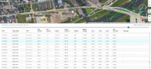
In your image from the Phantomhelp log viewer, at 15m 22.6s you have the throttle held full down, and 22.7s, 22.8.s, 22.9s. But then the data suddenly skips two seconds to 24.9s where the throttle is held full up.

What happened during those missing two seconds?

Is it possible that the bridge was blocking your control signal? According to the Air 2S user manual, Failsafe RTH only kicks in after 6 seconds of signal loss.

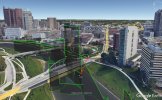
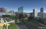
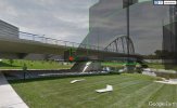
Using Google Earth to plot your flight path, it does look like the bridge is directly between the drone and your takeoff location at that moment.

GoogleEarth1.jpg

GoogleEarth2.jpg

GoogleEarth3.jpg
 
It is possible, but I don't think likely. I did go down to the water to be able to keep eyes on, but there were small gaps of course.

In those two seconds, I tried to get it to descend, didn't want to initiate a landing, and then went back up.

I do show 100% signal in my logs, and it did go back up as soon as I wanted. I also moved backwards and attempted to go down again without success and it responded well to that.

As an aside, I did some night shooting later, and had no problems getting the framing I was after, though it also turns off any collision avoidance in the dark.
 
According to the Air 2s manual (page16) the Downward Vision System and Infrared Sensing System helps the aircraft maintain its current position [that would be vertical positioning].
Page 18 gives various conditions when the vision system may not work as expected.
 
According to the Air 2s manual (page16) the Downward Vision System and Infrared Sensing System helps the aircraft maintain its current position [that would be vertical positioning].
The manual says:
The Downward Vision System and Infrared Sensing System helps the aircraft maintain its current
position, hover in place more precisely, and to fly indoors or in other environments where GNSS is
unavailable.
That's discussing horizontal position holding, not vertical.
 
I did some night shooting later, and had no problems getting the framing I was after, though it also turns off any collision avoidance in the dark.
Obstacle avoidance isn't turned off in the dark.
It just can't work properly in poor light.
But OA is completely separate from the downward facing sensors.
 
Lycus Tech Mavic Air 3 Case

DJI Drone Deals

New Threads

Forum statistics

Threads
134,444
Messages
1,594,831
Members
162,979
Latest member
paul44509