Hi guys thanks again for the welcome. The MA2 was on special on this side of the pond and the special was about to end so I bit the bullet and got the drone. I am yet to fly it.
I will be using it for mapping and am anxious to see how the results will look. Dronelink is awesome, you guys must give it a go.
Will post some of the maps I create.
In the meanwhile, if anyone here is interested in a map that I created with the mini using Dronelink and OpenDroneMap let me know (I cant post .tiff files in the thread) and I will share.
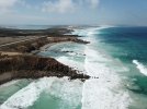
My current maps cosnsist of about 170 photos stitched and geo-referenced so that it is geometrically correct (I can measure crocs down to about 2-3cm accuracy).
I will be using it for mapping and am anxious to see how the results will look. Dronelink is awesome, you guys must give it a go.
Will post some of the maps I create.
In the meanwhile, if anyone here is interested in a map that I created with the mini using Dronelink and OpenDroneMap let me know (I cant post .tiff files in the thread) and I will share.
My current maps cosnsist of about 170 photos stitched and geo-referenced so that it is geometrically correct (I can measure crocs down to about 2-3cm accuracy).

")