DJI Mavic, Air and Mini Drones
Friendly, Helpful & Knowledgeable Community
Join Us Now

How rigid are the UK drone laws

123taff

Well-Known Member
Joined
Sep 26, 2020
Messages
105
Reactions
105
Age
69
Location
Wales UK
I live in South Wales UK and I have been flying for a number of years and my last drone was the Mavic Pro.

I bought the new Mini 3 Pro and the RC controller about 2 weeks ago and I have to say what a fantastic package it is.

I find it brilliant to fly with some superb features however; I wonder how seriously the CAA are expecting us to be able to fly legally.

The problems I have found with regards to that is that flying the mini within the confines of direct site. Obviously the Mavic, being larger was easier to see however, because the mini is smaller, I sometimes find it difficult to re-sight it, if I momentarily glance down at the screen to change a parameter. I then have to fly it POV until I can find it again. I don’t have problems with my eyesight before anyone asks.

The second issue is that according to the rules, we must maintain the 400 feet limit over any point on the ground. Where I live it is full of mountains and valleys so it is VERY difficult to know the height of the drone over any of the lower points as the altimeter on the controller only gives the height over the home point.

I do hope they don’t expect rigid adherence to the drone laws and would accept a certain amount of discretion in it’s enforcement.
 
@123taff the rules are the rules,and as long as you have done your due diligence,with regards to the airspace where you intend to fly ,made sure you have done everything in your power, to ensure your drone is airworthy,as far as humanly possible ,have checked the conditions ,on the day of your flight,in respect of the weather ,and have checked ,that there are no TFRs in place ,where you intend to fly ,and the drone is of a weight class ,that allows the flight to be done at that location,then you have demonstrated,that in the event of an unforeseen incident happening during your flight,that it was outside of your control,and not of your making.
if on the other hand you just dont care,about any of the above ,and just do what the heck you like ,then ,if this results in a serious incident,then you will be held accountable,for your actions
if as part of the investigation the CAA are involved,and it is found ,that your negligence ,was a contributing factor ,you could be facing a fine and confiscation of your equipment
but it would have to be something pretty serious ,for such action to be taken,the main roll of the CAA when it comes to drones ,is education ,not punishment
 
  • Like
Reactions: maelstrom
The second issue is that according to the rules, we must maintain the 400 feet limit over any point on the ground.
As far as I am aware that is incorrect and the rule the UK is. Your drone or model aircraft must never be more than 120m (400ft) from the closest point of the earth’s surface. which allows, in the UK, a drone to climb, in the most extreme example, a 400ft+ vertical cliff providing that the drone is within 400ft of the cliff face.
 
  • Like
Reactions: rjwmorrell
As far as I am aware that is incorrect and the rule the UK is. Your drone or model aircraft must never be more than 120m (400ft) from the closest point of the earth’s surface. which allows, in the UK, a drone to climb, in the most extreme example, a 400ft+ vertical cliff providing that the drone is within 400ft of the cliff face.
I think you will find it is vertical height they refer to "from the closest point of the earths surface," at least that is how it appears on their on line description.

Flying where there are hills, mountains or cliffs​

Your drone or model aircraft must never be more than 120m (400ft) from the closest point of the earth’s surface.

If you fly where the ground falls or rises, such as over hills, mountains or cliffs, you may need to adjust your flight path so that your drone or model aircraft is never more than 120m (400ft) from the closest point of the earth’s surface.

Obviously. if you are approaching a cliff face, then you would be permitted to be 400 feet above the top of it.
To be fair, that is my issue with it, My home point can be 1100 feet above the valley floor, meaning that if I fly over the valley bottom, technically I should be flying 700 feet below my home point if I am to maintain the maximum height of 400 feet.
 

Attachments

  • drone-code-120m-limit.png
    320.9 KB · Views: 7
the height readout on the screen has no bearing on the drones height during flight ,other than above the home point ,once you move out over a cliff or fly up a hill then you have to use best judgment to keep your drone at no more than 400ft above the surface wherever the drones position is at the time ,in the Beacons the lowest reading i have seen from my take off point was almost negative 250ft from the home point ,flying down into a valley ,the drone does not have an altimeter ,to show its true AGL ,
 
the height readout on the screen has no bearing on the drones height during flight ,other than above the home point ,once you move out over a cliff or fly up a hill then you have to use best judgment to keep your drone at no more than 400ft above the surface wherever the drones position is at the time ,in the Beacons the lowest reading i have seen from my take off point was almost negative 250ft from the home point ,flying down into a valley ,the drone does not have an altimeter ,to show its true AGL ,
You have a perfect understanding of what I am asking and your reference to the Brecon Beacons is also apt since I live within the boundaries of the BB National park . You wouldn't necessarily start from 400 feet above your home point, but if flying over the void of a valley, then it wouldn't take long to be at a height not compliant with the 400 feet limit. Take a particular location which you might know, Torpantau. For those who don't know, it is a mountain pass between two valleys containing spectacular reservoirs and a perfect home point for either direction, Pentwyn Reservoir to the South and Tal-Y-Bont to the north. In either case, if you started with a Home point height of say 200 feet. it would only take a flight of a few metres in either direction to be above the specific ground height. It is a very difficult situation to estimate the specific height and adjust accordingly besides which, shots of the reservoir below might be compromised and possibly unnecessarily so. There is a lot more to this drone flying than people first realise. Is there a leniency with the authorities for errors of judgement in such situations? I am not implying a disregard at any costs for the flying rules, and fully understand the need to be compliant at all times. But there must be situations caused by topography where strict adherence can be difficult to achieve.
 
There was and maybe still is another height diagram that shows an 400ft arrow perpendicular to the slope of the hill, I could not find it, it may have been on the drone safe site.

But if the rule was within 400ft of the ground beneath the drone, known as AGL, then why would the rule say "from the closest point of the earth's surface"? The two ideas, closest & above, are mutually compatible only over flat ground.
If AGL is the intended rule then "closest" is confusing and leaving the door open to argument.

If AGL is the rule a drone pilot can not fly their drone up and over the top of a 401ft vertical cliff face, they are legally limited to 400ft AGL and would be 1ft short of the cliff top.

Either way you are correct that when flying from that high home point and over the valley floor, with the closest ground being directly beneath the drone, then your drone should be 700ft or more below the take off point.
 
@Yorkshire_Pud ,hi my fellow flier,i think you are a bit confused about the 400ft AGL rule
say i take off from the valley floor, and then intend to fly up to the top of a hill, that is 420ft high
when i get to the top of the hill ,my drone would be ,for the sake of argument say at 450ft above the valley floor ,but only 30 ft above the ground beneath it at the top of the hill ,the above ground level, applies to the position of the drone above the surface below it , not where it took off from ,in simple terms imagine a weighted string hanging beneath the drone,that was 400ft long,as the drone follows the topography of the ground ,or say water even below it, and the end of the string is just in contact with the surface,then the drone would be in compliance with the 400ft rule ,what the drone needs is a laser rang finder pointing directly downwards,that then gives a display to the pilot, of the drones height above the ground ,where ever the drone happens to be flying at the time ,this is what the closest point to the earths surface rule means,not from the sides front or back of the drone ,but below it as it flies
so for the flight up the hill all i would need to do was go up to the point where the string just touched the ground and then fly up the hill keeping the string in contact with the ground below it all the way to the top ,and at no point during the flight was i more than 400 ft above the closest point of the surface, at the top i would actually be 800 ft above the take off point, but still only 400ft AGL
 
@old man mavic, no confusion here that I am aware of, unless it is in regards to the meaning of "closest".

My understanding of "closest" is that your string must be in contact with the ground somewhere and that that somewhere need not be below the drone but rather, if there was a suitable slope nearby, it could be off to one side of and below the drone. Or level with the drone if there was a vertical cliff face within 400 horizontal ft of the drone or even arguably above the drone if the cliff had an overhang. I.e. the closest ground would need to be within a sphere, centred on the drone, of radius 400ft.

If "closest" actually means AGL then a weighted string, up to 400ft long, would have to be in contact with the ground beneath the drone .....full stop. But then the question needs to be asked why use the word "closest" rather than "below"?

Couple that with the use of the phrase "earth's surface" rather than my lazy "ground" and I think the rule is quite precisely worded and means within at least a hemisphere of radius 400ft that is level with and below the drone, the above the drone hemisphere would be a bit extreme.

Sar104's post 27 in Flying uphill and keeping to the 120m above ground rule

1642021593633-png.141843

But realistically only a written answer from the CAA can say what their intention is.
 
Last edited:
@Yorkshire_Pud ,well for me its below the drone,which would be the case, as you either descended,or ascended a hill ,a cliff or shear drop is entirely different , so in this instance we will agree to differ ,on the point in question
 
  • Like
Reactions: Yorkshire_Pud
As far as I am aware that is incorrect and the rule the UK is. Your drone or model aircraft must never be more than 120m (400ft) from the closest point of the earth’s surface. which allows, in the UK, a drone to climb, in the most extreme example, a 400ft+ vertical cliff providing that the drone is within 400ft of the cliff face.
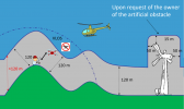
This graphic depicts what you are saying I think and how I understand the 400' rule here in the U.S. Description of 400 foot rule How high can I fly my drone.png
 
This graphic depicts what you are saying I think and how I understand the 400' rule here in the U.S.
Oh boy, in good natured humour, lol, this is quite funny.
Gingorio's graphic is my understanding of UK law, EXCLUDING the structure/building/turbine thing.
However I believe it is NOT the correct depiction of USA regulations for recreational pilots. For USA recreational pilots I believe the rule is strictly 400ft AGL i.e. the 400ft weighted string must be able to, in theory, touch the ground directly beneath the drone.
I also believe the exemption for flights above structures etc. applies to only USA part 107 pilots and DOES NOT apply to recreational pilots.
Looking at FAA regs for recreational drone operators here in the States, looks like you're right "Fly at or below 400 feet". The weighted string below the drone is a good visual. Interesting differences between the FAA and CAA 400'/120m rule.
 
Actually the graphic you cited is EASA (EU) regs, I didn't realise they had rules about extra height over structures.
What a minefield of differing regs across the world!!!!!!:D
 
I live in South Wales UK and I have been flying for a number of years and my last drone was the Mavic Pro.

I bought the new Mini 3 Pro and the RC controller about 2 weeks ago and I have to say what a fantastic package it is.

I find it brilliant to fly with some superb features however; I wonder how seriously the CAA are expecting us to be able to fly legally.

The problems I have found with regards to that is that flying the mini within the confines of direct site. Obviously the Mavic, being larger was easier to see however, because the mini is smaller, I sometimes find it difficult to re-sight it, if I momentarily glance down at the screen to change a parameter. I then have to fly it POV until I can find it again. I don’t have problems with my eyesight before anyone asks.

The second issue is that according to the rules, we must maintain the 400 feet limit over any point on the ground. Where I live it is full of mountains and valleys so it is VERY difficult to know the height of the drone over any of the lower points as the altimeter on the controller only gives the height over the home point.

I do hope they don’t expect rigid adherence to the drone laws and would accept a certain amount of discretion in it’s enforcement.
I also live in South Wales, Flying my drone within the Drone Code to me is not difficult. If using the example of the reservoirs as the example, if I cannot include them both in my image because of height restrictions I would fly further away to bring them both into view as long as vlos was ensured. If not photograph them individually. The Drone Code is the Drone Code, if you take a chance and fly outside of this code and don’t have any sort of incident whilst doing so, it’s your choice, but if you disregard this code and something happens then you carry the blame and could be punished accordingly . Omm description of a piece of string is extremely valid and Drone flyers should remember it. Many years ago I was an Ambulance Driver and have seen to many drivers flout the driving rules and caused mayhem , injury and death for doing so. I know we are talking about a drone but I do not want to be responsible for being that person that causes injury or death to any person because of my decision to not fly within the Drone Code. Get serious, I think even my Mavic Mini 3 would seriously injure someone if it fell from 400 ft and hit them. My opinion only, cheers Len
 
  • Like
Reactions: old man mavic
Whilst I didn't wish to cause any friction, and an otherwise interesting debate has ensued, I still feel I haven't had my concern answered. Funnily enough I retired 2 years ago after 35 years as an Ambulance Officer with the Welsh Ambulance service, and 7 years prior to that I was a police Constable with Gwent Police, so I am NOT advocating flying outside of the rules in ANY form.

My original concern was based on the fact that on flat ground or within the vicinity of the home point, it is easy to maintain the required flying below 400 feet rule because of the altitude displayed on the controller, but in the circumstances where you fly on a downslope, and in my case a dramatic change of ground altitude in a short distance, it is difficult to be exact. So my concern was is there any perceived leniency if your judgment is for example 20 feet out?

The answer of course might be some sort of built in radar based technology, or positional technology based on the GPS position above the ground that would indicate EXACT ground height below the drone on the display, but that of course would add extra cost, but in view of the strict rules employed in most countries regarding this aspect, you would think that drone manufacturers would consider such measures and build them in.
 
Last edited:
So my concern was is there any perceived leniency if your judgment is for example 20 feet out?
If nothing happens then in those circumstances I, for one, would think there would bit of leeway but that could always be countered by them saying "aim to fly below 400ft AGL". Of course you would have to be caught doing it.

BUT if something happened with consequences and (leaving aside "closest") you were at 420ft AGL then you could be in difficulties.

With regards to a data base of ground altitude vs location, is what is commercially available accurate enough to rely on it to within ± 20ft?
 
Last edited:
If nothing happens then in those circumstances I, for one, would think there would bit of leeway,and of course you would have to be caught doing it but that could always be countered by saying "aim to fly below 400ft AGL".

BUT if something happened with consequences and (leaving aside "closest") you were at 420ft AGL then you could be in difficulties.

With regards to a data base of ground altitude vs location, is what is commercially available accurate enough to rely on it to within ± 20ft?
Yes thanks mate, my thoughts are leaning towards that angle too, in as much that as long as you do your best to adhere to the rules, then there has to be a certain amount of give and take.

Your point too that you would need to be "caught" in contravention of those regs and even if a mishap occurred, speaking as an ex Policeman, it would be difficult to prove that you were 20 feet out, (or at least deliberately and knowingly flew 20 feet out)much more so that a flagrant breech of flying law.

With regards to your last question, most commercially based GPS mapping contain very accurate altitude profiles. I use Memory Map on my phones which give and instant readout of up to 10 figured positional data AND precise altitude information. I have that software on my home computer too, and placing the cursor onto any part of the map gives similar instant readings.

As drones use the same satellite signals giving that very data, it would be a simple exercise to incorporate that information into the display and use a comparison algorithm with the recorded home point to give an instant AGL reading!
.
 
Last edited:
  • Like
Reactions: Yorkshire_Pud
@123taff as has already been mentioned,there is no real way for you to know the precise ,AGL figure ,from the readout on the App screen, once you leave the home point ,and travel over terrain that is reasonably flat ,in relation to your home point ,then the readout will be fairly accurate around 10ft to 15ft plus or minus ,of your actual height, ,but once the ground drops away ,or rises up then the screen readout is of no real use ,in indicating AGL
 
I had the opposite thing happen to me yesterday. I was flying up slope to video a limestone column known as the Lonely Shepherd. I took off and flew up the slope to take up a position above the formation to begin some planned shots.
I got the screen warning that I had exceeded the maximum height limit, but of course that was from my take off home point. It wasn't a problem though because I could still see the drone and I knew it wasn't too high above AGL height.
This has prompted another question though. If you use the height limiting feature in the app and set it to the maximum 400 feet, what happen when you fly towards a slope that is higher than that 400 feet maximum?
I assume the drone's forward facing obstacle avoidance would stop the drone, but would you then have to reset the maximum ceiling to be able to proceed further up the slope?

I still think that there would be a possibility to have an AGL reading on the screen extrapolated from the GPS data and perhaps that is something that could be considered by DJI in a future firmware update?

As for my original question as to how rigid the laws are enforced, I have concluded that as long as we attempt to follow the laws as best we can, they are as written sufficiently vague to introduce an element of doubt.

Another example of that is the law that an under 250g drone is permitted to fly over "uninvolved people" but not a crowd. So, what is a crowd? The legislation does attempt to give an explanation as "people who would find it difficult to move away" but again, it seems sufficiently vague to be open to legal interpretation in the event of any proceedings.
 
Last edited:
  • Like
Reactions: old man mavic
Lycus Tech Mavic Air 3 Case

DJI Drone Deals

New Threads

Forum statistics

Threads
130,593
Messages
1,554,197
Members
159,598
Latest member
fast54