DJI Mavic, Air and Mini Drones
Friendly, Helpful & Knowledgeable Community
Join Us Now

Flying uphill and keeping to the 120m above ground rule

It doesnt matter where you are. Your drone must be 120m (or 400 feet) to nearest surface.
I'm asking in context to the regs that say you can fly 400' above a structure, but must be within 400' of it horizontally.
 
That is the current UK interpretation:

Flying where there are hills, mountains or cliffs​

Your drone or model aircraft must never be more than 120m (400ft) from the closest point of the earth’s surface.


Yes, I recall I saw a similar thread a while ago here, related to the UK as this one is.
It had the diagram I posted, with the hillside and 400’ distance from the slopes of a hill giving a possible greater distance AGL in that circumstance.

I tried finding the that on the UK CAA site, but couldn’t, the diagram above was on some sort of aeronautical modellers site.
I think that rule is obsolete now perhaps, because the CAA link you posted has the rule is we know it here in Australia , and I believe for FAA interpretation in the US . . . it is the distance AGL directly under the drone.

Man made structures, as some are posting about here too, are possibly different in those respective countries also, and may vary for recreational and commercial UAV pilots.
 
That is the current UK interpretation:

Flying where there are hills, mountains or cliffs​

Your drone or model aircraft must never be more than 120m (400ft) from the closest point of the earth’s surface.


Hmm. That page could maybe do with some clarification as it seems to contradict itself. Firstly, the CAA states this:

3. Fly below 120m (400ft)
Flying below the legal height limit of 120m (400ft) will reduce the risk of coming across other aircraft, which normally fly higher than this.

That's pretty imperative, given it's a major heading and is accompanied by the image that only shows 120m measured vertically and directly below the aircraft. But then, immediately after that, is the sub-section you quoted above; "from the closest point", which it then re-iterates with:

If you fly where the ground falls or rises, such as over hills, mountains or cliffs, you may need to adjust your flight path so that your drone or model aircraft is never more than 120m (400ft) from the closest point of the earth’s surface.

However, going back to the original drawing, the two marked points are over level terrain to the side of the hill and directly over the summit, e.g. the closest point to the terrain is a straight vertical of 120m - there isn't a 120m indication provided for the slope of the hill! Taking all that together, I think it's intended as a general case - 120m AGL - with a specific exception for hills, mountains, and cliffs where the 120m can be measured as the distance from the closest point on the ground in any direction.
 
However, going back to the original drawing

The one I posted or the ine in the CAA website link ?
Or is there another posted previously too ?

There seems to be a contrast in written terms and the website diagram that seems to be contradictory.

The text explanation suits the diagram I posted above ?
(Sorry, hard to scan thread easily on phone browser.)
The one on the CAA page:

drone-code-120m-limit.png
 
  • Like
Reactions: zeusfl
The one on the CAA page:

drone-code-120m-limit.png

Yeah, that's our rule here, and I think in the US.

The diagram I posted (post 15) is probably obsolete, still on this modellers site I found it some month ago.

It makes more sense, thinking that any plane flying say 500m above flat terrain, is probably going to fly over low hills the same altitude AMSL, rather than up and down all the time trying to follow terrain.
A drone flying as per the diagram in either case could get closer than the desired 100m buffer between drone max alt, and aircraft (usual) min alt.

So, in the case of the CAA diagram, this is somewhat safer than the one I had found back a while.
That diagram I posted probably did exist on the CAA site at some point, as per the modellers notations at the time.

My gut feeling is most pilots or light aircraft would just play it safe in such terrain and fly a little higher to keep their height at a safer alt above their planned route.
 
Yes, I recall I saw a similar thread a while ago here, related to the UK as this one is.
It had the diagram I posted, with the hillside and 400’ distance from the slopes of a hill giving a possible greater distance AGL in that circumstance.

I tried finding the that on the UK CAA site, but couldn’t, the diagram above was on some sort of aeronautical modellers site.
I think that rule is obsolete now perhaps, because the CAA link you posted has the rule is we know it here in Australia , and I believe for FAA interpretation in the US . . . it is the distance AGL directly under the drone.

Man made structures, as some are posting about here too, are possibly different in those respective countries also, and may vary for recreational and commercial UAV pilots.
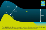
No - in the link above it clearly says 400 ft "from the closest point". Was this the CAA schematic that you were remembering:

1642021593633.png
 
Hmm. That page could maybe do with some clarification as it seems to contradict itself. Firstly, the CAA states this:


That's pretty imperative, given it's a major heading and is accompanied by the image that only shows 120m measured vertically and directly below the aircraft. But then, immediately after that, is the sub-section you quoted above; "from the closest point", which it then re-iterates with:


However, going back to the original drawing, the two marked points are over level terrain to the side of the hill and directly over the summit, e.g. the closest point to the terrain is a straight vertical of 120m - there isn't a 120m indication provided for the slope of the hill! Taking all that together, I think it's intended as a general case - 120m AGL - with a specific exception for hills, mountains, and cliffs where the 120m can be measured as the distance from the closest point on the ground in any direction.
You are trying to interpret the drawing far too literally. The wording is unambiguous.
 
  • Like
Reactions: Meta4
No - in the link above it clearly says 400 ft "from the closest point". Was this the CAA schematic that you were remembering:

View attachment 141843

I was checking in from the phone, very hard to operate multiple windows etc, so if the above is from a current 'drone safe' official site, they yeah that rule for the UK is still relevant.

I feel it's a reasonable way to do the drone max alt, especially around steep hills / cliffs etc . . . but of course the way it's done here (and the US ?) for terrain it's always AGL where the drone is, and does give that little more safety margin for manned aircraft flying low over terrain.
 
No one has addressed as to whether or not you need to be in 400' horizontal proximity of the hill.
 
No one has addressed as to whether or not you need to be in 400' horizontal proximity of the hill.
The discussion is about rules in Britain.
It's does not apply in other countries.

The rule there is 400 ft from the closest point of the earth’s surface.
It's quite clear what that means.
 
Yeah the closest point of the hill in re: AGL Just curious about the operator parameters.
 
You are trying to interpret the drawing far too literally. The wording is unambiguous.

Not really - I was trying to explain where the misinterpretation is likely coming from and think the wording is pretty clear too. "120m from the nearest surface" could absolutely mean a near-vertical cliff face, and thus putting the drone well over 120m AGL measured vertically. OK, it's stated in the specific context of hilly or mountainous terrain, but it would have to be hilly or mountainous terrain for that to apply, wouldn't it; if you're flying over flat ground then that 120m is always going to be straight down.

Where the confusion is coming from seems to be that the current CAA drawing only shows that 120m measured vertically, which is leading people to assume that must be how it needs to be measured, regardless of what the text actually says. While the drawing isn't wrong, because where they show the 120m lines the nearest surface is directly below the drone, if they replaced the dotted line to the drone with another 120m indicator that would clear up any misinterpretation of the text.

A good picture might be worth a thousand words, but a bad one merely produces a thousand posts of discussion it seems. ;)
 
Not really - I was trying to explain where the misinterpretation is likely coming from and think the wording is pretty clear too. "120m from the nearest surface" could absolutely mean a near-vertical cliff face, and thus putting the drone well over 120m AGL measured vertically.
Yes. That's what it means.
OK, it's stated in the specific context of hilly or mountainous terrain, but it would have to be hilly or mountainous terrain for that to apply, wouldn't it; if you're flying over flat ground then that 120m is always going to be straight down.
Yes, obviously.
Where the confusion is coming from seems to be that the current CAA drawing only shows that 120m measured vertically, which is leading people to assume that must be how it needs to be measured, regardless of what the text actually says.
"People" meaning you?
While the drawing isn't wrong, because where they show the 120m lines the nearest surface is directly below the drone, if they replaced the dotted line to the drone with another 120m indicator that would clear up any misinterpretation of the text.

A good picture might be worth a thousand words, but a bad one merely produces a thousand posts of discussion it seems. ;)
The other CAA diagram that I included in post #27 is clearer, but I have no idea why you are so determined to sow confusion on such a simple subject.
 
Be careful for flying above launch point + 120m! If you lose connection (or remote battery dies, or phone freezes), during RTH your drone will maintain altitude and you'll break the altitude rule.

Posting a video where the pilot is 1000m+ above the launch point. It's all legal but if he would have lost connection, the drone would have returned at 1000m altitude.

 
Way BVLOS too.
 
No one has addressed as to whether or not you need to be in 400' horizontal proximity of the hill.
If in the UK, imagine a 400ft long piece of string tied to the drone. According to the CAA diagram of post 27 etc. the string must be in contact with the ground.
 
If in the UK, imagine a 400ft long piece of string tied to the drone. According to the CAA diagram of post 27 etc. the string must be in contact with the ground.
But not necessarily vertical.
 
The ' 400' from the Earth in any orientation' interpretation of the CAA rules is certainly correct. What you cannot do is descend once over the hill, taking you out of VLOS....
 
Lycus Tech Mavic Air 3 Case

DJI Drone Deals

New Threads

Forum statistics

Threads
130,600
Messages
1,554,275
Members
159,607
Latest member
Schmidteh121